Ohio, Indiana, Michigan, Pennsylvania, and West Virginia Face Tuesday–Friday Arctic Blast With Wind Chills Plunging to -30°F and Below
OHIO — A prolonged and potentially historic stretch of extreme cold is setting up across Ohio and much of the Midwest and Appalachians, with forecast wind chills rivaling some of the coldest conditions ever recorded in the region. Forecast data shows dangerously low wind chill values persisting from Tuesday through Friday, raising serious concerns for safety, infrastructure, and daily travel.
Meteorologists warn this is not a brief cold snap. Instead, it is a sustained Arctic outbreak that will keep much of Ohio, Indiana, Michigan, Pennsylvania, and West Virginia locked in hazardous cold for several consecutive mornings.
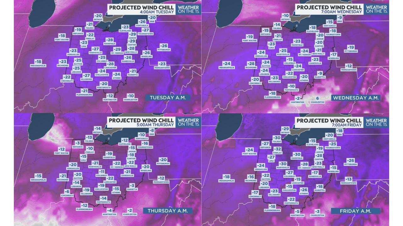
Wind Chills in Ohio Expected to Plunge Below -30 Degrees
Forecast wind chill maps show Ohio at the core of the cold, with many communities experiencing wind chills between -20°F and -30°F, and some areas dipping even lower during the overnight and early morning hours.
Cities including Columbus, Dayton, Cincinnati, Cleveland, Akron, Mansfield, Lima, Zanesville, Chillicothe, Athens, Portsmouth, and Toledo are all expected to see multiple mornings where exposed skin can develop frostbite in minutes.
The most extreme conditions are projected early Tuesday, Wednesday, Thursday, and Friday mornings, with little daytime recovery due to persistent cold air and limited solar warming.
Surrounding States Face Similar Life-Threatening Conditions
The cold air mass does not stop at Ohio’s borders. Data shows widespread dangerous wind chills expanding into neighboring states:
- Indiana: Indianapolis, Fort Wayne, Richmond, and surrounding areas seeing wind chills from -15°F to -25°F
- Michigan: Detroit and southern Michigan communities dropping to -20°F to near -30°F
- Pennsylvania: Pittsburgh and western Pennsylvania facing wind chills in the -20°F range
- West Virginia: Morgantown and northern areas dipping into the single digits below zero, with colder values in higher terrain
This multi-day event increases risk because there is little opportunity for people, vehicles, or infrastructure to recover between cold surges.
Why This Cold Is Especially Dangerous
Forecasters describe this Arctic intrusion as hazardous to dangerous, not just cold. Wind amplifies the threat by stripping heat from exposed skin at alarming rates.
Key dangers include:
- Frostbite in 10 minutes or less
- Increased risk of hypothermia
- Frozen pipes and infrastructure failures
- Vehicle issues including dead batteries and gelled fuel
- Dangerous conditions for anyone stranded outdoors
Officials stress that even brief exposure without proper protection can become life-threatening.
Travel and Daily Life May Be Impacted All Week
While snowfall may be limited in some areas, the cold alone poses major risks. Vehicles may struggle to start, and any residual moisture on roads can refreeze quickly overnight.
Schools, outdoor work schedules, and travel plans across Ohio and surrounding states may face disruptions as the cold persists deep into the week.
Residents are urged to:
- Limit time outdoors
- Wear layered, insulated clothing
- Protect pets and livestock
- Check on vulnerable neighbors
- Prepare homes for prolonged cold
No Immediate Warm-Up in Sight
Forecast trends suggest this is not a one- or two-day event. Instead, the pattern supports continued Arctic air through the workweek, with the coldest mornings arriving midweek into Friday.
Meteorologists note that while exact values may fluctuate, the severity of the pattern is not in doubt, and this stretch may rank among the coldest late-January periods many residents have experienced in years.
Have you experienced extreme cold like this before in your area? Share your thoughts and local conditions with us at CabarrusWeekly.com.