The Northeast, Plains, and South Face Opposite Extremes as Mid-May Outlook Signals Heat, Cold, and Heavy Rain From May 13 to 19
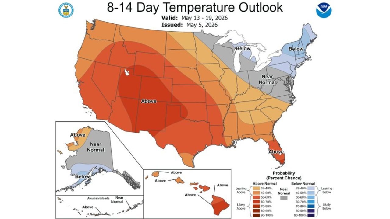
UNITED STATES — The Climate Prediction Center’s 8 to 14 day outlook issued May 5, 2026 and valid May 13 through 19 shows a sharply divided country, with dangerous above-normal heat dominating the West, Plains, and South, below-normal temperatures gripping the Northeast, and wetter than normal conditions favored across the South and much of the East.
A Nation Split in Two by Temperature
The temperature outlook for May 13 through 19 tells two very different stories depending on where you live.
Across the West, Southwest, Central and Southern Plains, and South, above-normal temperatures are heavily favored with probabilities reaching 60 to 90 percent above normal across the core of the heat signal. Texas, Oklahoma, Kansas, Colorado, California, Nevada, and Arizona sit inside the most intense warmth zone.
Meanwhile, the Northeast and Great Lakes are facing the opposite, with below-normal temperatures favored across New England, New York, Pennsylvania, and the upper Midwest. Near-normal readings are expected across the Mid-Atlantic and central portions of the country as a buffer zone between the two extremes.
Heat Signal by Region May 13 to 19
| Region | Temperature Signal | Probability |
|---|---|---|
| Texas, Oklahoma, Kansas | Well Above Normal | 70 to 90 percent |
| California, Nevada, Arizona | Above Normal | 60 to 80 percent |
| Florida | Above Normal | 50 to 60 percent |
| Mid-Atlantic | Near Normal | Equal Chances |
| New England, New York | Below Normal | 40 to 60 percent |
| Pacific Northwest Oregon | Below Normal | 40 to 50 percent |
Northeast Cooler and Wetter Heading Into Mid-May
The National Weather Service Climate Prediction Center confirms that cooler than normal temperatures are favored over the Northeast as the region approaches mid-May. Alongside the cool signal, wetter than normal conditions are slightly favored across the same period for the Northeast, meaning residents from New England through the Mid-Atlantic should expect periods of rain along with below-normal temperatures.
Heavy Rainfall Favored Across the South and East
The precipitation outlook for May 13 through 19 shows above-normal precipitation favored across a broad area stretching from the Gulf Coast northward through the Ohio Valley and into the Northeast.
The most significant wet signal is centered across southern Texas and the Texas Gulf Coast, where precipitation probabilities of 60 to 70 percent above normal are indicated. Above-normal rainfall extends across Louisiana, Mississippi, Alabama, Tennessee, Kentucky, Indiana, Ohio, and into the Mid-Atlantic and Northeast.
The only area facing below-normal precipitation during this period is the Pacific Northwest, specifically Oregon and northern Washington, which continues a drying trend already in place across that region.
Precipitation Signal by Region May 13 to 19
| Region | Precipitation Signal | Probability |
|---|---|---|
| Southern Texas, Gulf Coast | Above Normal | 60 to 70 percent |
| Louisiana, Mississippi, Alabama | Above Normal | 50 to 60 percent |
| Ohio Valley, Mid-Atlantic, Northeast | Above Normal | 33 to 50 percent |
| Oregon, Pacific Northwest | Below Normal | 40 to 50 percent |
| Central Plains, Rockies | Near Normal | Equal Chances |
What This Means Going Into the Third Week of May
The pattern setting up for May 13 through 19 reinforces an increasingly split country. The West and South bake under an expanding heat signal while the Northeast braces for cool and wet conditions. Southern Texas faces the greatest combined risk with both extreme heat earlier in the period and the heaviest rainfall signal for the region.
Stay with CabarrusWeekly.com for continuing updates on the mid-May outlook as the pattern evolves.