Eastern United States Faces Multi-Day Trough Pattern With Above Normal Precipitation for the South and East Coast While Enhanced Risk Severe Weather Targets South Central States Sunday
EASTERN UNITED STATES — A persistent trough locked over the Eastern United States will keep rain and storm chances pushed toward the South and up the East Coast over the next several days, with the most significant severe weather threat arriving Sunday as energy moves across the South Central United States. The 7-day and 5-day precipitation anomaly data confirm the highest above-normal rainfall signal concentrated across the South and East.
The Pattern in Place Right Now
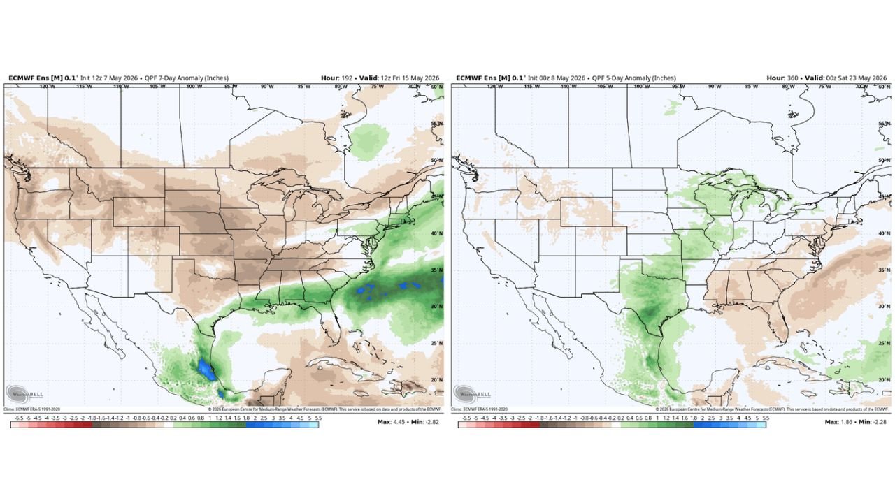
The Eastern United States is locked in a consistent trough pattern that will dominate the weather setup for the next several days. This trough is keeping the best storm and rain chances focused across two areas: the South and up the East Coast. The West and much of the central United States remain in a below-normal precipitation signal shown in brown on the 7-day anomaly map valid through Friday May 15, 2026.
A coastal low could develop next work week but may stay off the East Coast depending on the strength and placement of the trough as the pattern evolves.
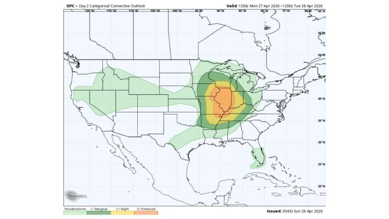
Sunday Is the Day to Watch — Enhanced Risk Possible
Any severe weather over the next couple of days will remain further south within a northwest flow regime. However, Sunday stands out as a higher-end severe weather day as energy moves across the South Central United States. The severe risk is currently at a Slight Risk level but forecasters are watching for the potential to be upgraded to an Enhanced Risk as the setup becomes clearer.
Residents across the South Central United States should closely monitor forecasts heading into the weekend.
What the Precipitation Anomaly Maps Show
The 7-day QPF anomaly valid through 12Z Friday May 15 shows:
| Region | Signal |
|---|---|
| South and Southeast | Above normal precipitation |
| East Coast corridor | Above normal precipitation |
| West and Central United States | Below normal — dry signal in brown |
The 5-day QPF anomaly valid through 00Z Saturday May 23 shows a shift in the pattern with the above-normal signal moving into the Central United States including Texas, Oklahoma, and the Plains, while the Southeast and East Coast dry out somewhat as the ridge moves in from the West.
Mid-Month Pattern Change Coming
As the region moves deeper into next week and into the mid-May timeframe, upper-level features are expected to switch as the trough in the East breaks down and a ridge moves in from the West. When this happens, severe weather risk will likely begin in the High Plains first as southwesterly flow develops, with the potential to push further east in time.
The ECMWF ensemble data shows a green active signal returning across the middle of the country from day 10 to 15, indicating the potential for an active severe weather pattern beginning in the mid-May period.
The Bottom Line for the Next Several Days
For now the pattern remains relatively calm for much of the country outside of the South and East Coast. The immediate focus should be on Sunday’s severe weather potential across the South Central United States, with a longer-term eye toward a more active pattern developing across the Plains and Central United States from mid-May onward.
Stay with CabarrusWeekly.com for continuing updates on the evolving pattern through mid-May and the developing Sunday severe weather threat.