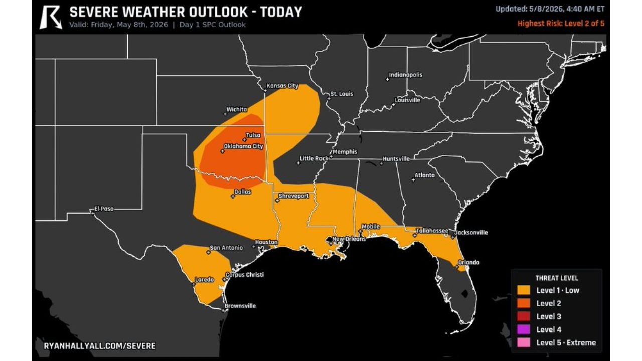
Kansas, Oklahoma, and North Texas Face Slight Risk Severe Weather Friday With Large Hail up to 2 Inches and Damaging Wind Line Moving South Through the Night on May 8
KANSAS — A Level 2 of 5 Slight Risk of severe weather is in place across a broad corridor stretching from Kansas down through Oklahoma and into north Texas on Friday, May 8, 2026, with large hail up to 2 inches possible this afternoon followed by a damaging wind line moving south through the night hours. The outlook was updated at 4:40 AM ET on May 8, 2026.
The Risk Zones for Friday May 8
The outlook shows two distinct threat levels across a wide area of the South Central United States:
Level 3 core zone — the highest risk area on the map — is centered over Tulsa and Oklahoma City, Oklahoma, extending toward Wichita, Kansas to the north and the Dallas, Texas corridor to the south.
A broad Level 2 zone surrounds the core and extends across a much wider area including:
- Kansas City, Missouri
- Little Rock, Arkansas
- Shreveport, Louisiana
- Houston and San Antonio, Texas
- New Orleans, Louisiana
- Mobile, Alabama
- Tallahassee and Jacksonville, Florida
- South Texas including Corpus Christi, Laredo, and Brownsville
Hazards and Timing Friday
| Threat | Timing |
|---|---|
| Large Hail up to 2 inches | This afternoon |
| Damaging Wind Line | Moving south through the night |
The severe weather setup unfolds in two phases. The afternoon hours bring the large hail threat as storms fire across the Oklahoma and Kansas corridor. As the day progresses into the overnight hours, a organized line of storms capable of damaging winds pushes southward through the risk zone.
Cities Most at Risk Friday
Residents across the following communities should remain on high alert through Friday afternoon and into the overnight hours:
- Tulsa and Oklahoma City, Oklahoma — inside the Level 3 core
- Wichita, Kansas — northern edge of the core zone
- Dallas, Texas — southern corridor of the elevated risk
- Shreveport, Louisiana and Little Rock, Arkansas — broad Level 2 zone
- Houston and New Orleans — outer Level 2 coverage
What Residents Must Do Friday
With large hail up to 2 inches possible this afternoon and a damaging wind line moving through overnight, residents across the entire risk corridor should secure outdoor property, have a plan to protect vehicles from hail, and stay weather aware well into the overnight hours. Do not assume the threat is over after sunset.
Stay with CabarrusWeekly.com for continuing updates on Friday’s severe weather threat across Kansas, Oklahoma, Texas, and the broader Gulf Coast region.