Mississippi, Alabama, Georgia, and the Carolinas Run 5 to 7 Degrees Below Normal Through May 12 as Lingering Front Keeps the South Cool While Central Florida Stays Warmer Than Average
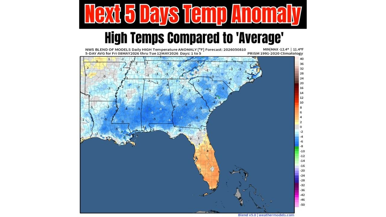
MISSISSIPPI — A lingering frontal boundary is keeping high temperatures well below normal across a broad swath of the South and East through the coming weekend and into next week, with the 5-day rolling average of high temperature anomalies showing readings of 5 to 7 degrees below normal across the core cool zone. The forecast covers Friday May 8 through Tuesday May 12, 2026.
The 5-Day Temperature Anomaly Breakdown
The NWS Blend of Models 5-day average high temperature anomaly shows the following departures from the 1991 to 2020 climatology across the region:
| State or Region | Temperature Anomaly |
|---|---|
| Mississippi and Alabama core | 5 to 7 degrees below normal |
| Georgia | 3 to 5 degrees below normal |
| North and South Carolina | 3 to 5 degrees below normal |
| Louisiana and Arkansas | 4 to 5 degrees below normal |
| Tennessee | 3 to 5 degrees below normal |
| Northern Florida | 1 to 3 degrees below normal |
| Central and South Florida | 1 to 5 degrees above normal |
| Virginia and Mid-Atlantic | 1 to 3 degrees below normal |
The coldest anomalies on the map reach as low as -7 degrees across portions of central Mississippi and Alabama, representing the deepest below-normal departures during this 5-day period.
What Is Keeping the South Cool
A lingering frontal boundary is the primary driver keeping temperatures suppressed across the South and East through the weekend and into early next week. This front is holding cooler air in place across the region while preventing any significant warmup from taking hold before mid-May.
Central and South Florida the Exception
While most of the South and East runs below normal, central and south Florida stands out as the warm spot on the map with anomalies of 1 to 5 degrees above normal through the same period. The frontal boundary is keeping its influence north of the Florida Peninsula, allowing warmer than normal conditions to persist across the state’s middle and southern sections.
How Far Below Normal Is It Really
Forecasters note that while the anomalies look significant on the map, for most locations the departures represent temperatures running only about 5 degrees below average for this time of year — notable but not extreme. The combination of the lingering front and cloud cover is the main contributor to the below-normal readings rather than any dramatic cold air outbreak.
Stay with CabarrusWeekly.com for continuing updates on the temperature pattern across the South and East through mid-May.