North Carolina Sees Surprise Elevated Thunderstorms With Lightning Saturday Morning as Warm Front Triggers Above-Surface Instability Across Charlotte and Winston-Salem Region
NORTH CAROLINA — An unexpected round of elevated thunderstorms with lightning moved through the Charlotte and Winston-Salem corridor on Saturday morning, May 9, 2026, surprising forecasters despite surface temperatures holding in the low to mid 50s. The storms were driven not by surface instability but by elevated CAPE above the surface layer, triggered by an advancing warm front.
Why Lightning Happened Despite Cool Surface Temperatures
The key to understanding Saturday morning’s surprise lightning events lies in the atmospheric sounding valid Saturday May 9, 2026 at 12Z. While surface conditions were cool with temperatures near 55 to 56 degrees Fahrenheit, the sounding revealed elevated instability above the surface layer that was sufficient to support thunderstorm development.
These storms are classified as elevated thunderstorms, meaning they feed off instability that exists above the cool surface air rather than at the ground level. This type of thunderstorm commonly occurs when a warm front moves into a region, lifting warmer and more unstable air over the cooler surface layer below.
What the Sounding Data Shows
The HRRR sounding valid Saturday May 9, 2026 at 12Z for the Charlotte area revealed the following atmospheric parameters:
| Parameter | Value |
|---|---|
| Surface Temperature | 55°F |
| Lifted Condensation Level | 775 m |
| Level of Free Convection | 2060 m |
| Most Unstable CAPE | 204 J/kg |
| Precipitable Water | 1.15 inches |
| Convective Temperature | 75°F |
| Mean Relative Humidity 850-500mb | 93% |
| Tornado Probability | 0 percent |
| Significant Hail Probability | 0 percent |
The Most Unstable CAPE of 204 J/kg confirmed the presence of elevated instability above the surface sufficient to support the lightning-producing storms observed across the region. Tornado and significant hail probabilities were both 0 percent, confirming this was a non-severe but surprising event.
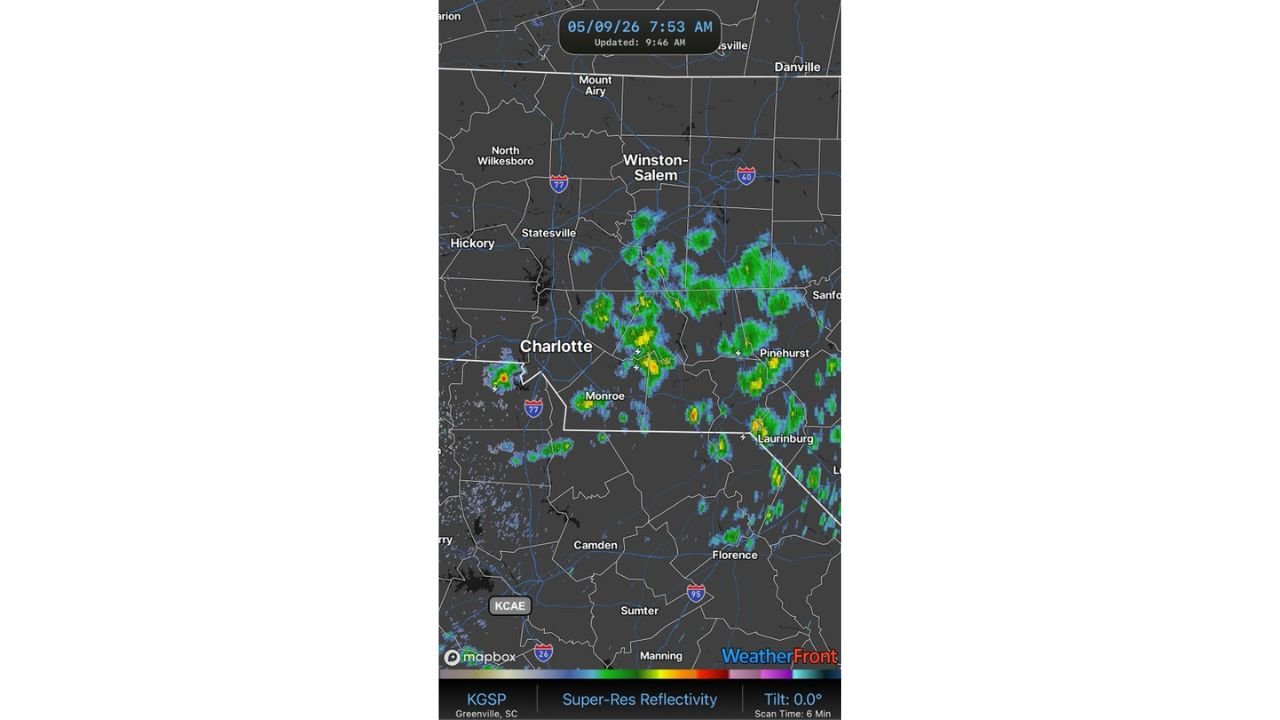
Where the Storms Were Tracked Saturday Morning
Radar valid at 7:53 AM on May 9, 2026 showed a cluster of showers and elevated thunderstorms centered across a corridor stretching from Charlotte and Monroe northeastward through Winston-Salem, Pinehurst, and Laurinburg. Lightning strikes were confirmed across the Charlotte metro and surrounding communities during the morning hours.
What Elevated Thunderstorms Mean
Elevated thunderstorms are a relatively uncommon but well-understood phenomenon. They occur when:
- A warm front moves into the region
- Cool surface air stays in place below
- Warmer unstable air rides up and over the cool surface layer
- Thunderstorm development occurs above the surface inversion
Because the instability is elevated rather than surface-based, these storms can produce lightning and heavy rain even when surface temperatures feel far too cool for thunderstorm activity.
Stay with CabarrusWeekly.com for continuing updates on weather conditions across North Carolina and the Charlotte region through the weekend.