Oklahoma and Northwest Texas Face Isolated to Scattered Severe Storms Saturday Afternoon and Evening With Large to Very Large Hail, Tornadoes, and Damaging Winds Possible on May 9
OKLAHOMA AND NORTHWEST TEXAS — Isolated to widely scattered severe storms are expected across parts of Oklahoma and northwest Texas on Saturday, May 9, 2026, mainly during the late afternoon and evening hours. The primary hazard is large to very large hail, with a couple of tornadoes and damaging winds also possible. The SPC Day 1 outlook was issued Saturday May 9, 2026 at 1203 UTC and is valid through Sunday May 10 at 1200 UTC.
The Risk Zones for Saturday May 9
The SPC categorical outlook shows a Slight Risk centered over a defined zone covering portions of Oklahoma and northwest Texas, surrounded by a broader Marginal Risk extending across a wider area of the Southern Plains.
The 3km Max Updraft Helicity forecast valid Saturday May 9 at 9:00 PM CDT shows the most intense storm rotation values concentrated near Memphis, Texas with values reaching the highest levels on the scale, and secondary areas of elevated helicity near Altus, Oklahoma and the surrounding corridor.
Hazards Expected Saturday Afternoon and Evening
| Threat | Status |
|---|---|
| Large to Very Large Hail | Primary Threat — Hatched significant hail zone indicated |
| Damaging Winds | Possible — Hatched significant wind zone indicated |
| Tornadoes | A couple possible — tornado probability zone outlined |
What Is Limiting the Tornado Threat
Despite the severe weather setup, forecasters note that high dew point depressions, low-level dry air, and crosswise vorticity will considerably limit the tornado threat with this event. However, mesoscale interactions could still favor tornadogenesis with the more robust storms that develop, meaning a tornado cannot be ruled out even with the limiting factors in place.
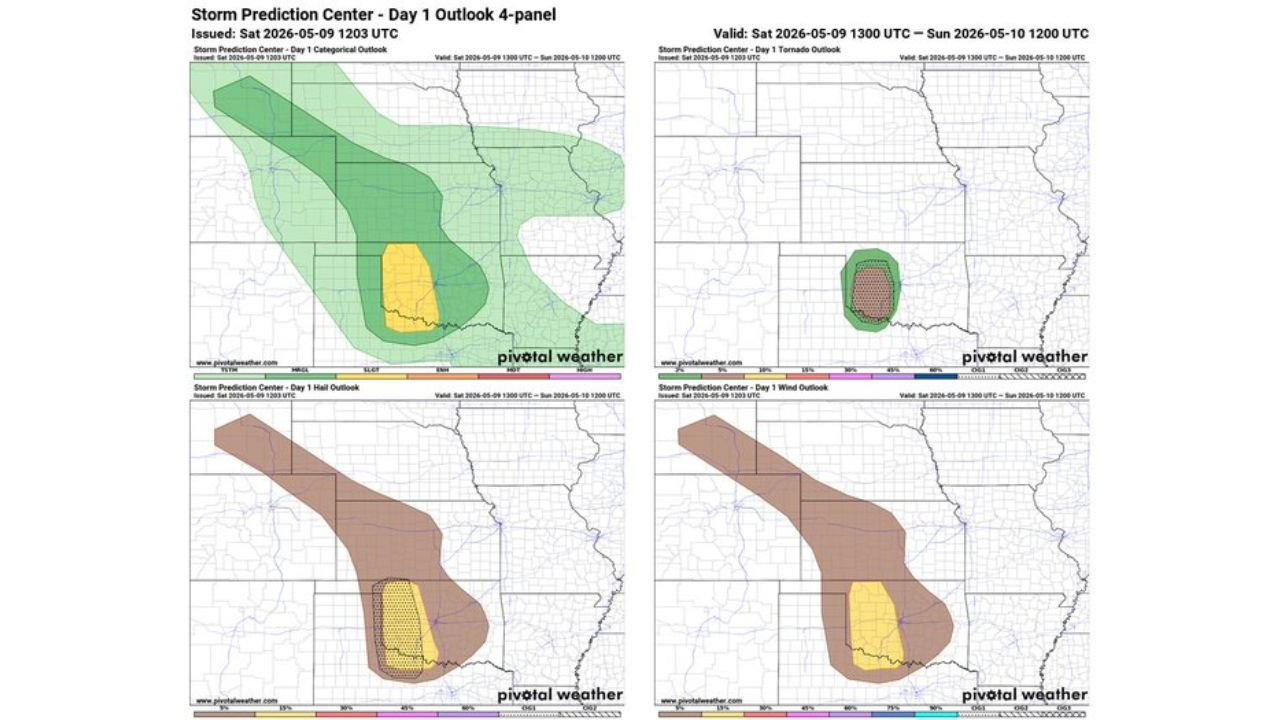
The Four-Panel Outlook in Detail
The SPC Day 1 four-panel valid Saturday May 9, 1300 UTC through Sunday May 10, 1200 UTC shows:
- Categorical — Slight Risk centered over Oklahoma and northwest Texas with broader Marginal Risk
- Tornado — Defined tornado probability zone with a hatched area indicating the 10 percent or greater tornado probability zone
- Hail — Broad hail probability area with a hatched significant hail zone indicating 2-inch or larger hail probability
- Wind — Broad wind probability area with a hatched significant wind zone indicating 75 MPH or greater wind gusts possible
Cities and Areas to Watch Saturday
Based on the updraft helicity forecast and risk zone placement, the areas of greatest concern for Saturday’s severe weather include:
- Memphis, Texas — highest helicity values on the forecast map
- Altus, Oklahoma — secondary helicity concentration
- Lawton, Oklahoma — within the elevated storm environment
- Woodward, Oklahoma — northern edge of the active zone
- Paducah and Haskell, Texas — within the storm corridor
Timing of the Threat
Storms are expected to develop and become most active during the late afternoon and evening hours on Saturday, with the peak threat window focused around the 9:00 PM CDT timeframe based on the helicity and storm environment forecasts.
Stay with CabarrusWeekly.com for continuing updates on Saturday’s severe weather threat across Oklahoma and northwest Texas.