Illinois, Missouri and Indiana Face Severe Winds, Very Heavy Rain and Isolated Tornadoes Monday May 18 as Storm Line Pushes Northeast Into Indiana by Mid-Afternoon Including St. Louis, Chicago and Indianapolis
ST. LOUIS, Missouri – A fast-moving line of storms is pushing northeast this Monday morning, May 18, bringing gusty winds, very heavy rain and isolated tornadoes along its leading edge. The storm line will work into Indiana by mid-afternoon and continue through the evening hours, with severe winds and isolated tornadoes the primary concerns as the system pushes through Illinois, Missouri and Indiana today.
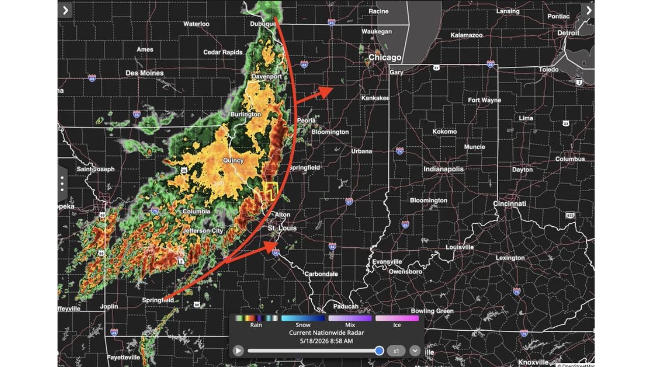
Where the Storm Line Is Right Now
As of 8:58 AM Monday, May 18, the storm line is actively moving northeast and is currently impacting the following communities:
- St. Louis, Alton, Columbia and Jefferson City, Missouri are along or near the leading edge of the storm line this Monday morning, facing gusty winds and very heavy rain right now.
- Quincy, Springfield, Bloomington, Peoria and Davenport, Illinois are within or approaching the leading edge of the storm system as it pushes northeast this morning.
- Burlington and Dubuque, Iowa are on the northern end of the storm line currently pushing northeast on Monday morning, May 18.
Indiana Faces the Storm Mid-Afternoon Through Evening
The storm line is expected to reach Indiana by mid-afternoon Monday, May 18 and push through the state into the evening hours. Communities across Indiana that need to be prepared before the line arrives include:
- Indianapolis, Indiana will see the storm line arrive during mid-afternoon Monday with severe winds and isolated tornadoes possible along the leading edge as it pushes through.
- Fort Wayne, Kokomo, Muncie, Bloomington and Evansville, Indiana are all in the path of the advancing storm line and should expect severe conditions through the Monday afternoon and evening hours.
- Gary and Kankakee, Illinois sit just west of Indiana and will see the leading edge push through before the system crosses the state line Monday afternoon.
Two Main Threats Along the Leading Edge
The most dangerous conditions will be found right along the leading edge of this storm line as it pushes northeast through Illinois, Missouri and Indiana today:
- Severe winds are the primary threat along the leading edge, capable of downing trees and power lines across a wide swath of Illinois and Indiana through this afternoon and evening.
- Isolated tornadoes are possible along the leading edge as the line pushes northeast, requiring residents across Indianapolis, Fort Wayne, Kokomo and Evansville to have a shelter plan ready before the storms arrive mid-afternoon.
- Very heavy rain will accompany the system and could cause localized flooding across Missouri, Illinois and Indiana through Monday evening.
Timing Is Critical for Indiana Residents
The mid-afternoon arrival of this storm line in Indiana means the dangerous window aligns directly with school dismissal and rush hour across Indianapolis and surrounding communities. Do not allow children to wait outside during dismissal if severe warnings are active. Drivers should pull off roads and seek shelter in a sturdy building if the storm line reaches their location while commuting Monday afternoon.
WaldronNews.com will continue tracking this storm line across Illinois, Missouri and Indiana and will provide updates as severe wind reports, tornado activity and heavy rain impacts develop throughout Monday afternoon and evening, May 18.