Maryland, Virginia and Washington DC Face Record Breaking Heat With 95 to 96 Degree Highs Monday Through Wednesday May 18 to 20 as First Heat Wave of 2026 Arrives
WASHINGTON, DC – The first heat wave of 2026 has arrived across the Washington DC, Maryland and Virginia region, with temperatures of 95 to 96 degrees forecast through Wednesday, May 20 and multiple daily heat records likely to fall over the next 3 days. Washington Dulles International Airport is expected to break records on all three days, while Baltimore and DC records are in serious jeopardy through Wednesday.
Record Temperatures at Risk Each Day
The following records are under threat through Wednesday, May 20:
Monday, May 18:
- Washington Dulles International Airport: Record high of 91 degrees set in 1987 is likely to fall today with a forecast high of 95 degrees.
- Washington DC’s all-time record high of 96 degrees set in 1877 for Monday is considered probably safe today.
- Baltimore’s records of 97 degrees Monday and 98 degrees Tuesday, both set in 1962, will also probably hold.
Tuesday, May 19:
- Washington Dulles International Airport: Record high of 92 degrees set in 1997 is likely to fall with a forecast high of 96 degrees Tuesday.
- Washington DC: Record high of 96 degrees set in 1997 is in jeopardy Tuesday with temperatures forecast to reach 96 degrees.
- DC and Dulles could also set record warm overnight lows Tuesday morning, with records to beat of 72 degrees in DC from 2015 and 66 degrees at Dulles from 2017.
Wednesday, May 20:
- Washington Dulles International Airport: Record high of 93 degrees set in 1996 is likely to fall with a forecast high of 95 degrees Wednesday.
- Baltimore: Record high of 95 degrees set in 1962 is in jeopardy Wednesday, May 20.
- Washington DC: Record high of 96 degrees set in 1996 is in jeopardy Wednesday, May 20.
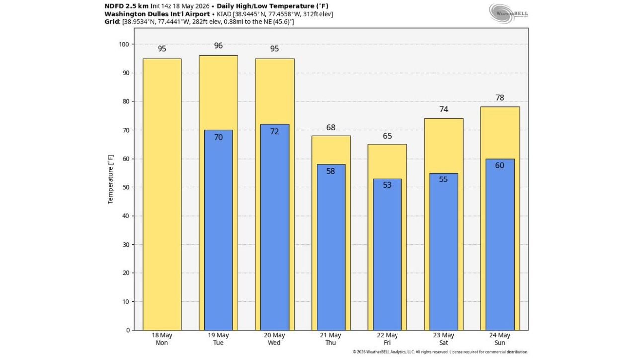
The Full 7 Day Temperature Forecast for Dulles
The forecast for Washington Dulles International Airport through Sunday, May 24 shows a dramatic temperature crash after the heat wave peaks:
- Monday, May 18: High 95 degrees, Low 70 degrees
- Tuesday, May 19: High 96 degrees, Low 72 degrees
- Wednesday, May 20: High 95 degrees, Low 72 degrees
- Thursday, May 21: High 68 degrees, Low 58 degrees
- Friday, May 22: High 65 degrees, Low 53 degrees
- Saturday, May 23: High 74 degrees, Low 55 degrees
- Sunday, May 24: High 78 degrees, Low 60 degrees
What Three Consecutive Days of 95 Plus Degree Heat Means
Three consecutive days of 95 degree or higher temperatures constitute a dangerous heat event for the DC, Maryland and Virginia region. Heat exhaustion and heat stroke become serious risks for elderly residents, outdoor workers, young children and anyone without access to air conditioning. Overnight lows staying at 70 to 72 degrees through Wednesday morning provide no relief for the body to recover from daytime heat stress. This combination of extreme daytime highs and warm overnight lows is what makes multi-day heat waves medically dangerous.
What You Should Do Through Wednesday May 20
Limit all outdoor activity during peak heat hours of noon to 6:00 PM through Wednesday, May 20 across Washington DC, Maryland and Virginia. Drink water consistently even if you do not feel thirsty. Check on elderly neighbors and family members who may not have air conditioning. Never leave children or pets in a parked vehicle under any circumstances during this heat wave.
WaldronNews.com will continue tracking this record-threatening heat wave across Washington DC, Maryland and Virginia and will provide updates as temperature records fall and heat impacts develop through Wednesday, May 20.