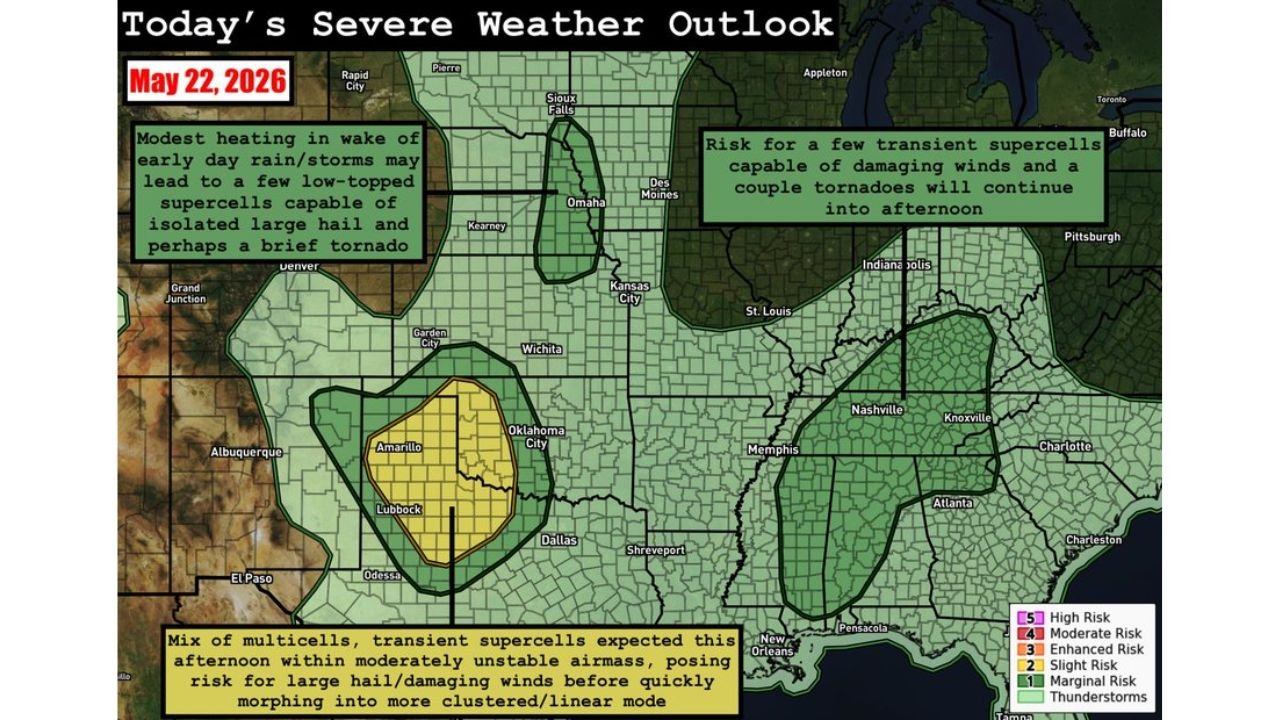
West Texas and Western Oklahoma Face Large Hail and Damaging Winds Friday May 22 While Eastern Nebraska, Tennessee, and the Southeast Battle Tornadoes and Supercells Throughout the Day
UNITED STATES — Three separate areas of severe weather are active across the country on Friday, May 22, 2026, with the most organized threat centered on west Texas and western Oklahoma under a Slight Risk designation, while eastern Nebraska and the Southeast and Mid-South face independent tornado and supercell threats throughout the day.
West Texas and Western Oklahoma: The Primary Severe Weather Zone
The Slight Risk zone is focused on the west Texas and western Oklahoma corridor, covering the area around Amarillo, Lubbock, Oklahoma City, and Wichita. A mix of multicells and transient supercells is expected to develop this afternoon within a moderately unstable airmass, posing the primary threats of large hail and damaging winds before storms quickly transition into a more clustered and linear configuration by evening. Residents in this zone should be weather-aware throughout the afternoon hours.
Eastern Nebraska: Low-Topped Supercells With Hail and Tornado Risk
A separate and independent threat is developing across eastern Nebraska, where modest heating in the wake of early day rain and storms may generate a few low-topped supercells capable of producing isolated large hail and a brief tornado this afternoon. This is a cold-core-esque storm regime, which can produce quick-hitting and difficult-to-track supercells. Communities near Omaha and Kearney should monitor conditions through the afternoon.
Southeast and Mid-South: Tornado Warnings Already Issued This Morning
The Southeast and Mid-South have already seen tornado warnings issued this morning, and the threat is not over. Transient supercells capable of damaging winds and a couple of tornadoes will continue pushing through the region into the afternoon hours. The active corridor covers:
- Memphis, Tennessee
- Nashville and Knoxville, Tennessee
- Charlotte, North Carolina
- Atlanta, Georgia
- Pensacola, Florida
- New Orleans, Louisiana
- Charleston, South Carolina
Full Risk Zone Summary for Friday May 22
| Risk Level | Coverage |
|---|---|
| Slight (2/5) | West Texas and western Oklahoma |
| Marginal (1/5) | Eastern Nebraska and Southeast/Mid-South corridor |
| Thunderstorms | Wide national coverage |
Three Regions, Three Separate Plans Needed
Each of the three active threat zones today requires its own level of awareness. West Texas and Oklahoma residents should watch for large hail and damaging wind-producing supercells this afternoon. Eastern Nebraska should stay alert for brief tornadoes from low-topped storms. And the entire Southeast and Mid-South corridor must remain on high alert as tornado-warned supercells continue tracking through the region into the afternoon.
Stay with CabarrusWeekly.com for live severe weather updates across all three threat zones throughout Friday.