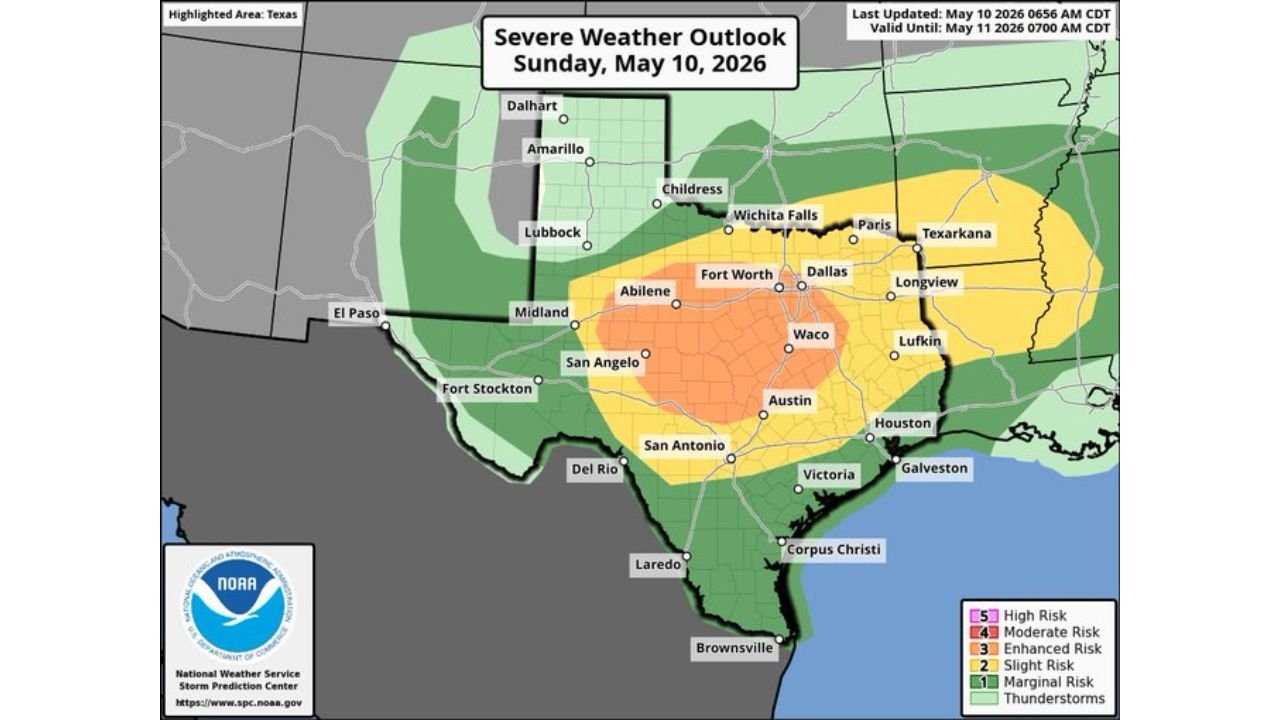
Abilene, Waco, Austin, San Angelo, and Fort Worth Face Intense MCS With Hurricane Force Wind Gusts and Very Large Hail on Mother’s Day Sunday May 10
TEXAS — An intense Mesoscale Convective System is expected to develop and move south across Texas on Sunday, May 10, 2026, with initial discrete supercells forecast to fire near the I-20 corridor around midday to early afternoon. The Storm Prediction Center has outlined an Enhanced Risk Level 3 of 5 centered over a broad zone covering Abilene, Waco, Austin, San Angelo, and Fort Worth, with hurricane-force wind gusts possible as the storm system organizes into a robust and extensive MCS through the afternoon and evening.
How the Storm Evolves Sunday
The severe weather event Sunday unfolds in two distinct phases:
Phase 1 — Midday to Early Afternoon Initial discrete supercells fire near the I-20 corridor and produce:
- Large to very large hail
- Damaging winds
This supercell phase will be relatively short-lived as storms quickly congeal into an organized MCS.
Phase 2 — Afternoon Through Evening Storms rapidly consolidate into a robust and extensive MCS moving southward across Texas, bringing:
- Significant damaging wind threat
- Hurricane-force wind gusts possible
- Extremely low tornado threat due to lack of low-level shear and unfavorable storm mode
The Risk Zones for Sunday May 10
| Risk Level | Cities Included |
|---|---|
| Enhanced Risk Level 3 of 5 | Abilene, San Angelo, Waco, Austin, and surrounding corridor |
| Slight Risk Level 2 of 5 | Fort Worth, Dallas, Wichita Falls, Lufkin, Houston, San Antonio, Victoria |
| Marginal Risk Level 1 of 5 | Amarillo, Lubbock, Childress, Paris, Texarkana, Longview, Galveston, Corpus Christi |
Hazards Expected Sunday
| Threat | Status |
|---|---|
| Hurricane-force Wind Gusts | Primary threat with MCS phase |
| Very Large Hail | Primary threat during supercell phase near I-20 |
| Damaging Winds | Widespread with MCS |
| Tornado | Extremely low threat |
Timing of the Threat Sunday
The most dangerous window begins around midday as supercells initiate near the I-20 corridor across central Texas. Storms are expected to quickly organize into the MCS structure through the early to mid afternoon hours, with the damaging wind threat from the MCS continuing to push southward through the afternoon and evening.
What Texas Residents Must Do Sunday
Anyone across Abilene, Waco, Austin, San Angelo, and Fort Worth inside the Enhanced Risk zone should treat Sunday as a dangerous weather day. The hurricane-force wind gusts possible with the MCS phase represent a serious threat to structures, trees, and power lines across a wide area of central Texas.
- Secure all outdoor furniture and loose objects before midday
- Have multiple ways to receive warnings
- Be prepared for power outages across the Enhanced Risk corridor
- Avoid travel during the peak MCS wind threat
Stay with CabarrusWeekly.com for continuing live updates on Sunday’s Mother’s Day severe weather outbreak across Texas.