Northern Canada Blocking High Cuts Off Midwest Rain and Builds Heat and Drought Risk Across North Dakota, South Dakota, Nebraska, and the Northern Plains to Close May and Start June
UNITED STATES — A substantial blocking high pressure system anchoring over Northern Canada is set to dramatically reshape the weather pattern across the central United States as May closes and June begins, cutting off meaningful rain chances for the Midwest while building hot and dry conditions across the Northern Plains in a setup forecasters are comparing directly to early June 2023.
What the Upper Level Pattern Shows for May 30 Through June 4
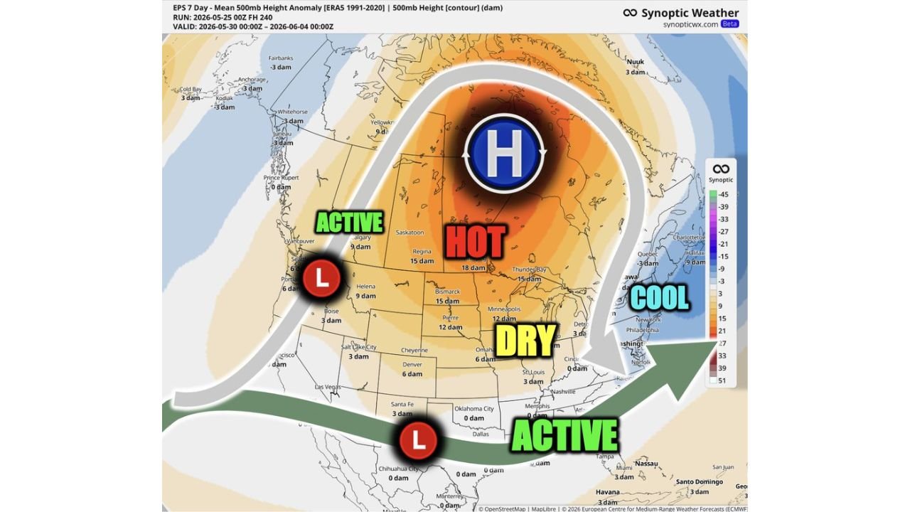
The EPS 7-day mean 500mb height anomaly run initialized at 00z May 25, 2026, valid from May 30 through June 4, 2026, shows a textbook blocking pattern dominating the continent.
Upper level pattern breakdown by zone:
| Zone | Condition | Height Anomaly | Key Areas |
|---|---|---|---|
| Northern Canada | Blocking High (H) | Strongly positive | Dominant feature of the pattern |
| Canadian Prairies / Regina area | Hot | 15 to 18 dam above normal | Saskatoon, Regina, Thunder Bay |
| Northern Plains / Upper Midwest | Dry | 6 to 15 dam above normal | Bismarck, Pierre, Omaha, Minneapolis |
| Pacific Northwest | Active, Low pressure | Negative anomaly | Vancouver, Portland area |
| Southern U.S. / Gulf Coast | Active | Near to below normal | Memphis, Dallas corridor |
| Northeast / Mid-Atlantic | Cool | Negative anomaly | New York, Philadelphia, Washington |
Why This Pattern Cuts Off Midwest Rain
The blocking high over Northern Canada acts as a wall in the atmosphere, redirecting storm systems away from the Midwest and Northern Plains. This is the critical mechanism behind the coming dry stretch.
How the block affects each region:
- Midwest loses its pipeline of storm systems as the block deflects energy north and south
- Northern Plains sits directly under the hot and dry dome building beneath the Canadian high
- Storm track shifts to the Pacific Northwest on the west side and the Gulf Coast on the south
- Notable rain risks are cut off across the Midwest for the close of May and start of June
- Active weather zones are pushed to the Pacific Coast low and the southern U.S. low, bypassing the central Plains
A Very Similar Setup to Early June 2023
Forecasters are drawing a direct comparison to early June 2023, describing the current pattern as a very similar setup to what produced hot and dry conditions across the region during that period. The blocking high configuration, the placement of the dry zone beneath it, and the deflection of storm tracks are all closely mirroring that historical analog.
This comparison carries significance for agricultural and drought planning, as the June 2023 pattern was associated with expanding dryness across the Northern Plains.
Drought and Abnormally Dry Conditions Likely to Expand
The combination of heat building beneath the blocking high and the absence of meaningful rainfall creates a direct drought development risk across the Northern Plains.
Drought risk outlook:
| Area | Risk Level |
|---|---|
| Northern Plains (North Dakota, South Dakota) | High risk of expanding drought |
| Nebraska / Kansas border region | Abnormally dry conditions likely |
| Upper Midwest (Minnesota, Iowa) | Drying trend, reduced rain chances |
| Canadian Prairies | Already under hot and dry pattern |
Forecasters are specifically flagging that expanding drought and abnormally dry conditions are likely, especially across the Northern Plains, if this pattern holds through the first days of June as currently modeled.
A Welcome Window for Planting and Field Work
Despite the drought development concerns, the dry pattern does carry one significant benefit for the agricultural community.
Agricultural outlook for Midwest to Northern Plains:
- Favorable conditions for finishing planting across areas that have been too wet
- Field work windows open as rain chances drop through late May and early June
- Soil trafficability improves quickly under a hot and dry pattern
- Producers needing dry days to complete spring operations will find them during this window
- Drought risk builds quickly if the pattern extends beyond the early June window without a break
What Each Region Should Expect
Northern Plains including North Dakota, South Dakota, Nebraska: Expanding heat, drying soils, and drought development risk increase through the first week of June. Rain chances minimal.
Midwest including Minnesota, Iowa, Illinois, Missouri: Reduced storm chances through the late May and early June window as the block cuts off the normal storm track. A drying trend develops even if full drought does not establish immediately.
Pacific Northwest: Active weather continues with the western low pressure system keeping storm chances alive along the coast.
Southern United States: The southern low keeps active weather possible across the Gulf Coast states and into the Southeast through the same period.
Stay with CabarrusWeekly.com for continuing updates on the evolving early June pattern and drought risk across the Northern Plains and Midwest.