Fast-Moving Snow Band Targets Northern Illinois and Northwest Indiana Tonight, Dropping Up to 1 Inch With Sudden Whiteouts
NORTH CAROLINA — A fast-moving band of locally intense snow showers is expected to race across parts of Illinois and Indiana late tonight into the early overnight hours, creating a quick-hit winter hazard that can turn roads slick and visibility dangerously low in a matter of minutes.
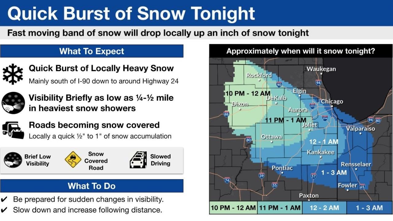
The National Weather Service outlook highlights brief but heavy bursts of snow capable of dropping a quick half inch to locally one inch—not a major storm by totals, but enough to cause sudden travel problems during the late-night window when roads may cool and untreated surfaces can ice up.
Sudden Whiteouts and Snow-Covered Roads Are the Main Risk
This setup is all about intensity over duration. Forecasters are calling for visibility briefly as low as 1/4 to 1/2 mile in the heaviest snow showers—conditions that can feel like an instant “curtain” on highways and interstates.
Drivers in the path of the band should expect:
- Rapid visibility drops during the heaviest bursts
- Roads becoming snow covered quickly, even if pavement looked fine earlier
- Slower travel and higher crash risk during the narrow window of peak snow
The Heaviest Burst Focuses South of I-90 Down Toward Highway 24
The highest-impact zone is expected mainly south of I-90 down to around Highway 24, placing a wide stretch of northern Illinois and portions of northwest Indiana in the corridor for the quickest accumulation and sharpest visibility reductions.
Communities close to or within the band’s track include areas near Rockford, DeKalb, Elgin, Aurora, Joliet, and Chicago—with impacts later pushing toward northwest Indiana locations such as Valparaiso.
Timing Window Shows the Snow Band Sweeping West to East Overnight
The forecast timing is staggered by location, with the band progressing across the region in phases:
- 10 PM to 12 AM: Snow develops across far northern Illinois, including the Rockford area and nearby communities
- 11 PM to 1 AM: The band shifts east and southeast, affecting locations around DeKalb, Aurora, Joliet, and Ottawa
- 12 AM to 2 AM: Snow reaches the Chicago metro corridor and surrounding areas
- 1 AM to 3 AM: The snow band pushes into northwest Indiana, including areas near Valparaiso and points farther southeast
Because the snow is expected to be fast-moving, any one location may only experience the worst conditions for a short time—but that short time can be exactly when people are still commuting late, driving home, or traveling overnight.
What Drivers Should Do If You’re Traveling Through the Region Tonight
Even a “quick burst” can be enough to cause multi-car wrecks when visibility collapses and braking distance suddenly changes. If you or family members are traveling through northern Illinois or northwest Indiana tonight:
- Be prepared for sudden changes in visibility
- Slow down and increase following distance, especially on bridges, ramps, and untreated secondary roads
CabarrusWeekly.com is tracking winter patterns nationwide because they often preview how quick-hitting bands can behave in other regions too—have you seen sudden whiteout-style snow bursts where you live, or are you traveling through the Midwest tonight? Share what you’re seeing with CabarrusWeekly.com.