Sneaky Snow Band Could Drop 4–5 Inches Between NYC and Boston Early Saturday, With Hartford–Providence Corridor Most at Risk
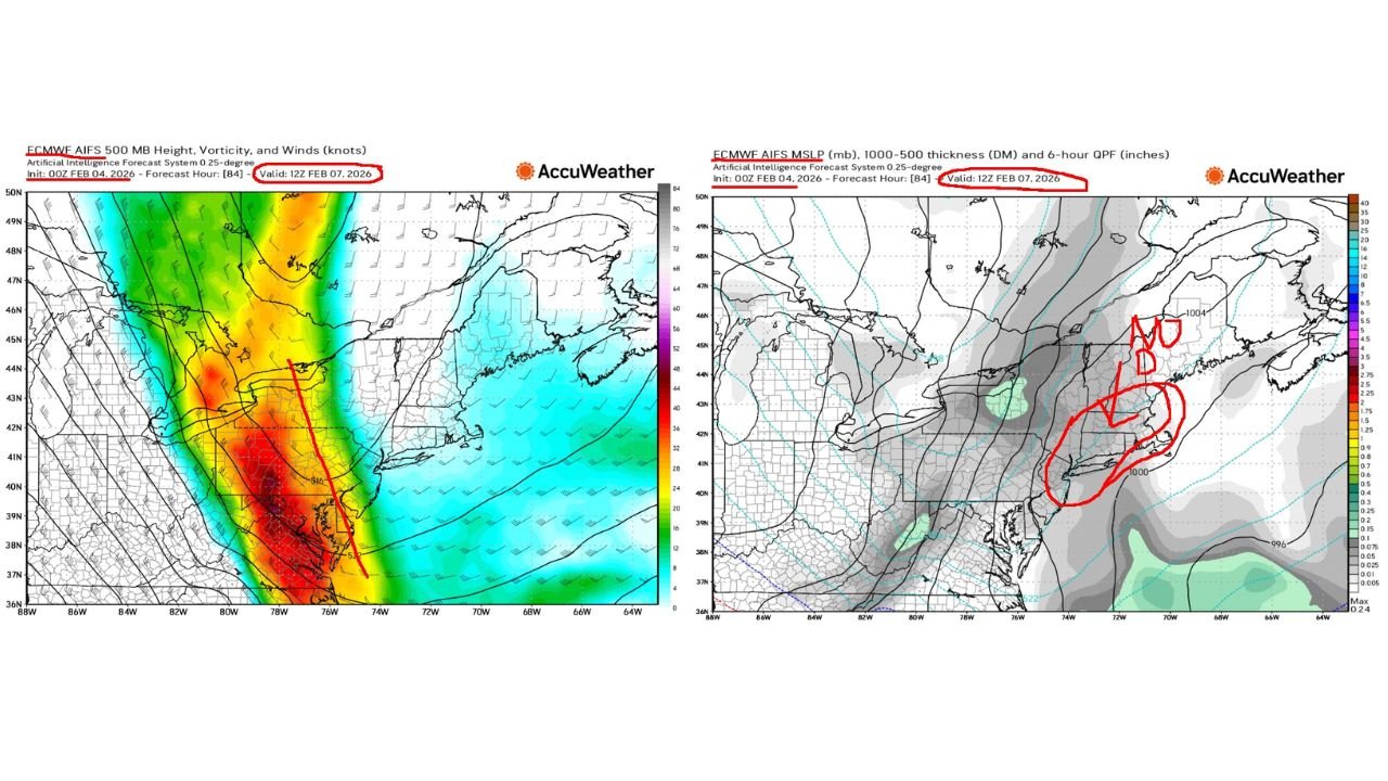
NORTH CAROLINA — A “sneaky” snow setup is taking shape for parts of the Northeast late Friday night into Saturday morning, with forecast signals pointing to a very small, high-impact band capable of dropping 4 to 5 inches somewhere between New York City and Boston—most likely near the Hartford (HFD) to Providence (PVD) corridor if the band locks in the way current guidance suggests.
This is not a broad, all-day nor’easter type event. It’s the kind of narrow, fast-developing band that can leave one area with a quick plowable snowfall while towns 20–40 miles away get far less.
The Setup: A Narrow Band With a “Jackpot” Zone
Model maps shared for 12Z Saturday, Feb. 7, 2026 show a compact system sliding through southern New England with ingredients that can favor a sudden burst of snow:
- A negative-tilt trough signal (a more favorable orientation for lift and banding)
- Good upward motion noted in the discussion
- Low thickness values, supporting colder column temperatures and a better chance for all snow
- Potential for higher snow ratios, meaning fluffier snow that accumulates efficiently
The key point repeated in the update is that this would be a VERY SMALL bullseye if it happens—more like a stripe than a blanket.
Timing: Late Friday Night Into Saturday Morning
The most likely window highlighted is Friday night into early Saturday, which is often when these narrow features can surprise travelers because roads may go from wet to snow-covered quickly while visibility drops under heavier bands.
If the band develops as shown, snowfall rates could spike for a short time—enough to create slick highways and secondary roads in the corridor between NYC and Boston.
The Most Likely Target: Hartford to Providence, But Confidence Is Still Limited
While the discussion leans toward a zone between Hartford (Connecticut) and Providence (Rhode Island) as the most likely area for the 4–5 inch “jackpot,” it also stresses uncertainty.
That’s typical for this type of event. With a narrow band, a small shift in track can move the best snow:
- Farther north toward parts of central Massachusetts
- Farther south closer to coastal Connecticut/Rhode Island
- Or weaken the band enough that the “jackpot” never truly materializes
In other words, the ingredients look supportive, but placement is still a moving target.
Why This Is Being Called “Sneaky”
This setup earns the “sneaky” label because it doesn’t need a big storm system to create big local problems. A thin stripe of heavy snow can:
- Create sudden whiteout bursts
- Produce a quick 4–5 inch accumulation in a small area
- Catch commuters off-guard because surrounding towns may barely see impacts
These are the events that make highway conditions look “fine” on one side of a metro area and “snow covered” on the other.
What Cabarrus County Readers Should Know
This snow threat is centered well north of North Carolina, but it matters for Cabarrus County families in two common ways:
- Travel connections: If you have flights, train trips, or driving plans tied to NYC, Hartford, Providence, or Boston late Friday into Saturday, even a small band can cause delays—especially if it hits near airports or major interstates.
- Pattern awareness: The broader theme this week has been an active, cold-leaning pattern across parts of the East. That can keep winter hazards popping up in narrow windows, even when the “big storm” headlines aren’t there.
What To Watch Next If You’re Traveling Into the Northeast
Because the likely heavy snow zone is so small, the next round of updates should focus on:
- Whether the band trend shifts north or south
- If snow ratios truly run higher (supporting quicker accumulation)
- Any expansion in coverage from “very small” to “more widespread”
If you’ve got family in the NYC–Boston corridor or you’re traveling that direction this weekend, keep an eye on late Friday night updates and road conditions early Saturday morning.
CabarrusWeekly.com will continue tracking these quick-hit winter setups that can cause outsized travel problems. If you’re traveling into the Northeast this weekend, tell us where you’re headed and what conditions look like in your destination area.