February Warm Pattern Expands Across North Carolina, South Carolina, Georgia and Virginia as Mid-Month Cold Signal Fades
NORTH CAROLINA — New temperature anomaly guidance for mid-February shows a continued warm pattern across much of the eastern and central United States, with North Carolina firmly positioned inside an above-average temperature zone and no strong signal for a sustained cold outbreak as February progresses.
Temperature Anomalies Favor Warmth Across the Carolinas
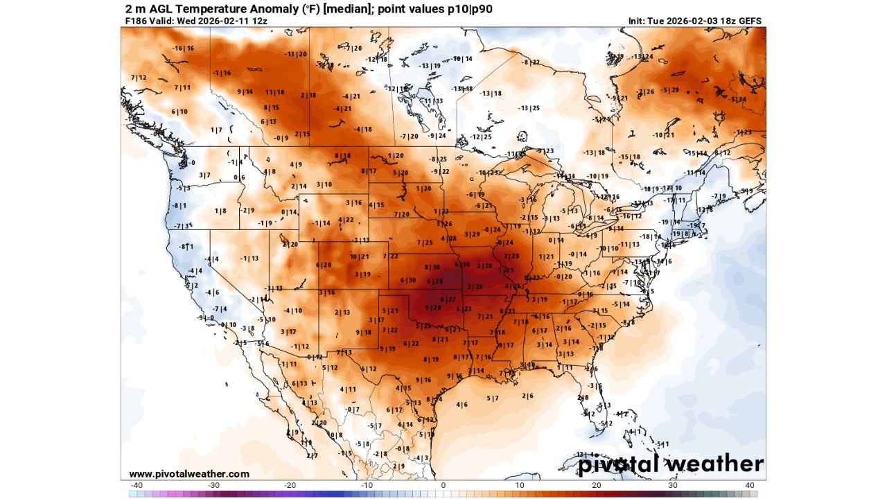
The 2-meter temperature anomaly data valid for Wednesday, February 11 indicates above-normal temperatures covering most of North Carolina, including the Piedmont region where Cabarrus County is located.
Across the state, forecast anomalies generally range from several degrees above average, signaling a pattern that favors mild daytime highs and fewer prolonged cold stretches. Similar warmth extends south into South Carolina and Georgia, reinforcing a broader Southeast-wide trend rather than a localized event.
Virginia, Tennessee and the Southeast Also Trending Above Normal
The warm signal does not stop at the Carolinas. Forecast data shows Virginia and Tennessee also sitting on the warmer side of the pattern, suggesting the Southeast as a whole is likely to experience a milder-than-normal mid-February period.
This widespread coverage reduces the likelihood of a strong Arctic air mass pushing deep into the region, as cold air typically requires a broader regional setup to sustain itself across multiple states.
Central United States Shows Strongest Warm Anomalies
The most pronounced warmth on the map is centered over the central Plains and Midwest, including Missouri, Arkansas, Kansas, Iowa and Illinois, where temperature anomalies are significantly above seasonal averages.
This strong central warmth helps reinforce downstream ridging, which in turn supports continued mild conditions across eastern states such as North Carolina, South Carolina and Georgia.
Northern Tier Holds the Coldest Air — But It Stays North
Colder-than-average air remains largely confined to parts of Canada and the far northern tier of the United States, including areas near the Great Lakes and northern New England.
However, the data shows no meaningful southward penetration of that cold air into the Carolinas or the deeper Southeast during this timeframe, limiting the risk of widespread winter cold reaching North Carolina.
Polar Vortex Changes Reduce Mid-February Cold Potential
Notes accompanying the forecast guidance indicate that recent model shifts involving the polar vortex have reduced confidence in a major mid-February cold event.
Earlier expectations of stronger cold opportunities have faded, with current data favoring a warmer and more stable pattern for most of the United States, including the Southeast.
What This Means for North Carolina Residents
For residents across North Carolina, including Cabarrus County, this pattern suggests:
- More days with above-average temperatures
- Shorter and weaker cold fronts
- Limited risk of prolonged freezes
- Greater day-to-day temperature consistency
While brief cool downs are still possible, the overall setup favors milder conditions rather than classic winter cold through at least the middle of February.
Pattern Could Still Change Later in the Month
It’s important to note that February is not over, and late-month pattern shifts remain possible. However, based strictly on the current data, there is no strong signal pointing toward a significant cold outbreak impacting North Carolina or neighboring states in the near term.
As always, Cabarrus Weekly will continue monitoring updates to see whether colder air begins showing up in later model runs.
Are you noticing milder mornings or warmer afternoons where you live in North Carolina? Share what you’re seeing locally and keep following CabarrusWeekly.com for the latest weather updates.