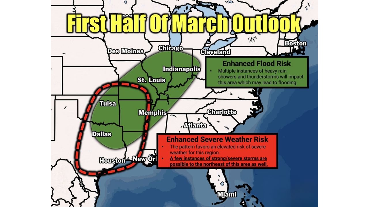
Active Early March Pattern to Bring Flooding From Texas to Ohio and Rising Severe Storm Threat Across the South-Central U.S.
UNITED STATES — The first half of March is shaping up to be highly active across a large stretch of the country, with flooding risks expanding from Texas through the Mississippi Valley into Ohio, while severe weather threats ramp up across the South-Central U.S.
Forecast guidance highlights repeated rounds of heavy rainfall and thunderstorms that could lead to rising water concerns in multiple states.
Enhanced Flood Risk From Texas to Ohio
A broad corridor stretching from eastern Texas through Arkansas, Missouri, Illinois, Indiana, and into Ohio is under an enhanced flood risk outlook.
Cities within or near this zone include:
- Houston
- Dallas
- Tulsa
- Memphis
- St. Louis
- Indianapolis
- Cleveland
Forecasters warn that multiple instances of heavy rain and thunderstorms may impact this region over several days, increasing the potential for:
- Flash flooding in urban areas
- River rises along major waterways
- Saturated ground conditions
The repeated nature of rainfall events is a key concern, as soils may not have sufficient time to dry between systems.
Severe Weather Risk Elevated in South-Central U.S.
At the same time, a concentrated severe weather zone is highlighted across parts of:
- Eastern Texas
- Louisiana
- Arkansas
- Oklahoma
- Western Mississippi
The evolving pattern favors an elevated risk of strong to severe thunderstorms in this region.
While the core severe risk is centered over the South-Central states, forecasters note that a few instances of strong or severe storms could extend northeastward toward the Mid-Mississippi and Ohio Valleys as systems progress.
Why the Pattern Is Turning Active
The setup suggests a storm track repeatedly ejecting systems from the southern Plains toward the Midwest and Ohio Valley.
This type of configuration can:
- Draw Gulf moisture northward
- Fuel thunderstorms and heavy rainfall
- Create overlapping precipitation zones
When moisture-rich air collides with lingering frontal boundaries, rainfall efficiency increases, raising flood concerns.
What Residents Should Watch
Residents from Texas to Ohio should monitor:
- Local rainfall totals and forecasts
- River stage updates
- Severe thunderstorm outlooks
Those in the South-Central U.S. should also remain alert for:
- Damaging wind potential
- Large hail
- Isolated tornado threats
As with all extended outlooks, specific timing and placement will become clearer in the coming days, but confidence is growing that early March will bring an active and potentially impactful weather pattern.
Stay with CabarrusWeekly.com for continued updates as the first half of March unfolds across the central and eastern United States.