Georgia, South Carolina, North Carolina and Florida Facing Expanding Drought as Southeast Stays Dry Until Late April Rain Chances Return
UNITED STATES — A concerning dry pattern continues to grip the southeastern United States, with drought conditions expanding across states like Georgia, South Carolina, North Carolina, Alabama, and Florida, and little to no meaningful rainfall expected in the short term.
Southeast Stuck in a Dry Pattern Through Mid-April
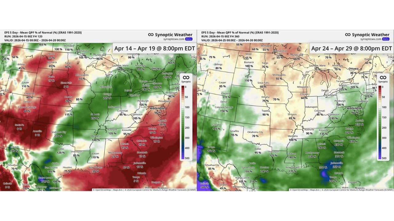
Latest forecast data shows a stark contrast across the country. While the Midwest and parts of the Plains are seeing above-normal rainfall, the Southeast is firmly locked into a below-average precipitation pattern.
From Atlanta to Charlotte, Raleigh, Savannah, Jacksonville, and Orlando, rainfall totals over the next several days are expected to remain well below normal, with many areas seeing only 10% to 25% of typical precipitation levels.
This lack of rainfall is not just a short-term issue. It is part of a broader pattern driven by persistent high pressure, which continues to block storm systems from reaching the region.
Drought Conditions Already Worsening Across Multiple States
The ongoing dryness is already taking a toll. Across much of the Southeast:
- Soil moisture levels are declining rapidly
- Streams and reservoirs are under increasing stress
- Vegetation is drying out earlier than normal
States like Georgia, South Carolina, and parts of Florida are seeing some of the most pronounced impacts, where drought conditions are spreading and intensifying.
With above-average temperatures also in play, the situation is expected to worsen more quickly, increasing concerns about early-season wildfire risk and agricultural stress.
Nationwide Contrast: Wet Midwest vs Dry Southeast
While the Southeast dries out, the central U.S. is experiencing the opposite trend.
Forecast maps show:
- Missouri, Illinois, Indiana, and surrounding areas receiving 150% to 250% of normal rainfall
- Portions of the Southern Plains and Texas also seeing above-normal precipitation
This sharp divide highlights a classic split weather pattern, where storm systems repeatedly track through the central U.S. but miss the Southeast entirely.
Late April Could Bring Much-Needed Relief
There is some hope on the horizon. Extended-range forecasts indicate that by late April (around April 24–29), the pattern may begin to shift.
During that timeframe:
- Rain chances are expected to increase across the Southeast
- Some areas could see above-normal precipitation, particularly across Alabama, Georgia, and the Carolinas
- Florida may also begin to see more consistent moisture return
However, even with this potential shift, it may take multiple rounds of rain to significantly ease the growing drought conditions.
Why the Delay Matters
The longer the dry pattern persists, the more difficult it becomes to reverse its impacts. Key concerns include:
- Deepening drought levels
- Increased wildfire danger, especially in forested areas
- Agricultural stress heading deeper into the spring season
By the time meaningful rain arrives, some regions may already be dealing with moderate to severe drought conditions.
What Residents Should Expect
For now, residents across the Southeast should prepare for:
- Continued dry and warm conditions through at least mid-April
- Limited chances for meaningful rainfall in the short term
- Increasing need for water conservation and fire awareness
Bottom Line
The Southeast is entering a critical stretch of weather, with Georgia, the Carolinas, Alabama, and Florida facing worsening drought conditions as rainfall remains scarce. While late April may finally bring relief, the next couple of weeks will likely see conditions deteriorate further before improvement begins.
Stay with CabarrusWeekly.com for continued updates as this developing drought situation and shifting weather pattern evolve across the region.