Heavy Rainfall Set to Target Drought-Stricken Red River, Mississippi and Ohio Valleys March 6–10 as Long-Standing Moisture Deficits Face Potential Reversal
UNITED STATES — A large corridor of the country stretching from the Red River region through the Lower and Middle Mississippi Valley and into the lower Ohio Valley may finally see meaningful rainfall relief during the first half of March.
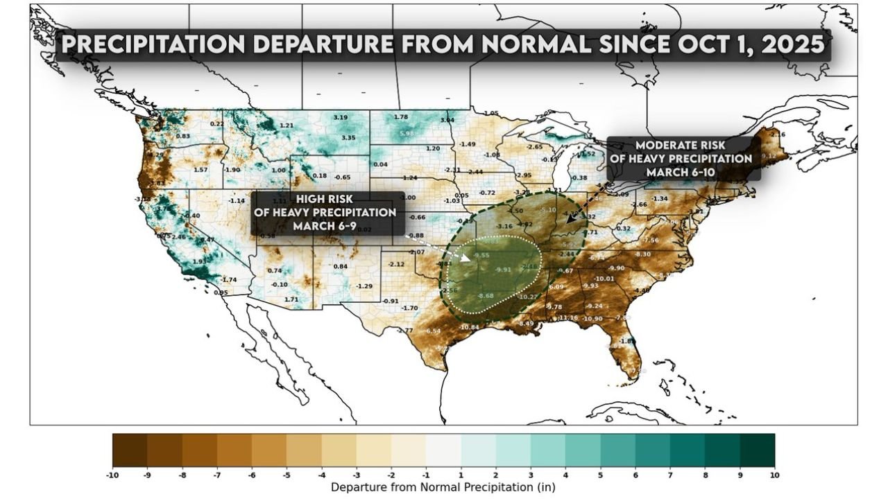
New outlook guidance highlights moderate to high risk areas for heavy precipitation between March 6 and March 10, targeting regions that have experienced significant rainfall deficits since October 2025.
Long-Standing Rainfall Deficits Across the South and Mid-South
Precipitation departure data since October 1, 2025 shows widespread 5 to 10 inch moisture deficits across portions of:
- North Texas and eastern Oklahoma
- Arkansas and Louisiana
- Mississippi and Alabama
- Tennessee and parts of the Ohio Valley
Much of the Deep South and lower Mississippi Valley has been running well below normal, with darker brown shading indicating some of the largest negative departures.
These deficits have raised concerns about soil moisture depletion and increasing drought stress in parts of the region.
March 6–9: High Risk of Heavy Rain from Texas into the Mid-South
The outlook identifies a high risk area for heavy precipitation from March 6 through March 9, centered over:
- North and East Texas
- Southern and eastern Oklahoma
- Arkansas
- Northern Louisiana
This zone overlaps significantly with areas that have been running several inches below normal since autumn.
If forecast rainfall verifies, it could provide a meaningful dent in moisture shortages. However, rapid rainfall over dry ground can also increase runoff concerns if storms become intense.
March 6–10: Moderate Risk Extends into the Ohio Valley and Northeast
Farther northeast, a moderate heavy rain risk for March 6–10 extends through portions of:
- The lower Ohio Valley
- Kentucky and southern Indiana
- Parts of Ohio
- Interior portions of the Northeast
While deficits in these areas are not as extreme as parts of the Deep South, some locations have still been running below seasonal averages.
The broader pattern suggests a storm track capable of producing repeated rounds of precipitation along this corridor.
Relief Possible — But Flooding Concerns Cannot Be Ignored
For drought-affected regions, widespread rainfall would be welcome. The key questions will be:
- How much rain falls in a short period
- Whether storms train repeatedly over the same areas
- How quickly soils can absorb incoming moisture
Areas with deeper deficits may initially absorb rainfall efficiently. However, if heavy rainfall bands persist, localized flooding could still develop, particularly near rivers and urban centers.
What This Means for North Carolina
While the highlighted heavy rain risk zones focus west of the Carolinas, broader pattern changes across the southern United States can influence weather downstream.
A more active storm track across the Lower Mississippi and Ohio Valleys can eventually lead to:
- Increased rain chances across the Southeast
- Stronger frontal systems moving eastward
- Periods of unsettled weather during early to mid-March
At this time, the primary heavy rainfall focus remains west of North Carolina. However, residents of Cabarrus County should remain aware that pattern shifts across the southern Plains often migrate east with time.
We will continue monitoring how this early-March storm track evolves and whether any impacts extend into the Carolinas. Stay tuned to CabarrusWeekly.com for ongoing updates as the March 6–10 timeframe approaches.