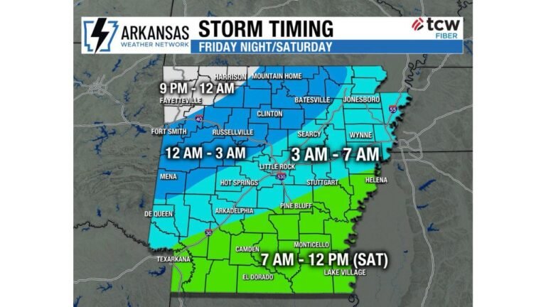
Oklahoma and Texas Bracing for March 4 Severe Weather Threat as Robust Upper-Level Disturbance and Gulf Moisture Combine
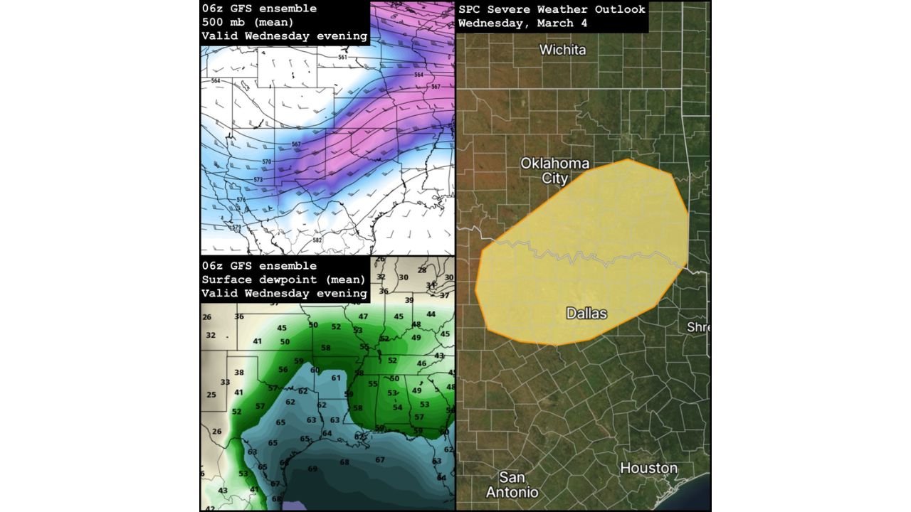
OKLAHOMA AND TEXAS — The Storm Prediction Center has outlined a severe weather threat for Wednesday, March 4, centered on parts of Oklahoma and North Texas, as a strengthening upper-level system interacts with increasing Gulf moisture.
While this setup is well west of North Carolina, it signals the beginning of a more active early March pattern across the southern United States.
SPC Highlights Risk Area Near Oklahoma City and Dallas
The March 4 outlook places a highlighted severe weather area stretching from near Oklahoma City southward toward the Dallas–Fort Worth Metroplex, covering a broad portion of central and eastern Oklahoma into North Texas.
Cities within or near the outlined risk zone include:
Oklahoma City, OK
Dallas, TX
Areas between and surrounding these metro regions may see the greatest storm potential depending on how the system evolves through Wednesday afternoon and evening.
Specific hazards and intensity levels remain uncertain this far out, but the environment is expected to support organized thunderstorms.
Upper-Level Pattern Supports Storm Development
Model ensemble guidance for Wednesday evening shows a robust shortwave disturbance at 500 mb moving across the Southern Plains. This type of feature enhances lift and can strengthen storm organization when paired with favorable surface conditions.
The upper-level wind pattern appears supportive of:
Increasing wind shear
Enhanced storm rotation potential
Organized thunderstorm structures
This upper-level support is one of the key reasons forecasters are watching this setup closely.
Gulf Moisture Returns with Notable Warm Sector
Surface dew point projections indicate a notable warm and moist sector developing across Texas and Oklahoma, with mid-to-upper 50s to low 60s dew points advancing northward into the risk area.
This moisture return from the Gulf of Mexico is critical for fueling stronger thunderstorms.
By Wednesday evening, the combination of:
Rising humidity
Warmer surface temperatures
Strong upper-level forcing
could create a favorable environment for severe storms somewhere within the outlined region.
Timing and Hazard Details Still Unclear
Forecasters emphasize that specific timing, hazards, and intensity are still uncertain. It remains too early to determine whether the primary threat would include damaging winds, large hail, or isolated tornado potential.
As the event approaches, higher-resolution models will better define:
Storm mode (discrete cells vs. line segments)
Peak timing window Wednesday afternoon or evening
Exact placement of the strongest storms
For now, the key takeaway is that this appears to be the first in what could be a more active stretch of early March weather events across the Southern Plains.
What This Means for North Carolina
While this particular severe weather setup is centered over Oklahoma and Texas, broader ensemble guidance suggests a shift toward a more active national weather pattern.
That shift could eventually translate into increased rain and thunderstorm chances across parts of the Southeast later in the first half of March.
Residents in Cabarrus County will want to monitor forecast trends over the coming days, especially as storm systems progress eastward later in the week.
If you have family or travel plans in Oklahoma or Texas this week, stay weather aware and check for updates as March 4 approaches. For local North Carolina updates and regional weather coverage, continue following CabarrusWeekly.com.