North Carolina Swings from 70s Sunday to Cold, Damp Monday–Tuesday with Low-End Icy Mix Risk Monday Night
NORTH CAROLINA — A dramatic temperature swing is on the way as 70-degree warmth Sunday gives way to a cold and damp start to the new week, with some model guidance hinting at a low-end icy mix risk Monday night if temperatures hover near freezing.
This does not look like a major winter storm setup, but the transition will be noticeable — and worth watching.
Sunday: Springlike Warmth Before the Shift
Sunday will feel more like mid-spring than early March across much of the state. Afternoon highs are expected to climb into the:
• Lower 70s
• Possibly mid-70s in warmer spots
Skies will gradually increase in cloud cover late in the day as the next system approaches from the west.
Monday–Tuesday: Cold Air Builds In with Moisture
By Monday, colder air begins filtering into North Carolina and continues through Tuesday. Temperatures are expected to fall sharply compared to Sunday, with highs likely settling into:
• Upper 30s
• Low to mid 40s
The most likely overall scenario includes:
• Cloudy skies
• Chilly daytime temperatures
• On-and-off light rain
This setup favors a raw, damp feel rather than heavy precipitation or widespread winter weather.
Is Winter Weather Likely?
At this time, widespread winter weather appears unlikely. However, there is a narrow window Monday night that bears monitoring.
If temperatures hover around or slightly below 32 degrees while light precipitation continues, some areas could see:
• Patchy freezing drizzle
• A brief light icy mix
• Minor glaze on elevated surfaces such as trees or bridges
This would depend on surface temperatures cooling just enough while moisture lingers. Forecast confidence in this outcome remains low, but it cannot be completely ruled out yet.
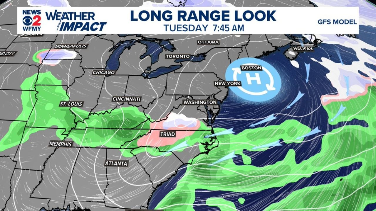
What the Long-Range Pattern Suggests
Model guidance shows high pressure positioned to the northeast while moisture lingers across parts of the Southeast. This type of pattern can support:
• Cold air trapped near the surface
• Persistent cloud cover
• Light overrunning precipitation
If those elements align Monday night, that would create the small icing potential currently being watched.
What This Means for Cabarrus County
For Cabarrus County, the most probable outcome remains straightforward:
• Warm Sunday in the 70s
• Turning sharply colder Monday
• Cloudy, chilly conditions with occasional light rain
The icy mix scenario Monday night is a lower-probability outcome, but even a light glaze can create slick spots on untreated bridges and elevated surfaces.
We’ll continue monitoring updated model trends closely. If temperatures trend colder or moisture lingers longer Monday night, impacts could increase slightly.
If you notice rapidly falling temperatures or slick spots early next week, share your observations with us at CabarrusWeekly.com. We’ll keep tracking this evolving early-week pattern and provide updates as confidence improves.