Colorado Thunderstorms Erupt Along I-25 Corridor and Raton Mesa as Storm Activity Builds Through Friday Morning Near Denver and Trinidad
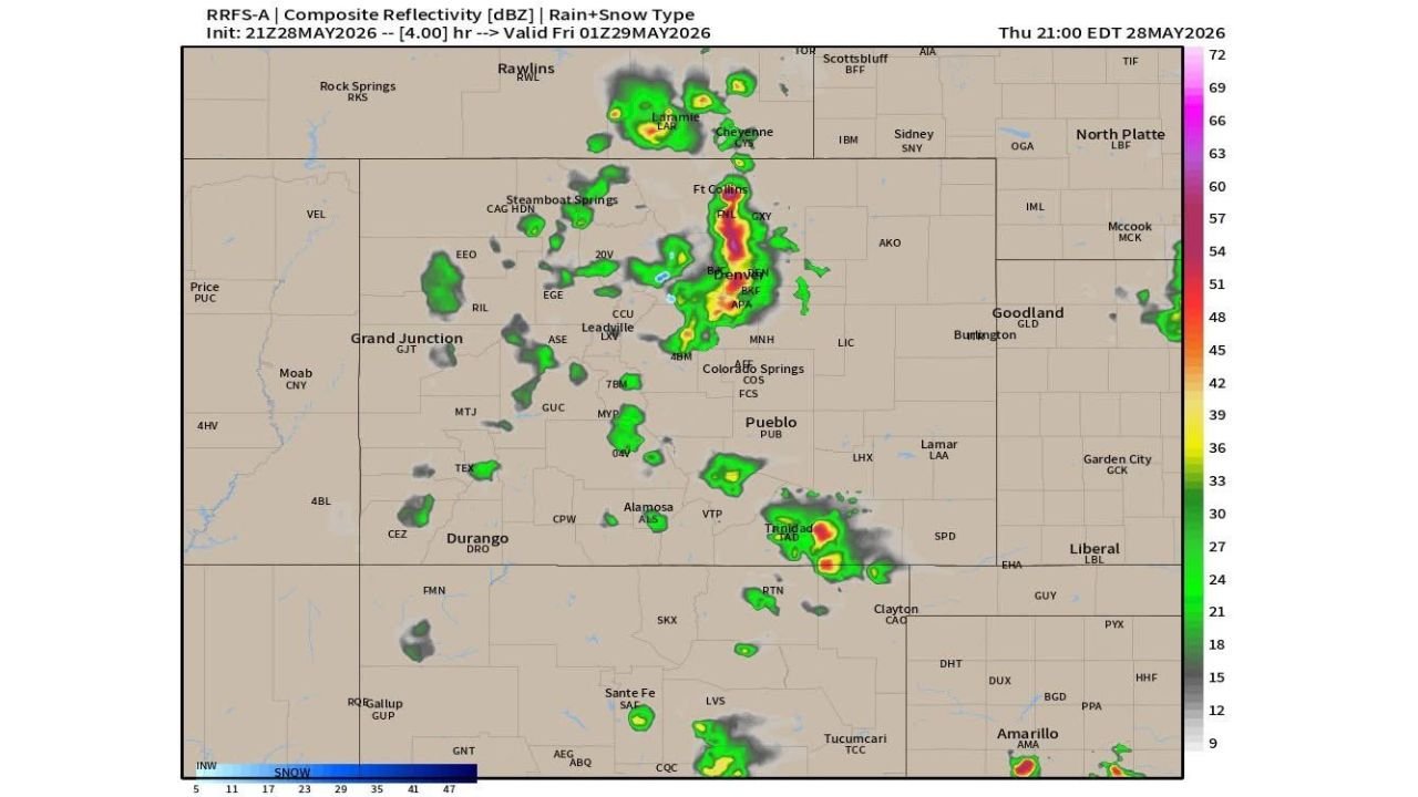
COLORADO — Thunderstorm activity is increasing rapidly across the Colorado Front Range and foothills as of Thursday, May 28, 2026, with storms already firing on the Raton Mesa near Trinidad and additional development expected to surge northward along the I-25 corridor through Friday morning, May 29. The radar forecast, valid at 1:00 AM EDT on Friday, May 29, shows an expanding and intensifying storm complex stretching from Trinidad to Denver and Fort Collins.
Where Storms Are Already Firing
The composite reflectivity map shows active storm cells already producing strong radar returns across several areas:
- Trinidad and the Raton Mesa showing the most intense returns with deep reds and yellows on the reflectivity scale
- Denver metro area including Broomfield and Aurora with a significant storm cluster
- Fort Collins corridor showing active convection
- Laramie, Wyoming with cells pressing northward from the Colorado border
The Trinidad cluster is particularly notable, with reflectivity values reaching into the high dBZ range, indicating heavy rain and potential hail.
The I-25 Corridor and Palmer Divide in Focus
Forecasters are specifically watching the foothills and I-25 corridor for increasing storm development over the next several hours. The Palmer Divide, a geographic feature north of Colorado Springs that acts as a natural trigger for storm initiation, is highlighted as a primary focus area. Upslope flow from the east is enhancing moisture and lift along this corridor, providing the fuel needed for storms to develop and intensify.
Communities along I-25 from Pueblo northward through Colorado Springs, Denver and Fort Collins should anticipate increasing thunderstorm activity through the overnight and early Friday morning hours.
What Outdoor Plans Need to Account For
Anyone with outdoor plans Friday evening across the Colorado Front Range should have a solid weather plan in place. Key considerations:
- Storms can develop quickly along the foothills with limited warning time
- Heavy rain and gusty winds are the primary threats with these storms
- The Denver metro, Fort Collins and Trinidad areas carry the highest immediate risk based on current radar trends
- Move indoors at the first sign of lightning or rapidly darkening skies
Stay with CabarrusWeekly.com for continuing updates as storm activity develops along the Colorado Front Range through Friday.