Oklahoma and Kansas Watch for Isolated Funnel Clouds and Brief Landspout Tornado Risk Friday Afternoon Between 3 and 7 PM
CENTRAL OKLAHOMA — Isolated funnel clouds are possible across central and northwestern Oklahoma and adjacent southwestern Kansas this Friday, May 29, with a low but non-zero chance that one briefly touches down as a landspout tornado. The window for activity runs from 3:00 PM to 7:00 PM Friday afternoon.
Why Funnel Clouds Are Possible Today
This is not a classic supercell setup. Forecasters confirm there is insufficient jet stream energy overhead for rotating supercells to develop. Instead, storms today will be mostly pulse-type thunderstorms, run-of-the-mill in nature.
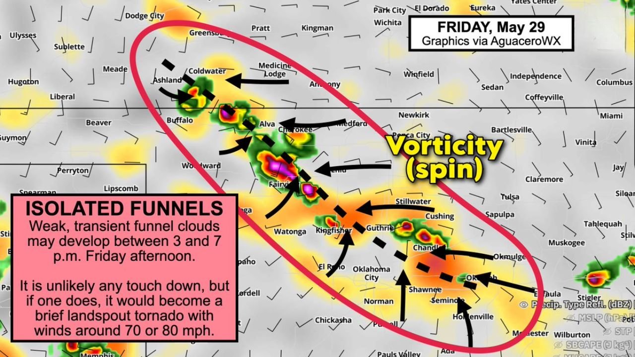
The funnel cloud risk stems from a specific mechanism: surface convergence along a subtle wind-shift line is expected to generate small rotating eddies. When pulse thunderstorms develop over these eddies, the updrafts can vertically stretch the spin, producing an isolated funnel cloud. This process is known as a landspout, and it requires no supercell or mesocyclone to occur.
If a Landspout Touches Down
The image data is specific about what to expect if a landspout does reach the ground:
- Winds would be on the order of 70 to 80 mph, placing it in the EF0 category
- It would be brief and transient in nature
- It would not be associated with a rotating supercell storm
While EF0 tornadoes are on the lower end of the scale, 70 to 80 mph winds are still capable of causing damage to structures, vehicles and trees.
The Primary Risk Zone
The forecast graphic for Friday, May 29 highlights a large oval-shaped risk zone covering:
- Northwestern Oklahoma including Woodward, Alva, Buffalo and Cherokee
- Central Oklahoma including Oklahoma City, El Reno, Kingfisher and Guthrie
- Southwestern Kansas including Coldwater, Ashland, Meade and Liberal
The vorticity zone shown on the map, with converging wind arrows, is concentrated across the Woodward to Oklahoma City corridor, where pulse thunderstorms are most likely to interact with the wind-shift line.
What Oklahoma and Kansas Residents Should Do
- Be weather-aware between 3:00 PM and 7:00 PM Friday afternoon
- Have a weather alert method active and within reach
- If a tornado warning is issued, take shelter immediately regardless of the expected brief and weak nature of any landspout
- Do not attempt to observe funnel clouds from exposed locations
Stay with CabarrusWeekly.com for continuing updates as Friday afternoon storms develop across Oklahoma and Kansas.