Utah Mountains Poised for Heavy Snow as Salt Lake City, Tooele and Provo Face Tricky Thursday–Friday Winter Setup
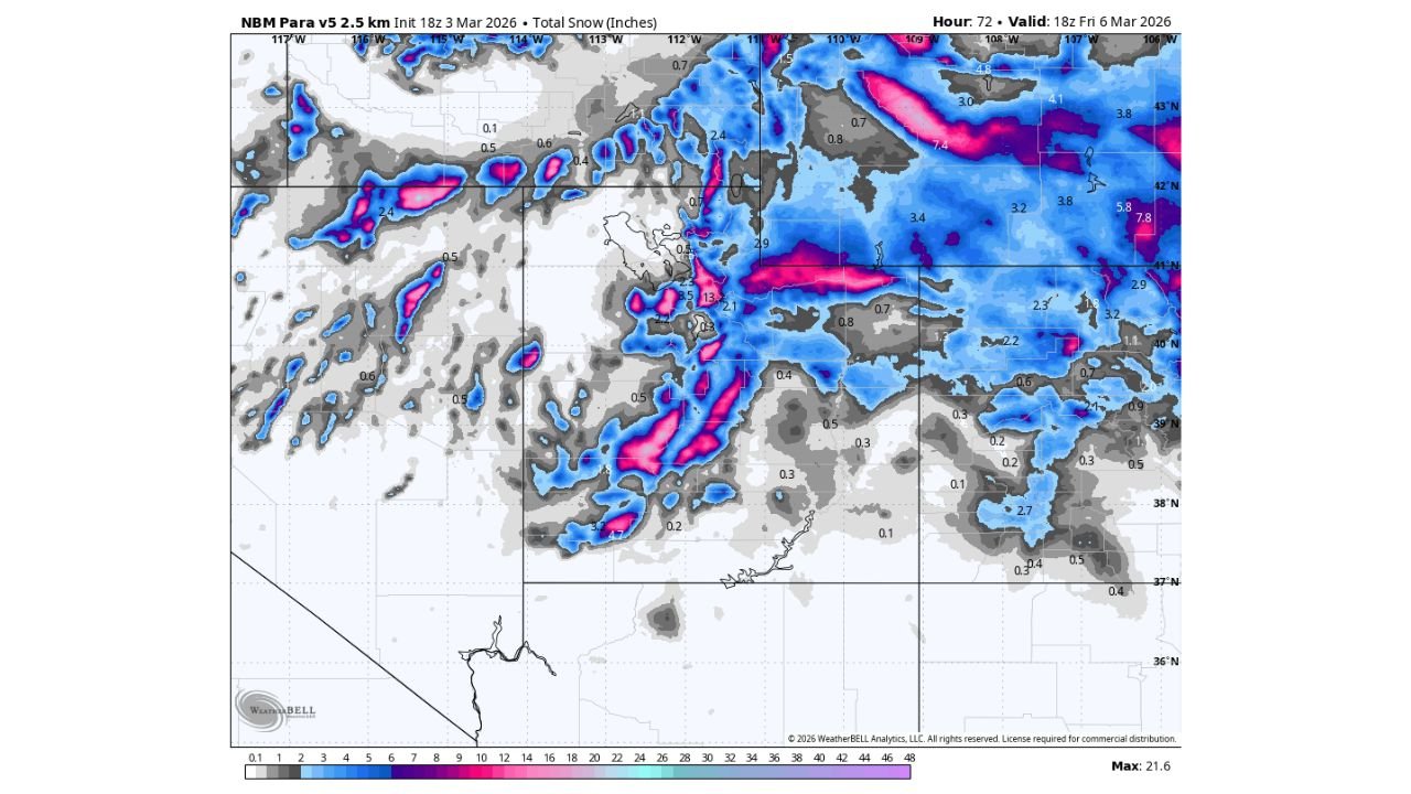
UTAH — A colder storm system is lining up to move into the state Thursday and linger into Friday, with forecast guidance pointing to a solid round of mountain snow and more uncertain totals for the valleys, including Salt Lake City, Provo and Tooele.
While the exact storm track and intensity are still being refined, confidence is growing that Utah’s higher elevations will see the most consistent snowfall.
Mountains Likely the Big Winners
Model projections show widespread snow across the Wasatch and surrounding ranges, with the heaviest bands targeting higher elevations north and east of:
- Salt Lake City
- Ogden
- Provo
- The mountain corridors near Tooele
Snow totals in favored mountain zones could climb into several inches, with localized heavier pockets where terrain enhancement maximizes lift.
Travel across mountain passes may begin deteriorating early Thursday morning and remain difficult into Friday as colder air deepens behind the front.
Valleys Face a Temperature Battle
For lower elevations, including the Salt Lake Valley and Utah Valley, this storm is more dependent on temperature timing.
It appears cold enough for at least some snow in most valley locations, but:
- Totals will depend on how quickly colder air filters in
- A faster cold surge could increase accumulation
- A slower changeover could limit totals
There is also potential for a brief burst of heavier, wetter snow immediately behind the cold front Thursday morning, which could cause commute disruptions if snowfall rates briefly intensify.
Possible Lake-Effect Component Near Tooele
Another wrinkle in the forecast is the possibility of light lake-effect snow Thursday night into early Friday.
While still uncertain and highly localized, guidance suggests the Tooele area could have one of the better chances at enhanced snowfall if wind direction aligns favorably over the Great Salt Lake.
Lake-effect snow is notoriously hit-or-miss and can vary sharply by neighborhood, so pinpointing exact totals this far out remains difficult.
Snowfall Distribution
Forecast maps indicate:
- Stronger, more organized snowfall bands across northern Utah mountains
- Moderate accumulation zones extending east of Salt Lake City
- Lighter, more scattered amounts in southern and lower valley areas
The heaviest swaths appear concentrated along elevated terrain, reinforcing the idea that elevation will be the biggest driver of impact.
Bottom Line
The upcoming Thursday–Friday storm favors Utah’s mountains for the most reliable snowfall, while valley accumulations remain conditional on temperature trends and frontal timing.
Travel through higher elevations could become hazardous early Thursday and remain challenging into Friday. Valley commuters should monitor updates closely, especially Thursday morning when a quick burst of heavy, wet snow is possible.
CabarrusWeekly.com will continue tracking significant national weather systems and provide updates as this winter setup evolves.