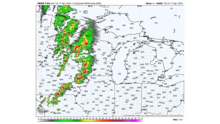
Texas, Arkansas, Oklahoma and Louisiana Face Multiple Rounds of Severe Storms Tuesday With Giant Hail Up to 4 Inches and Tornadoes Possible
SOUTHERN PLAINS AND MID SOUTH — Multiple rounds of severe thunderstorms will impact the southern Plains, lower Mississippi Valley, Tennessee Valley, and Southeast through Tuesday evening, April 28, 2026, with very large to giant hail between 2 and 4-plus inches, swaths of damaging winds, and a few tornadoes all possible across a broad and heavily populated corridor.
Enhanced Risk Covers the Core Zone
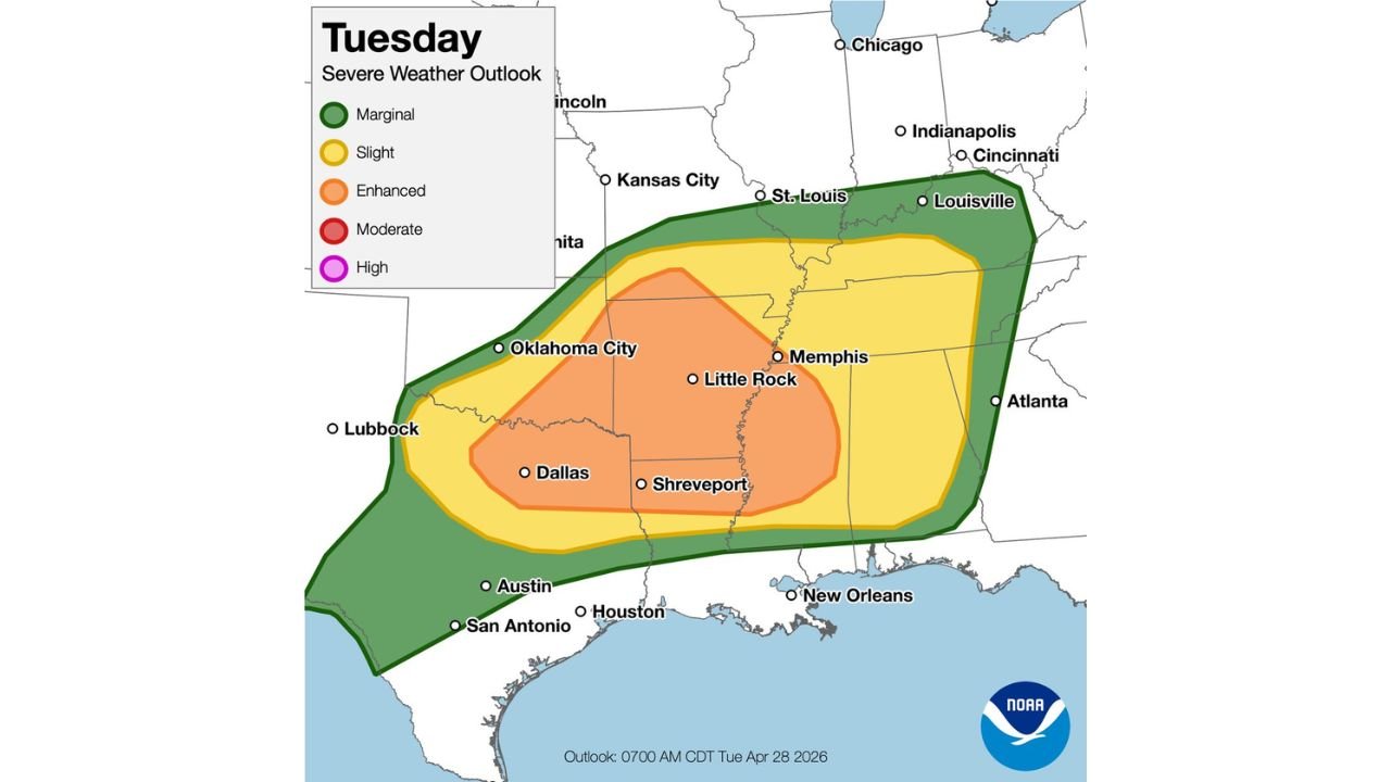
The SPC Tuesday severe weather outlook issued at 7:00 AM CDT places an Enhanced Risk (Level 3 of 5) across the highest-risk corridor stretching from Oklahoma City and Dallas through Shreveport, Little Rock, and Memphis. This zone faces the greatest concentration of all three primary severe weather hazards through the day and evening.
Risk Zone Breakdown
| Risk Level | Key Cities |
|---|---|
| Enhanced Risk — Level 3 | Oklahoma City, Dallas, Shreveport, Little Rock, Memphis |
| Slight Risk — Level 2 | Kansas City, St. Louis, Austin, Houston, New Orleans, Louisville, Atlanta fringe |
| Marginal Risk — Level 1 | Chicago fringe, Indianapolis, Cincinnati, broader Southeast |
Primary Hazards Tuesday
- Very large to giant hail — 2 to 4-plus inches possible with the most intense supercells
- Damaging winds — swaths of severe wind gusts expected across the Enhanced and Slight Risk zones
- A few tornadoes — possible across the core Enhanced Risk corridor
Multiple Rounds Through the Evening
This is not a single isolated storm event. Multiple rounds of severe thunderstorms are expected to impact the region through Tuesday evening, meaning the threat will be ongoing and could affect some areas more than once as successive storm clusters push through.
Residents across Texas, Oklahoma, Arkansas, Louisiana, and Mississippi should remain weather aware through the entire day and evening, keep vehicles protected from large hail, and have shelter plans ready before storms arrive.
Stay with CabarrusWeekly.com for continuing coverage of Tuesday’s severe weather threat across the southern Plains and Mid South.