Increasing Severe Storm Risk Targets Southeast Nebraska and Southwest Iowa Thursday Night Into Friday With Large Hail, Damaging Winds and Tornado Potential
NEBRASKA & IOWA — Confidence is growing in a late-week severe weather setup across southeast Nebraska and southwest Iowa, with thunderstorms possible late Thursday night and a more organized severe threat developing Friday afternoon and evening.
Forecast guidance from the National Weather Service highlights a multi-day window of concern as spring storm season begins to ramp up.
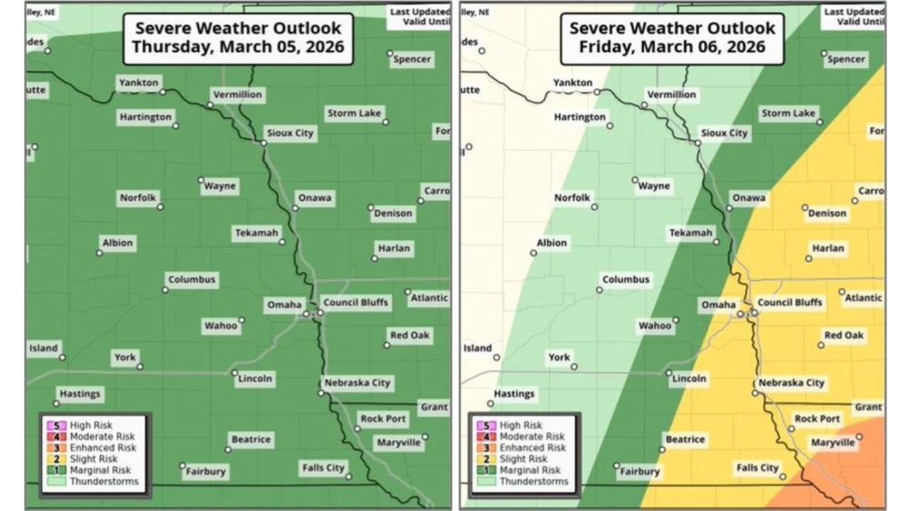
Thursday Night: Initial Severe Risk
Late Thursday night, a low-end severe threat develops across much of eastern Nebraska and western Iowa, including:
- Omaha
- Lincoln
- Nebraska City
- Council Bluffs
- Surrounding communities in southeast Nebraska and southwest Iowa
Storm chances are categorized in the 5–15% range, meaning isolated severe thunderstorms are possible.
The primary concern Thursday night is large hail, though storm coverage is expected to be scattered.
Friday: Stronger Storm Potential Increases
By Friday afternoon and evening, the severe threat becomes more organized across:
- Southeast Nebraska
- Southwest Iowa
- The Omaha metro
- Areas along and east of the Missouri River
The outlook indicates a 15–30% probability of severe thunderstorms, suggesting a higher likelihood of storms capable of producing severe impacts.
Unlike Thursday night, all hazards are possible Friday, including:
- Large hail
- Damaging winds
- Isolated tornadoes
The most favored corridor for stronger storms appears across eastern portions of southeast Nebraska into southwest Iowa.
What to Watch
The late-week timing is especially important, with:
- Storms potentially arriving Thursday night after dark
- Additional development possible Friday afternoon
- Stronger storms continuing into Friday evening
Residents with outdoor plans Friday should stay alert to forecast updates, as conditions may change through the day.
Early Spring Reminder
With March underway, this setup serves as an early reminder that severe weather season is returning to the Central Plains.
While exact storm intensity and coverage will depend on evolving atmospheric details, confidence continues to increase that at least some severe thunderstorms will develop in the region late this week.
CabarrusWeekly.com will continue tracking this developing storm threat and provide updates as newer forecast data becomes available.