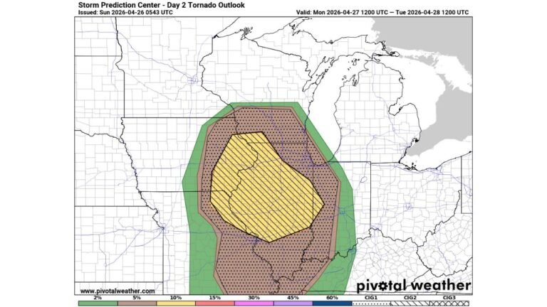
Major Severe Weather Outbreak Underway from Texas to Iowa as Supercells Target Kansas, Missouri and Oklahoma
UNITED STATES — The much-anticipated severe weather day has arrived across the central United States, with a broad and dangerous setup stretching from north Texas through Oklahoma, Kansas, Missouri, and into Iowa and the Upper Midwest.
Forecasters are warning that all hazards are possible today — including strong tornadoes, very large hail, and widespread damaging winds — as atmospheric ingredients align across a large portion of the Plains and Midwest.
Core Risk: Texas to Iowa
The Day 1 Severe Weather Outlook highlights an enhanced corridor from:
- Dallas and Wichita Falls, Texas
- Oklahoma City and Tulsa, Oklahoma
- Wichita and Topeka, Kansas
- Kansas City, Missouri
- Des Moines, Iowa
- Extending northeast toward Milwaukee and parts of southern Wisconsin
This expansive zone reflects a powerful storm system interacting with rich moisture and strong wind shear.
Southern Kansas Dryline in Focus
Storm development is expected along a dryline positioned across southern Kansas into northern Oklahoma and north Texas.
Despite some early model uncertainty about storm coverage, parameters strongly support supercell development if storms initiate. Atmospheric analysis shows:
- Strong instability across southern Kansas and northern Oklahoma
- Significant low-level and deep-layer wind shear
- A supportive environment for rotating storms
Areas near Wichita, Hutchinson, and north toward Kansas City are particularly vulnerable during the afternoon.
Northern Sector: Storms Turn Linear
Farther north into:
- Northeast Kansas
- Southeast Nebraska
- Northwest Missouri
- Iowa
Storms are expected to develop by mid-afternoon.
If sufficient clearing occurs, all hazards remain possible early. However, storms in this region are likely to grow upscale quickly, forming organized lines capable of:
- Widespread damaging wind gusts
- Embedded tornadoes
- Large hail
A strengthening low-level jet later today may enhance wind potential across Kansas City, Des Moines, Omaha, and surrounding communities, especially after sunset.
Timing and Overnight Concerns
This event is expected to evolve in phases:
- Afternoon: Discrete supercells near the dryline in Kansas and Oklahoma
- Evening: Intensification and northeast movement toward Missouri and Iowa
- Overnight: Expanding line segments capable of damaging winds across the Midwest
Nighttime severe weather significantly increases risk due to reduced visibility and sleeping populations.
Safety Reminder
Residents within the risk areas should:
- Have multiple ways to receive warnings
- Enable emergency alerts on mobile devices
- Identify safe shelter locations in advance
- Be prepared to act immediately when warnings are issued
While North Carolina is not in today’s severe zone, this outbreak highlights the volatile spring pattern currently active across the central U.S.
CabarrusWeekly.com will continue monitoring developments as storms intensify and move northeast across the Plains and Midwest.