Illinois Faces High-End Severe Weather Emergency Monday April 27 as SPC Issues CIG2 Signal for Violent EF3 Tornadoes
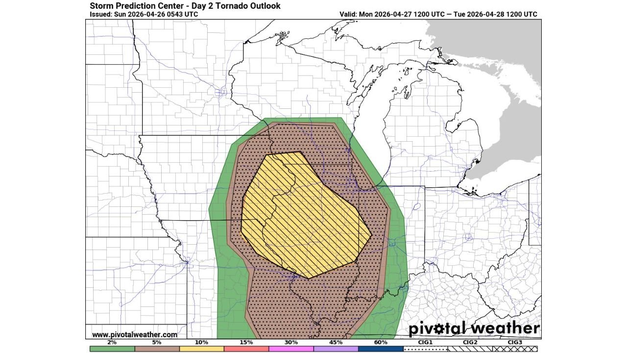
ILLINOIS — The Storm Prediction Center has issued a CIG2 signal — one of the most serious designations in severe weather forecasting — highlighting a serious EF3-or-stronger tornado potential across central to northern Illinois on Monday, April 27, 2026. This is a high-end, life-threatening severe weather threat that every Illinois resident must take seriously today.
What the CIG2 Signal Means
The SPC’s Convective Outlook Intensity Guidance level 2 designation is reserved for setups where violent, long-track tornadoes are considered a serious possibility — not merely an outside chance. It reflects forecaster confidence that the atmospheric environment is primed for the most dangerous storm scenarios. The tornado outlook shows 15 percent or greater tornado probability with CIG2 hatching across central Illinois, with a broader 10 percent or greater zone with CIG1 hatching covering most of the state.
The Atmospheric Setup Is Exceptionally Dangerous
Four ingredients are combining to create a volatile and explosive environment across Illinois on Monday:
Rich Gulf moisture is streaming northward with dewpoints in the 60s°F — the kind of tropical-level humidity that fuels explosive thunderstorm development.
CAPE values of 2,000 to 3,000-plus J/kg will be available to power updrafts of extreme intensity, capable of sustaining large and violent tornadoes.
Deep-layer wind shear of 50 to 70 knots is in place to organize storms into supercells. Even if storm mode becomes somewhat clustered or messy, this level of shear means embedded tornadoes and discrete cells can still produce significant damage.
Strong low-level shear and a powerful low-level jet create a tornado-friendly environment with favorable helicity for tornadogenesis throughout the afternoon and evening hours.
Full Hazard Summary for Monday
- Strong to violent tornadoes — EF3-or-stronger explicitly possible, including long-track events
- Very large hail — up to baseball size, 2.75 inches or larger
- Damaging winds — could exceed 75 mph with any organized storm
- QLCS and embedded tornado threat — continues overnight even if storm mode becomes less discrete
Tornado Probability Breakdown
| Probability Zone | Designation | Coverage |
|---|---|---|
| 15% or greater — hatched | CIG2 | Central Illinois core zone |
| 10% or greater — hatched | CIG1 | Broader Illinois including northern and southern zones |
| 5% or greater | Outer zone | Iowa border, Indiana border, Wisconsin fringe |
Key Concern — Storm Mode
Even if storms do not stay perfectly isolated and discrete, forecasters are clear that the environment is so primed that embedded tornadoes within a storm cluster or QLCS can still cause catastrophic damage. This is not a setup where a messy storm mode eliminates the threat — it simply changes its character.
This Is a Day to Take Seriously
The SPC, NWS, and multiple forecasters are aligned on one message for Monday across Illinois: take this day seriously. Anyone with outdoor plans Monday afternoon or evening should cancel them. Anyone in a mobile home or weak structure must arrange alternative shelter before storms arrive.
- Storms arrive across western Illinois as early as 2:00 PM
- Central and northeast Illinois from 3:00 PM to midnight
- Northwest Indiana from 5:00 PM through 2:00 AM Tuesday
- Have shelter identified and be inside before your area’s window begins
Stay with CabarrusWeekly.com for live and continuous updates throughout Monday as this high-end severe weather event strikes Illinois.