Illinois and Indiana Brace for Widespread Significant Severe Weather Monday April 27 With Strong Tornadoes, Large Hail and Damaging Winds
ILLINOIS AND INDIANA — Widespread significant severe weather is likely across almost all of Illinois and into northwest Indiana on Monday, April 27, 2026, with the NWS maintaining an Enhanced Risk (Level 3 of 5) for the afternoon into overnight hours. Strong tornadoes, large hail, and damaging wind gusts are all possible across a broad and densely populated corridor.
Precise Timing by Region
Storms will develop and move through in a clearly defined sequence:
| Region | Storm Timing |
|---|---|
| Iowa into northwest and western Illinois | 2:00 PM to 9:00 PM |
| North-central, central, and northeast Illinois | 3:00 PM to midnight |
| Northwest Indiana | 5:00 PM to 2:00 AM Tuesday |
Storms will develop across Iowa and Missouri during the early to mid afternoon, push into western Illinois by late afternoon and early evening, sweep across Illinois through Monday evening, and then continue east into Indiana overnight into Tuesday morning.
How the Day Will Unfold
Morning and afternoon showers are possible across northern Illinois ahead of the main event. These should clear out and allow the atmosphere time to destabilize before the main storm line arrives. If morning rain exits early enough, all hazards will be likely across the full risk zone.
The key variable is whether lingering morning rain across northern Illinois holds back instability — if so, the highest severe weather risks may shift south across central and southern Illinois.
Enhanced Risk Covers Almost All of Illinois
The Enhanced Risk zone on the NWS outlook covers the vast majority of Illinois, including:
Rockford, DeKalb, Aurora, Moline, Galesburg, Peoria, Bloomington, Quincy, Springfield, Champaign, Effingham, East St. Louis, Mt. Vernon, Carbondale, and Marion.
A surrounding Slight Risk extends into the Chicago metro, Kankakee, and into Indiana.
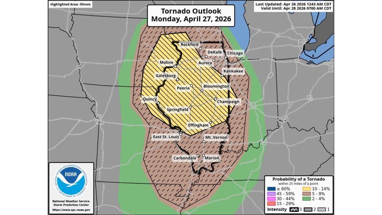
Tornado Probability Outlook
The tornado probability map shows significant hatching across nearly the entire state:
| Tornado Probability | Areas |
|---|---|
| 15 to 29% — hatched (significant tornadoes) | Broad zone covering most of Illinois including Carbondale, Marion, Mt. Vernon, East St. Louis |
| 10 to 14% — hatched (significant tornadoes) | Central corridor — Peoria, Bloomington, Springfield, Effingham, Quincy, Moline, Rockford, Aurora |
| 5 to 9% | Outer fringe including Chicago and Kankakee |
The intensity 2 and intensity 3 hatching across the tornado outlook confirms that significant tornadoes — EF2 or stronger — are explicitly anticipated within the highest probability zones.
Full Hazard List for Monday
- Strong tornadoes — several possible, EF2 or stronger explicitly indicated
- Large hail — significant threat across the Enhanced Risk zone
- Damaging wind gusts — widespread with any organized storm line
- Overnight QLCS tornado threat — continuing into northwest Indiana into Tuesday morning
Act Before Monday Afternoon
Anyone across Illinois and northwest Indiana must be prepared before storms arrive. Do not wait for warnings to be issued.
- Identify your shelter on the lowest floor of a sturdy permanent building
- Have multiple ways to receive tornado warnings active — including overnight
- Avoid outdoor plans Monday afternoon and evening entirely
- Mobile homes offer zero protection — arrange alternative shelter now
Stay with CabarrusWeekly.com for continuing updates throughout Monday as this significant severe weather event unfolds across Illinois and Indiana.