Omega Block Developing Late This Week Over the United States Cutting Severe Weather Chances Through Early June
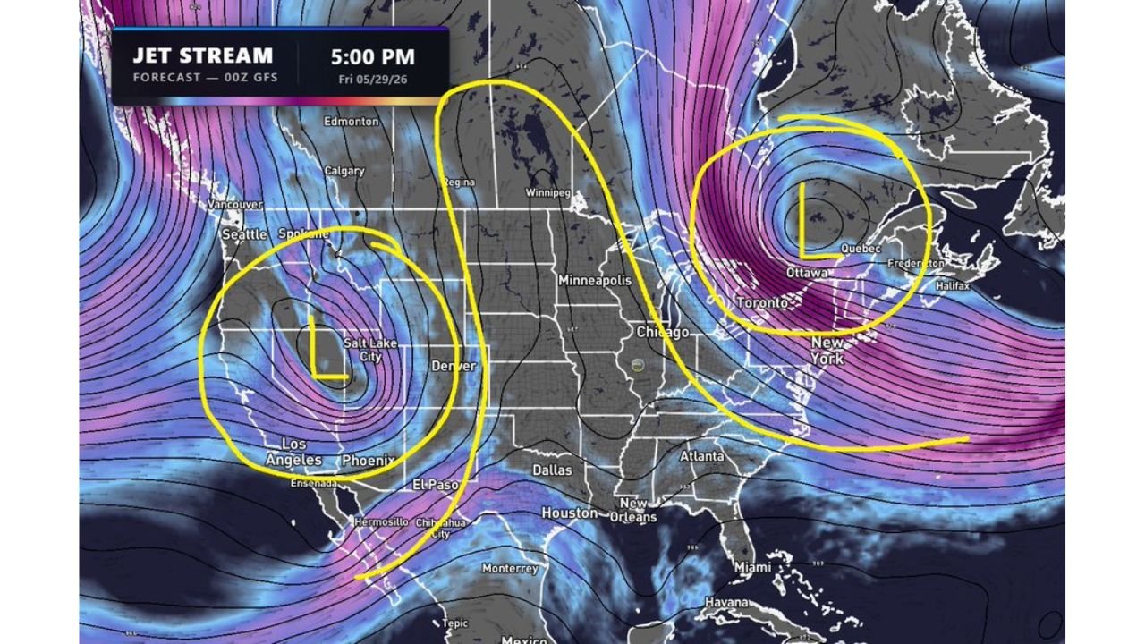
UNITED STATES — An Omega Block weather pattern is developing late this week, with the GFS jet stream forecast valid at 5:00 PM Friday May 29, 2026 showing two large low pressure systems locking into position on either side of a central high pressure dome. This pattern is expected to decrease chances of severe weather outbreaks across the country for the foreseeable future as the block establishes and holds through the start of June.
What the Jet Stream Map Shows
The 00z GFS jet stream forecast valid for Friday May 29, 2026 at 5:00 PM clearly shows the omega block structure taking shape across the North American continent.
Jet stream pattern breakdown:
| Feature | Position | Areas Affected |
|---|---|---|
| Low pressure (L) Western | Pacific Coast / Great Basin | Seattle, Salt Lake City, Los Angeles, Phoenix corridor |
| High pressure ridge (H) | Central Canada / Northern Plains | Regina, Winnipeg, Edmonton corridor |
| Low pressure (L) Eastern | Eastern Canada / Northeast | Ottawa, Quebec, Fredericton, Halifax corridor |
| Jet stream flow | Deflected north into Canada | Bypassing the central United States entirely |
| Southern jet branch | Curving through Gulf Coast | Houston, New Orleans, Miami corridor |
The two yellow circles drawn on the map highlight the western low near Salt Lake City and the eastern low near Ottawa and Quebec, with the high pressure ridge sandwiched between them across central Canada.
How the Omega Block Works
The omega block gets its name from the shape the jet stream forms when the pattern is fully established, resembling the Greek letter omega.
Mechanics of the omega block:
- Two counterclockwise lows on the western and eastern flanks lock into position
- Clockwise high pressure in the center acts as a wall deflecting storm energy away
- Jet stream buckles northward over the high, pushing storm tracks into Canada
- Storm systems stall rather than progressing normally across the country
- Hot and dry sinking air builds beneath the high pressure center
- The entire configuration locks in place like interlocked gears and resists breaking down for days to weeks
Why Severe Weather Chances Drop Significantly
The omega block directly attacks the atmospheric ingredients needed for severe thunderstorm and tornado development across the United States.
How the block reduces severe weather:
- Jet stream energy deflected into Canada removes the wind shear storms need to organize
- Sinking air beneath the high suppresses storm development across the central U.S.
- Storm tracks rerouted to the far north and far south, bypassing Tornado Alley
- No upper level disturbances can penetrate the central block to trigger severe setups
- Atmospheric instability decreases under the warming and drying influence of the high
Which Regions See the Most Impact
Central United States including the Plains and Midwest: Directly beneath the high pressure ridge, these areas will see the strongest suppression of storm activity. Severe weather chances drop to near zero while the block holds.
Pacific Northwest including Seattle and the Western Low zone: Remains active on the western flank of the block with the low pressure system keeping unsettled conditions in place across Washington, Oregon, and into the Great Basin.
Northeast and Eastern Canada: The eastern low keeps active weather possible across New England and into the Canadian Maritime provinces, but severe weather organization remains limited.
Gulf Coast and Southeast: The southern branch of the jet stream curving through Houston, New Orleans, and toward Miami maintains some storm potential across the Gulf Coast states, though the block limits organization of any significant severe weather outbreaks.
How Long the Block Is Expected to Last
Omega blocks are known for their persistence once established. The pattern is currently expected to develop late this week and hold through the foreseeable future, with forecasters not anticipating a meaningful breakdown before at least early to mid June.
Omega block duration outlook:
| Period | Expected Condition |
|---|---|
| Now through May 28 | Block developing and establishing |
| May 29 through June 5 | Block fully established, severe weather suppressed |
| June 6 and beyond | Possible pattern shift, monitoring required |
| Confidence in duration | Moderate, subject to model updates |
Stay with CabarrusWeekly.com for continuing updates on the omega block pattern and its impact on severe weather chances across the United States through early June.