Dangerous Supercells With Gorilla Hail and Isolated Tornadoes Erupting Off Northern Mexico Mountains Along the Rio Grande as Val Verde County Faces Tail End Supercell Threat
NORTHERN MEXICO AND SOUTHWEST TEXAS — Supercells capable of dropping gorilla hail and producing an isolated tornado are erupting off the mountains of northern Mexico, with the most intense activity concentrated along and just south of the Rio Grande. A tail end supercell is likely in Val Verde County with very large hail as the primary threat, while a large bore or density current is expected to clean out instability across a large part of west Texas ahead of the supercell development zone.
What the Radar Is Showing Right Now
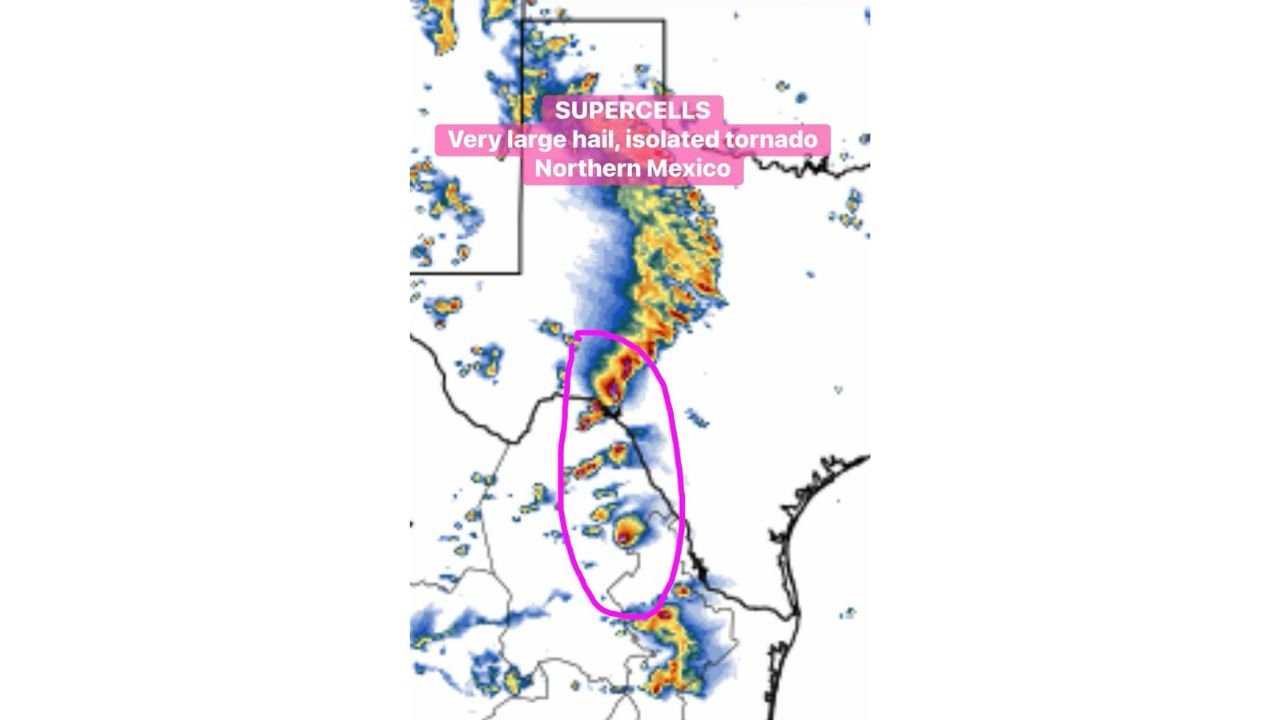
The radar image shows an active and intense storm complex with the supercell threat zone clearly circled in pink along the Rio Grande corridor.
Current radar conditions by area:
| Area | Radar Status |
|---|---|
| Northern Mexico mountains | Intense red and orange returns, supercells erupting |
| Rio Grande corridor | Heavy active returns, pink circle marks supercell zone |
| Val Verde County Texas | Tail end supercell development area |
| West Texas broader area | Active convective line moving through |
| South of the Rio Grande | Additional storm cells developing southward |
The pink circle on the radar is centered directly along the Rio Grande border corridor, highlighting the zone where discrete supercell development is most active and most dangerous right now.
The Two Distinct Threats in This Sector
Threat 1 — Northern Mexico Supercells:
- Supercells erupting off the mountains of northern Mexico along and south of the Rio Grande
- Capable of producing gorilla hail, referring to extremely large and destructive hailstones
- Isolated tornado possible with the most organized supercell storms
- Northern Mexico historically goes big during El Nino springs, making this event consistent with the known climate pattern for the region this time of year
Threat 2 — Val Verde County Tail End Supercell:
- A tail end supercell is likely in Val Verde County on the Texas side of the border
- Very large hail is the primary hazard with this storm
- The tail end position of a supercell is often the most dangerous and discrete storm in a complex
- Large bore or density current will clean out instability across much of west Texas but leaves Val Verde County exposed to this isolated but significant threat
Hazard Summary for the Rio Grande Corridor
Active severe weather hazards along and near the Rio Grande:
| Hazard | Threat Level | Primary Zone |
|---|---|---|
| Gorilla hail | Primary and significant | Northern Mexico supercells |
| Very large hail | Primary threat | Val Verde County, Texas |
| Isolated tornado | Possible | Along and south of Rio Grande |
| Heavy rainfall | Ongoing | Entire storm corridor |
| Dangerous lightning | With all cells | Entire affected area |
Why Northern Mexico Erupts During El Nino Springs
The supercell development firing off the northern Mexico mountains today is not random. Forecasters note that northern Mexico often produces significant severe weather during El Nino spring seasons, as the combination of enhanced Gulf moisture, a more active subtropical jet stream, and elevated terrain provides the lift, instability, and wind shear that supercells require.
The mountain terrain of northern Mexico acts as a forcing mechanism, triggering storm initiation along the elevated terrain before storms intensify as they move off the slopes and into the more unstable air over the lower terrain to the east.
What Residents Near Val Verde County Should Do
With a tail end supercell likely in Val Verde County and the broader supercell complex active along the Rio Grande, residents in the immediate area need to act now.
- Seek sturdy shelter immediately if storms approach your location
- Very large hail can be life-threatening outdoors and will cause significant vehicle and property damage
- Do not shelter under highway overpasses during tornado or severe hail events
- Move vehicles undercover before hail-producing storms arrive if time permits
- Monitor NWS severe thunderstorm and tornado warnings for Val Verde County closely
- Stay away from windows when large hail is falling
Stay with CabarrusWeekly.com for continuing updates on the Val Verde County and Rio Grande severe weather threat through Tuesday afternoon.