Rio Grande Valley, Texas Hill Country, and Permian Basin Face Slight Risk Severe Weather Tuesday With Baseball Hail, 60 MPH Gusts, and Isolated Tornado Possible South of I-10
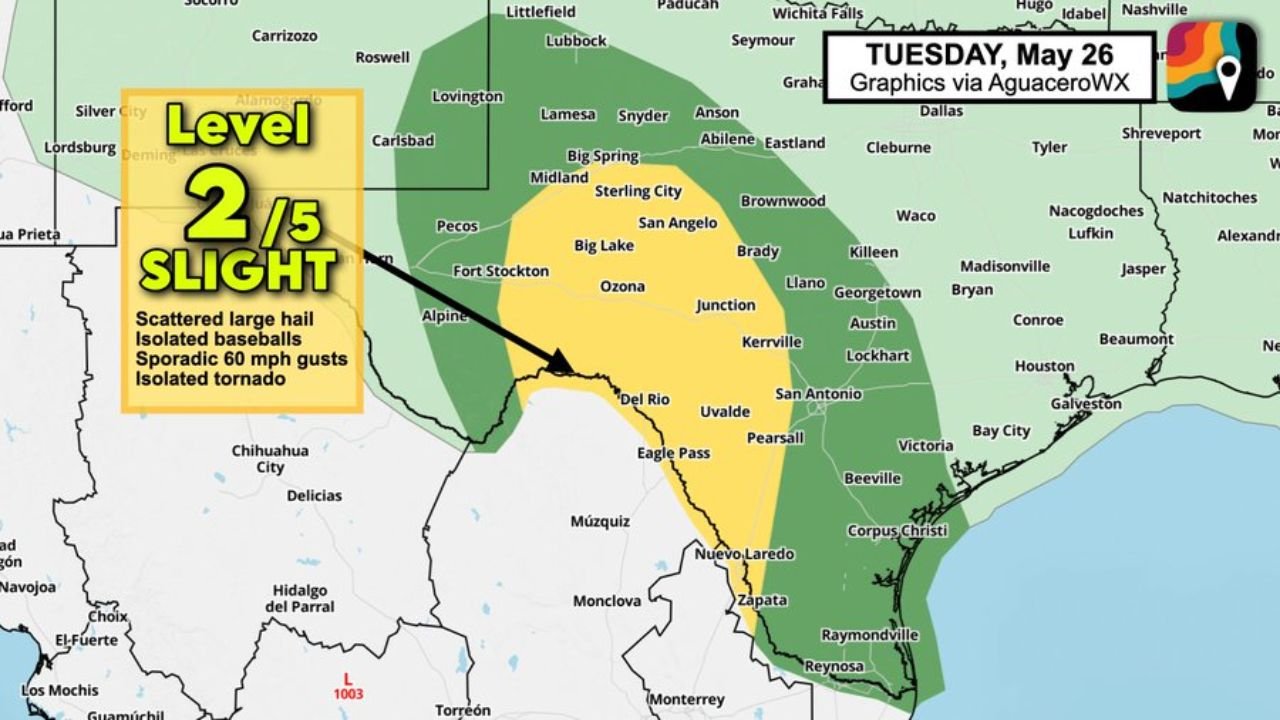
SOUTHWEST AND CENTRAL TEXAS — A Slight Risk level 2 of 5 severe weather threat is in place across the Rio Grande Valley, Texas Hill Country, and the Permian Basin on Tuesday May 26, 2026, with hail-producing supercells possible this afternoon. The threat includes scattered large hail, isolated baseball-sized hail, sporadic 60 MPH wind gusts, and an isolated tornado with the tornado risk focused primarily in the Permian Basin south of I-10.
Full Risk Zone Breakdown for Tuesday May 26
Severe weather risk by area:
| Risk Level | Zone | Key Cities |
|---|---|---|
| Slight Risk (2/5) | West Texas / Permian Basin | Midland, Pecos, Fort Stockton, Big Spring, Sterling City, Ozona |
| Slight Risk (2/5) | Rio Grande Valley / Del Rio corridor | Del Rio, Eagle Pass, Uvalde |
| Marginal Risk (1/5) | Broader West and Central Texas | Lubbock, San Angelo, Junction, Kerrville, San Antonio fringe |
| Marginal Risk (1/5) | South Texas corridor | Corpus Christi, Nuevo Laredo, Laredo area |
| General Thunderstorms | East Texas fringe | Waco, Austin, Tyler, Nacogdoches |
Full Hazard Breakdown
All hazards in play Tuesday across the Slight Risk zone:
| Hazard | Threat Level | Primary Zone |
|---|---|---|
| Scattered large hail | Primary and widespread | Entire Slight Risk zone |
| Isolated baseball-sized hail | Possible with strongest supercells | Permian Basin and Rio Grande corridor |
| Sporadic wind gusts 60 MPH | Possible | Slight Risk zone |
| Isolated tornado | Possible | Permian Basin south of I-10 |
| Heavy rainfall | Secondary | Widespread across risk areas |
| Frequent lightning | With all cells | Entire affected region |
Where the Tornado Risk Is Focused
The isolated tornado threat is not widespread across the entire risk zone. Forecasters are specifically pointing to the Permian Basin south of Interstate 10 as the primary corridor where tornado development is most possible with the most organized supercell storms this afternoon.
Tornado risk zone specifics:
- Primary area: Permian Basin south of I-10
- Cities in this corridor: Pecos, Fort Stockton, Ozona, Big Lake, and surrounding communities
- Mechanism: Discrete supercell development with enough rotation for tornado production
- Confidence: Isolated, not a widespread tornado outbreak scenario
- Timing: This afternoon into the early evening hours
Rio Grande Valley and Texas Hill Country Hail Threat
While the tornado risk is focused on the Permian Basin, the Rio Grande Valley and Texas Hill Country are squarely in the hail threat zone with supercells capable of producing large to very large hail during the afternoon hours.
Hail threat details:
- Scattered large hail is the most likely outcome across the broader Slight Risk zone
- Isolated baseball-sized hail is possible with the strongest and most discrete supercells
- Baseball-sized hail measures approximately 2.75 inches in diameter and is capable of causing significant damage to vehicles, roofs, and property
- Del Rio, Uvalde, Kerrville, Junction, and the Hill Country corridor all sit within range of hail-producing storms this afternoon
What Residents Across the Risk Zone Should Do
With storms expected to develop during the afternoon hours on Tuesday, preparation time is available now for residents across southwest and central Texas.
- Move vehicles undercover before afternoon storm development if possible
- Baseball-sized hail will cause serious vehicle and roof damage with no warning on storm arrival
- Residents in the Permian Basin south of I-10 should have tornado shelter plans ready
- 60 MPH wind gusts can down trees and power lines with little advance notice
- Monitor NWS severe thunderstorm and tornado warnings throughout the afternoon and evening
- Avoid outdoor activities across the Slight Risk zone during peak storm hours this afternoon
Stay with CabarrusWeekly.com for continuing updates on the southwest and central Texas severe weather threat through Tuesday afternoon and evening.