Central and Northeastern Kansas and Southeastern Nebraska Placed Under SPC Moderate Risk as Day 2 Outlook Locks In Monday Severe Weather Threat
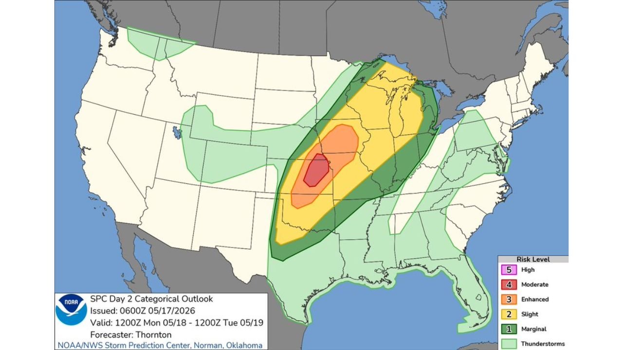
KANSAS AND NEBRASKA — The Storm Prediction Center issued its Day 2 Categorical Outlook at 1:12 AM CDT on Sunday, May 17, 2026, placing portions of central and northeastern Kansas into far southeastern Nebraska under a Moderate Risk of severe weather valid from Monday, May 18 through Tuesday, May 19, 2026. The outlook was issued by SPC forecaster Thornton out of Norman, Oklahoma.
The SPC Has Officially Locked In the Moderate Risk Zone
This is no longer a general threat. The Storm Prediction Center has drawn a defined Moderate Risk zone directly over central and northeastern Kansas and far southeastern Nebraska. This is the bullseye for Monday’s severe weather event, and it represents one of the highest risk designations the SPC issues on its categorical outlook scale.
Every Risk Level and What It Covers
The Day 2 outlook paints a large and layered picture of severe weather risk stretching across a massive portion of the country:
| Risk Level | Coverage |
|---|---|
| Moderate (Level 4) | Central and northeastern Kansas, far southeastern Nebraska |
| Enhanced (Level 3) | Broader zone surrounding the Moderate Risk core |
| Slight (Level 2) | Large area covering much of the Great Plains and Midwest |
| Marginal (Level 1) | Wide surrounding region extending into multiple states |
| Thunderstorms | Broad coverage reaching the Gulf Coast and beyond |
What This Outlook Tells Us About Monday
The Moderate Risk designation from the SPC confirms that widespread severe storms are expected across the core zone. The tight, well-defined nature of the risk area signals that forecasters have high confidence in where the most dangerous storms will develop. The broader Slight and Enhanced zones surrounding it show that the severe weather threat extends well beyond just Kansas and Nebraska.
The Valid Window for This Threat
This outlook covers the period from 1200Z Monday, May 18 through 1200Z Tuesday, May 19, 2026, meaning the threat window spans Monday afternoon through Monday night across the affected region.
Residents Must Be Ready Before Monday Arrives
With the SPC now officially locking in the Moderate Risk zone, anyone living across central and northeastern Kansas and southeastern Nebraska should treat Monday as a serious weather emergency day. Shelters should be identified, alert systems should be active, and plans should be in place before storms develop Monday afternoon.
Stay with CabarrusWeekly.com for full coverage and live updates as Monday’s severe weather outbreak unfolds.