Tuesday’s Severe Weather Corridor Expands: Damaging Winds, Large Hail and Tornado Threat From Texas Through Arkansas, Missouri and Into Illinois
UNITED STATES — Severe weather season is ramping up once again as a renewed threat is expected Tuesday afternoon and evening across a broad corridor stretching from South Texas through Arkansas, Missouri, and into Illinois.
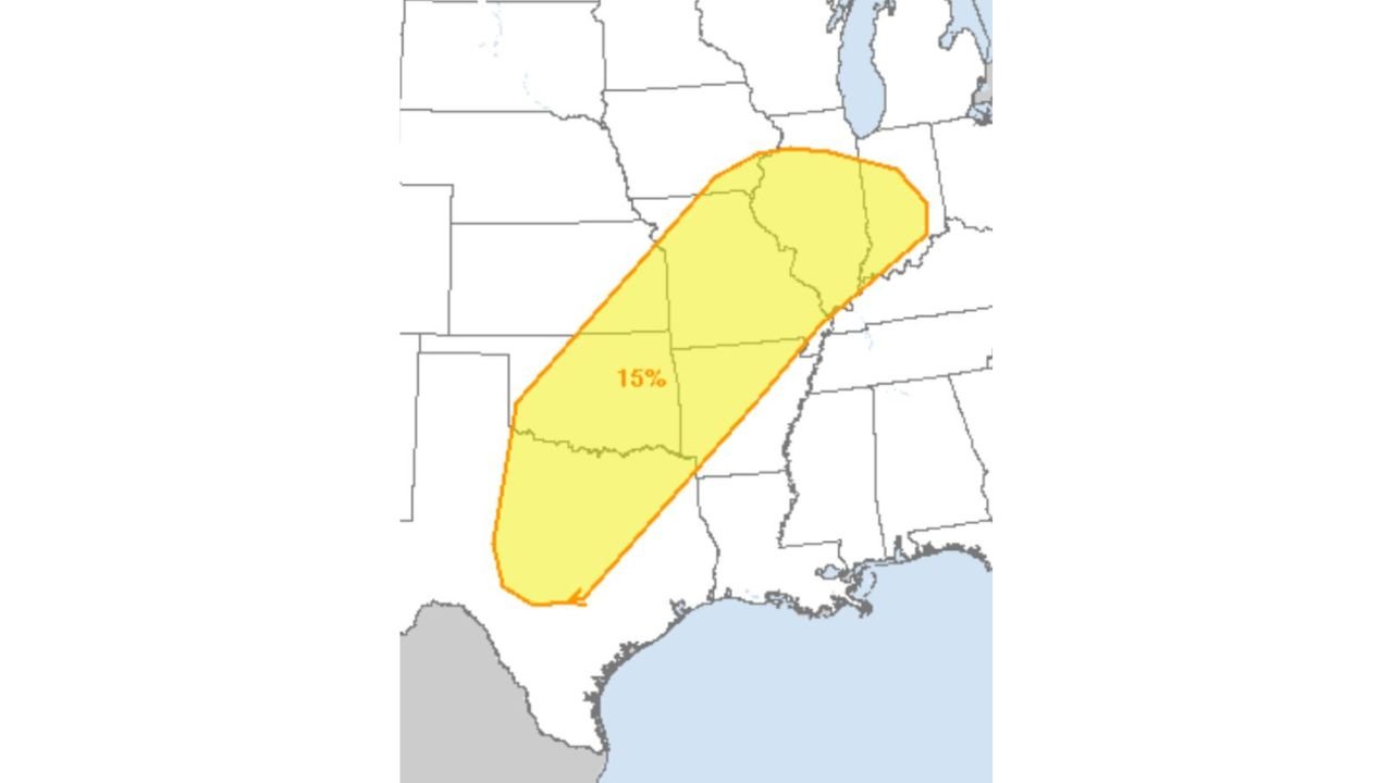
The latest outlook highlights a 15% severe probability zone extending in a southwest-to-northeast arc, signaling a notable setup capable of producing damaging winds, large hail, and tornadoes.
Where the Risk Is Focused
The highlighted corridor begins in:
- South and Southeast Texas
- Extends northward through East Texas
- Spreads across much of Arkansas
- Covers large portions of Missouri
- Reaches into Illinois
This elongated risk zone suggests a classic Plains-to-Midwest severe weather track, often associated with strengthening spring storm systems.
Timing: Afternoon Into Evening
The primary window for storm development will likely occur during the Tuesday afternoon and evening hours, when daytime heating combines with strengthening wind fields aloft.
Storms are expected to organize along an advancing frontal boundary, with conditions supportive of rotating thunderstorms.
Main Hazards
Forecasters indicate that all modes of severe weather are possible within the risk area:
Damaging Winds
Strong wind gusts could accompany organized storm clusters or squall lines, especially as storms mature and move northeast.
Large Hail
Steep instability profiles may allow storms to produce significant hail, particularly in more discrete supercells before storms grow into a line.
Tornado Potential
With sufficient wind shear expected along the corridor, rotating storms could develop, bringing the possibility of tornadoes — especially in areas where storms remain isolated ahead of the main line.
What Makes This Setup Notable
A 15% severe probability covering multiple states is not minor. It reflects a broad environment favorable for organized thunderstorms rather than isolated, weak cells.
The southwest-to-northeast alignment from Texas to Illinois suggests:
- Strong upper-level support
- Robust Gulf moisture return
- Favorable wind shear profiles
These are classic ingredients that signal the beginning stages of an active severe weather stretch.
What Residents Should Do
Communities across Texas, Arkansas, Missouri, and Illinois should:
- Monitor forecast updates through Tuesday
- Ensure weather alerts are enabled
- Review severe weather safety plans
While not every location within the corridor will experience severe storms, the environment will be supportive enough that any storm that forms could intensify quickly.
CabarrusWeekly.com will continue tracking this developing system as Tuesday’s severe weather threat approaches.