Minnesota and Wisconsin Face Morning Frost and Freeze Risk Thursday Through the Weekend With Lows Dropping Into the 20s and 30s
MINNESOTA / WISCONSIN — A cold and dry stretch of weather is settling across Minnesota and Wisconsin over the next couple of days, with morning frost possible and some locations at risk of a hard freeze heading into Thursday morning, April 30, 2026. Temperatures will gradually recover toward near normal by the weekend, with no major rain systems expected over the next week.
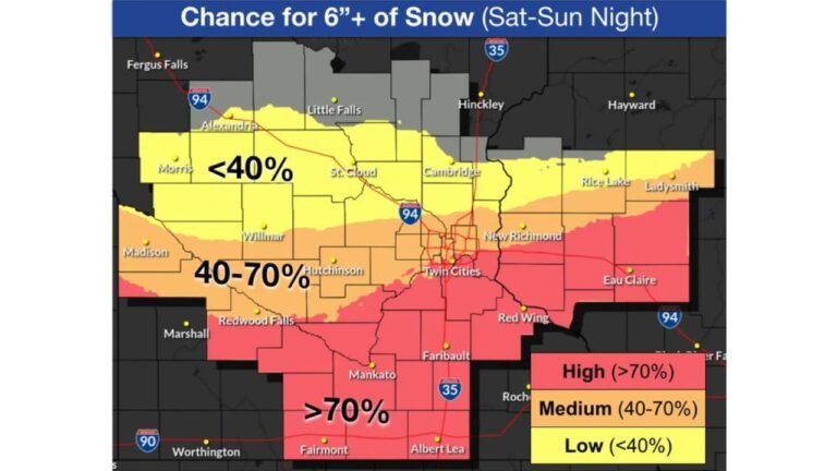
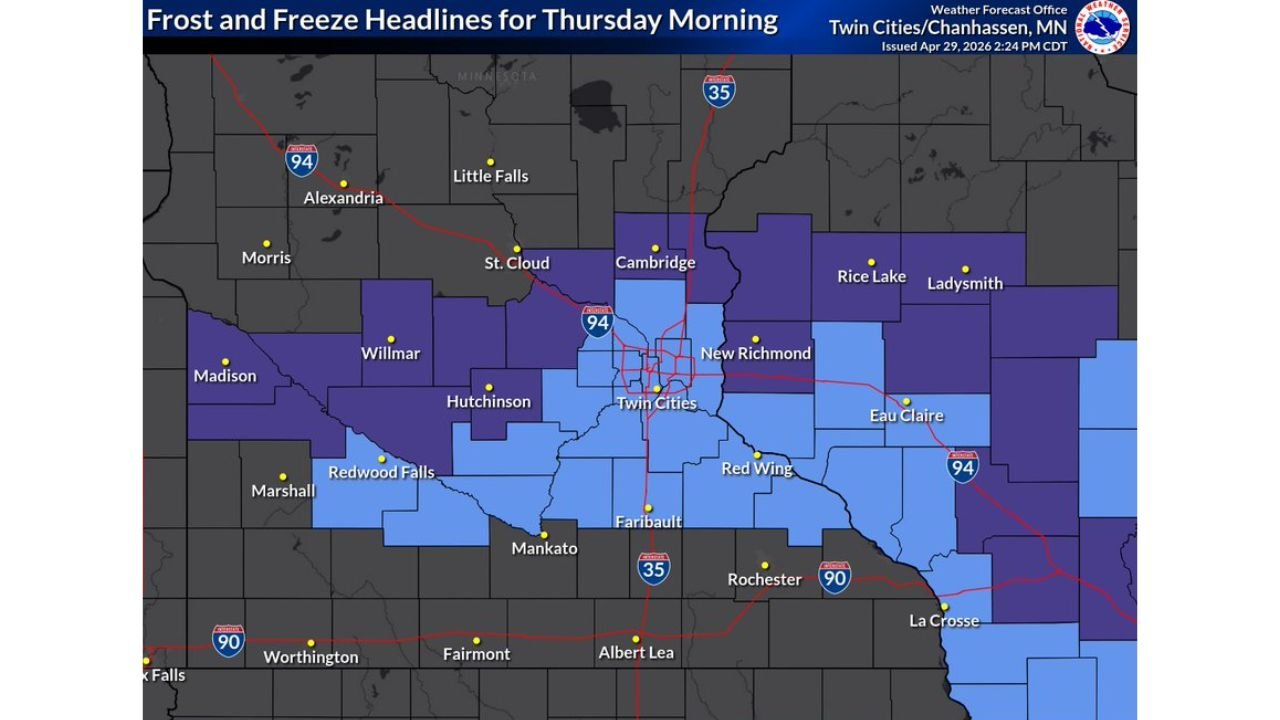
Frost and Freeze Headlines in Place for Thursday Morning
The National Weather Service Twin Cities issued Frost and Freeze Headlines for Thursday morning at 2:24 PM CDT on April 29, 2026. The affected zone covers a wide area across central and southern Minnesota and into western Wisconsin, including:
Freeze Watch / Frost areas include: Twin Cities, St. Cloud, Cambridge, New Richmond, Willmar, Hutchinson, Redwood Falls, Mankato, Faribault, Red Wing, Eau Claire, Rice Lake, Ladysmith, Marshall, Alexandria, Little Falls, and Rochester.
The darker purple shading on the map indicates the areas at greatest risk for a hard freeze, while the lighter blue zones face frost conditions.
How Cold Overnight Lows Will Get
Minimum temperature forecast data issued Wednesday, April 29, 2026 at 2:08 PM shows dangerously cold overnight lows through the first couple days of May:
| City | Thu 4/30 | Fri 5/1 | Sat 5/2 | Sun 5/3 |
|---|---|---|---|---|
| Little Falls | 29° | 29° | 30° | 43° |
| Alexandria | 30° | 30° | 32° | 43° |
| Ladysmith | 31° | 30° | 28° | 39° |
| Saint Cloud | 30° | 31° | 31° | 44° |
| Mora | 30° | 31° | 30° | 42° |
| Willmar | 31° | 31° | 31° | 44° |
| Hutchinson | 32° | 32° | 32° | 45° |
| Madison | 30° | 31° | 31° | 44° |
| Redwood Falls | 32° | 32° | 31° | 44° |
| Eau Claire | 34° | 33° | 30° | 42° |
| Twin Cities | 35° | 36° | 36° | 47° |
| Mankato | 35° | 34° | 33° | 46° |
| Albert Lea | 35° | 32° | 31° | 44° |
| Fairmont | 36° | 33° | 32° | 45° |
Lows drop to as cold as 28 degrees in Ladysmith and 29 degrees in Little Falls during this stretch — well below freezing and capable of damaging newly planted crops and tender vegetation.
The Weekend Recovery and Week Ahead
Temperatures begin recovering toward near normal heading into the weekend, with Sunday lows climbing back into the mid-40s for most locations. The Twin Cities are forecast to reach 47 degrees for a Sunday low. No major rain systems are expected across the region over the next week, keeping conditions dry but gradually moderating through the first week of May.
Gardeners and agricultural producers across Minnesota and Wisconsin should take precautions to protect sensitive plants and newly planted crops through at least Saturday morning as overnight lows remain in frost and freeze territory.
Stay with CabarrusWeekly.com for continuing updates on the frost and freeze risk across Minnesota and Wisconsin.