Oklahoma, Arkansas, Louisiana, Kansas, Missouri and Midwest States Face Three-Day Severe Weather Outbreak With Tornado Outbreak Possible by Monday
CENTRAL AND SOUTHERN UNITED STATES — A significant multi-day severe weather sequence is now underway across the Plains and will intensify through the weekend before reaching its most dangerous and widespread phase on Monday, April 27, 2026, with the potential for a full tornado outbreak across the Mid-South and Midwest.
Saturday April 25 — Enhanced Risk Across Louisiana, Oklahoma and Arkansas
The sequence begins Saturday with an Enhanced Risk (Level 3) centered across Oklahoma, surrounded by a Slight Risk extending into Louisiana, Arkansas, and surrounding states. The SPC Day 2 outlook issued April 24 highlights damaging winds and large hail as the primary threats, with at least a low tornado risk during the afternoon and evening hours.
Supercells are expected to develop east of I-35 during the afternoon and push through eastern Oklahoma and into western Arkansas through the evening.
Sunday April 26 — Substantial Tornado Threat Shifts North Into Kansas and Missouri
Sunday brings a more substantial severe and tornado threat, though the setup has trended slightly more conditional as of the latest guidance. Forcing systems are tracking a bit slower and farther north than earlier forecast, which is shifting the greatest risk zone into Kansas and Missouri.
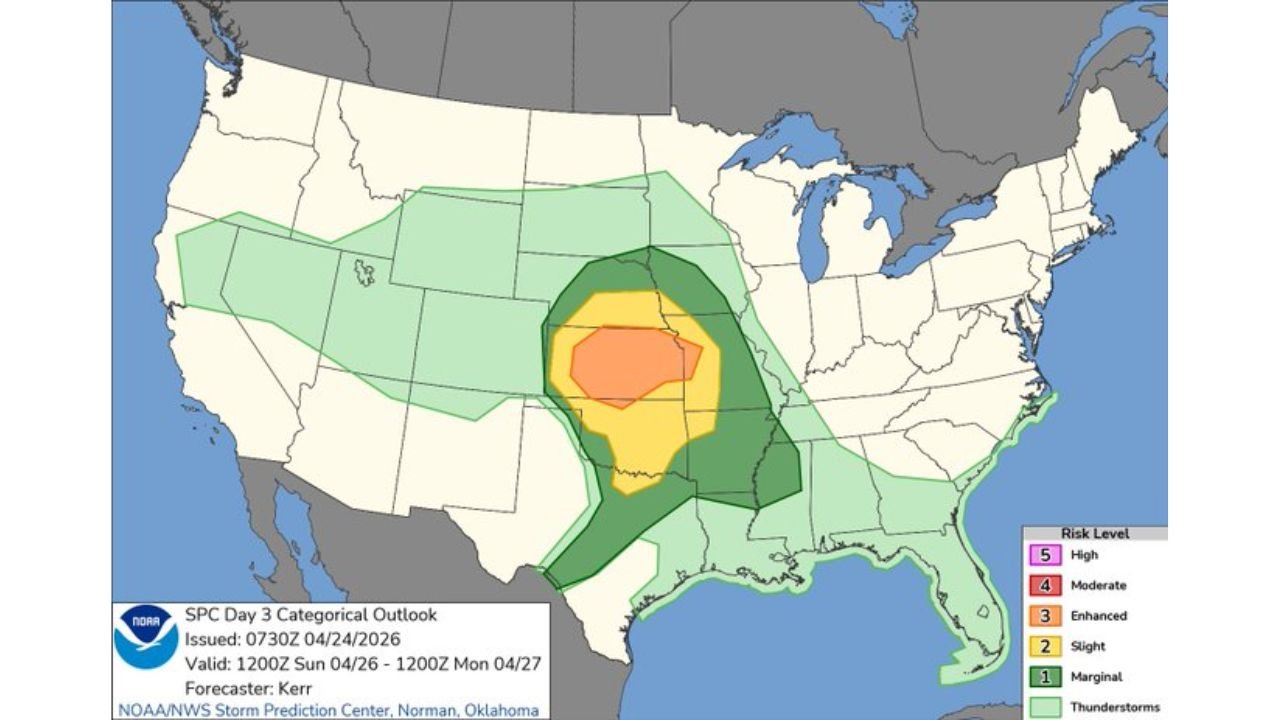
The SPC Day 3 outlook valid Sunday shows an Enhanced Risk zone across Kansas, Missouri, and surrounding areas, with all significant severe hazards remaining possible. Forecasters will continue monitoring trends through Saturday before issuing updated specifics.
Monday April 27 — Potentially the Most Dangerous Day of the Sequence
Monday is forecast to be the biggest and most dangerous day of this entire severe weather sequence. A widespread severe storm risk is expected to develop across the Mid-South and through portions of the Midwest, with the potential for a higher-end severe weather episode and a tornado outbreak.
The SPC Day 4 outlook valid Monday shows:
| Risk Zone | Probability | Areas |
|---|---|---|
| 30% severe weather probability | Highest risk | Central Illinois, Missouri, western Kentucky, Arkansas |
| 15% severe weather probability | Elevated risk | Surrounding Mid-South and Midwest corridor |
Uncertainties remain regarding exactly how Sunday’s storm activity will evolve into Monday’s setup, but forecasters are clear that all significant severe hazards remain on the table and the risk of significant impacts is high.
Three-Day Threat Summary
| Day | Date | Primary Risk Areas | Main Threats |
|---|---|---|---|
| Day 2 | Saturday April 25 | Louisiana, Oklahoma, Arkansas | Damaging winds, large hail, tornadoes |
| Day 3 | Sunday April 26 | Kansas, Missouri | Tornadoes, all severe hazards |
| Day 4 | Monday April 27 | Mid-South, Midwest, Illinois | Tornado outbreak possible, widespread severe storms |
Who Must Be Prepared Right Now
Residents across a broad corridor stretching from Oklahoma and Arkansas on Saturday, through Kansas and Missouri on Sunday, and into the Mid-South and Midwest including Illinois, Missouri, Kentucky, Arkansas, and surrounding states on Monday are all within the threat zone for this multi-day outbreak.
Do not wait until Monday to prepare. Identify your shelter location, ensure you have multiple ways to receive warnings, and stay informed as each day of this sequence develops.
Stay with CabarrusWeekly.com for continuing coverage of this significant severe weather outbreak through the weekend and into next week.