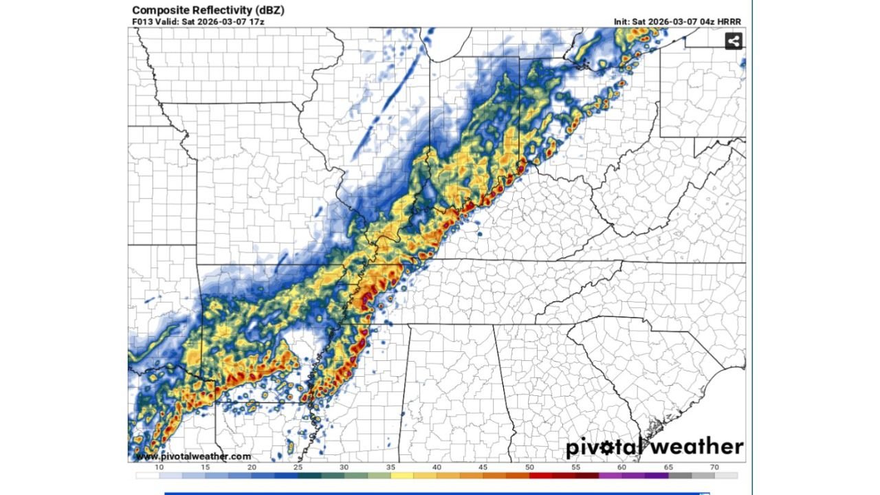
Fast-Moving Storm Line Targets Kentucky Mid to Late Morning: Damaging Wind Gusts Possible Along I-65 From Bowling Green to Louisville
KENTUCKY — A line of showers and thunderstorms is expected to sweep across the state mid to late tomorrow morning, moving steadily from west to east.
High-resolution forecast guidance shows a well-organized band of storms pushing in from western Kentucky and advancing across central portions of the state before exiting into eastern Kentucky early in the afternoon.
Timing: 10 AM to 2 PM Along I-65
The most active window for storms appears to be 10:00 a.m. through 2:00 p.m., especially along the Interstate 65 corridor.
This includes communities such as:
- Bowling Green
- Elizabethtown
- Louisville
Storms will likely reach western Kentucky first during the late morning hours before progressing eastward toward central and eastern counties.
Main Threat: Isolated Damaging Winds
While this does not appear to be a widespread severe outbreak, forecasters would not be surprised to see isolated damaging wind gusts embedded within the line.
The structure of the system suggests:
- A narrow but intense band of heavier rainfall
- Pockets of stronger wind gusts
- Brief downpours reducing visibility
Small Hail Possible
Some storms could also produce small hail, particularly where stronger updrafts briefly intensify within the line.
Tornado Risk Low — But Not Zero
The overall tornado threat is described as pretty low. However, meteorologists caution that any “kinks” or bowing segments that develop within the line could locally enhance rotation.
These small-scale features can occasionally produce quick spin-ups, though widespread tornadic activity is not expected.
What to Expect
As the line advances west to east:
- Western Kentucky will see storms first during the mid-morning
- Central Kentucky, including the I-65 corridor, will likely see peak impacts late morning into early afternoon
- Eastern Kentucky will experience storms later in the afternoon
Rainfall may be briefly heavy, but the system is progressive and should keep storms moving.
Looking Ahead
Forecasters are already monitoring another possible storm threat next Wednesday, signaling an active pattern as early March continues.
Bottom Line
A fast-moving line of storms will cross Kentucky mid to late morning, with the greatest chance for isolated damaging wind gusts along the I-65 corridor between 10 a.m. and 2 p.m. Small hail is possible, and while the tornado risk is low, brief rotation within the line cannot be completely ruled out.
CabarrusWeekly.com will continue tracking the timing and intensity of this system as it approaches.