Illinois Under Enhanced Severe Weather Risk Tuesday as Tornadoes, Large Hail and Damaging Winds Target Springfield, Peoria, Bloomington and Chicago
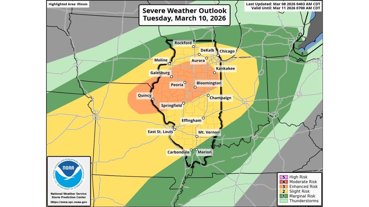
ILLINOIS — Another round of severe weather is lining up for Tuesday, March 10, and much of Illinois is already under an Enhanced Risk (Level 3 of 5) according to the Storm Prediction Center.
The latest outlook highlights a concentrated corridor of higher storm potential stretching from western Illinois through central portions of the state and into the Chicago metro area. All severe hazards are possible Tuesday afternoon into Tuesday evening — including tornadoes, very large hail, and damaging wind gusts.
Enhanced Risk Centered Over Central Illinois
The core of the Enhanced Risk zone includes communities such as:
- Springfield
- Peoria
- Bloomington
- Quincy
- Galesburg
- Moline
- Champaign
This orange-shaded area signals a greater likelihood of organized severe storms capable of producing multiple hazards.
Surrounding this region, a broader Slight Risk (Level 2) extends across much of the rest of Illinois, including:
- Chicago
- Aurora
- DeKalb
- Rockford
- Kankakee
- Effingham
- Mt. Vernon
- Carbondale
- Marion
While the highest concentration of severe potential appears centered over central and western Illinois, nearly the entire state will need to monitor Tuesday’s storm development.
Tornadoes, Very Large Hail and Damaging Winds Possible
Forecasters indicate that all severe hazards are on the table. That includes:
- Tornadoes
- Very large hail
- Damaging straight-line winds
The timing window is expected to begin Tuesday afternoon and continue into Tuesday evening. The evening component is especially important, as storms that persist after dark can pose additional risks.
The combination of instability and wind shear across Illinois appears supportive of rotating storms if discrete supercells can develop ahead of any larger storm clusters.
Central Illinois in the Bullseye
Cities like Springfield, Peoria, and Bloomington sit directly within the Enhanced Risk core, where storm intensity and organization may be strongest.
Farther north, including the Chicago metro area, the Slight Risk suggests strong storms remain possible, particularly if the more intense activity tracks slightly northward.
Western Illinois near Quincy and the Mississippi River corridor also lies within the higher-end threat zone.
What Residents Should Know
With severe weather expected Tuesday afternoon into the evening:
- Review severe weather safety plans.
- Ensure multiple ways to receive warnings.
- Pay close attention to updated forecasts as the event draws closer.
Forecast refinements over the next 24 hours may adjust the placement of the highest-risk corridor.
Bottom Line
Illinois is under an Enhanced Risk for severe weather Tuesday, with the greatest threat centered from Quincy and Springfield through Peoria and Bloomington. Tornadoes, very large hail, and damaging winds are all possible, especially during the afternoon and evening hours.
CabarrusWeekly.com will continue to monitor updates as forecasters fine-tune the storm track and timing.