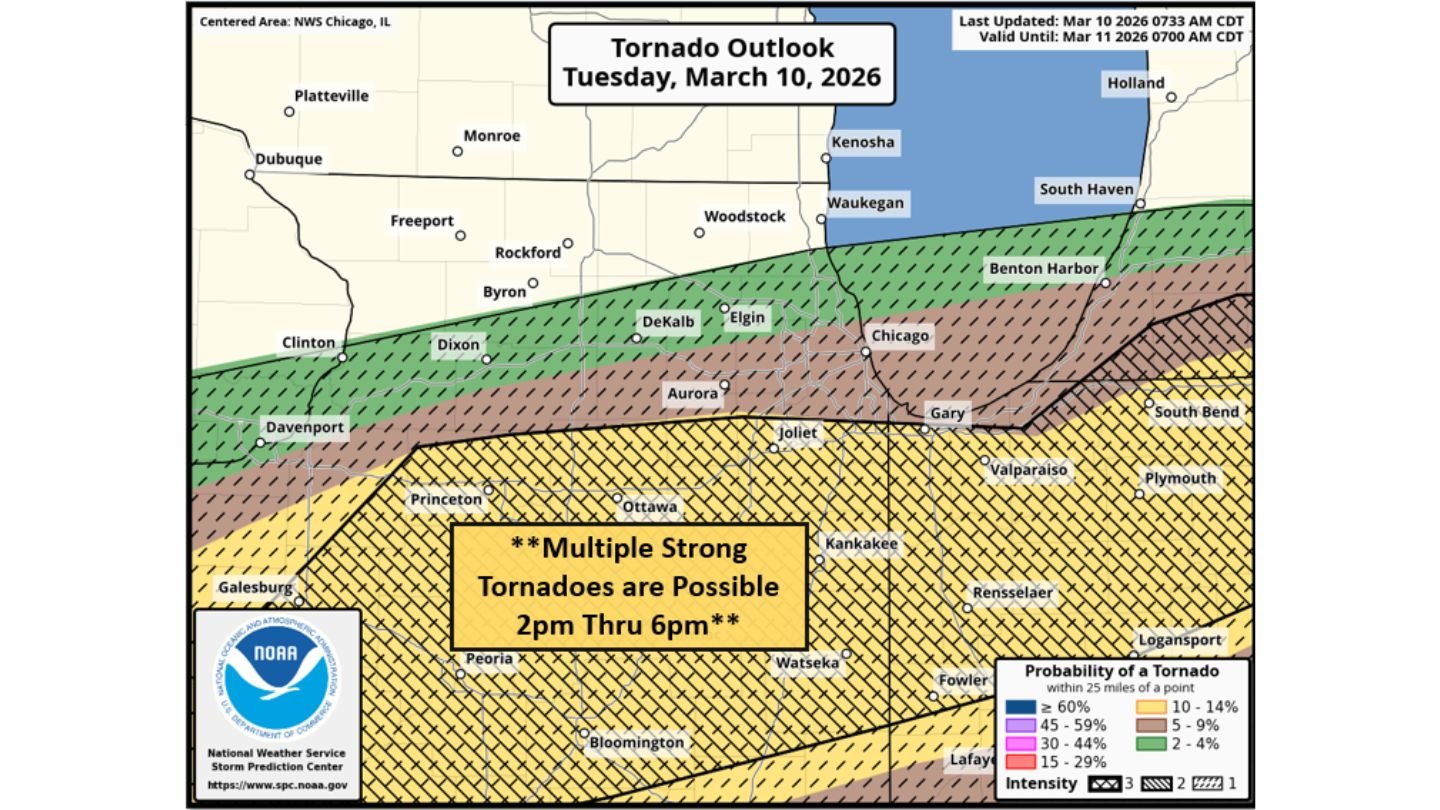
Multiple Strong Tornadoes Possible 2PM–6PM Across Central and Northern Illinois, Especially Near and South of I-80
UNITED STATES — A potentially very dangerous tornado setup is unfolding across central and northern Illinois today, with multiple strong tornadoes possible between 2PM and 6PM, especially near and south of Interstate 80.
The latest tornado outlook highlights a focused corridor of concern stretching from near Galesburg and Peoria eastward through Bloomington, Ottawa, Joliet, Kankakee and into northwest Indiana, including areas near Valparaiso and Rensselaer.
Peak Window: 2PM Through 6PM
Forecasters indicate the most intense period for tornadic supercells will likely occur from mid-afternoon into early evening.
During this window:
- Discrete supercells are expected to develop
- The atmosphere will be highly favorable for rotating storms
- Long-tracked tornadoes cannot be ruled out
This is not a marginal setup. The environment is described as very supportive of organized, sustained supercells capable of producing strong tornadoes.
Focus Area: Near and South of I-80
The corridor of greatest concern runs roughly along and south of I-80, including:
- Joliet
- Ottawa
- Kankakee
- Peoria
- Bloomington
- Watseka
Farther north, including Chicago, Elgin, DeKalb, Dixon and Rockford, storms may still occur but the strongest tornado threat appears positioned just south of that zone.
Communities across northwest Indiana, including Gary and Valparaiso, also sit near the southern edge of the higher-end tornado probabilities.
Why This Setup Is Concerning
Meteorologists note that discrete supercells forming in this environment could tap into:
- Strong wind shear
- Deep instability
- Favorable storm-relative helicity
When storms remain isolated rather than merging into lines, they are more capable of producing strong, long-track tornadoes.
The language used in the outlook suggests concern for multiple strong tornadoes, meaning tornadoes potentially reaching EF2 intensity or higher.
Dangerous Afternoon Ahead
The risk is not expected to be evenly spread across the region. Instead, a relatively narrow corridor may experience the most significant impacts. However, where storms do develop and remain organized, the threat could escalate quickly.
Residents in:
- Central Illinois
- Northern Illinois
- Northwest Indiana
should closely monitor updates throughout the day and ensure they have multiple reliable ways to receive warnings.
Bottom Line
Between 2PM and 6PM today, central and northern Illinois — particularly near and south of I-80 — face the potential for multiple strong tornadoes. Discrete supercells in a highly favorable environment could support long-tracked tornadoes in communities including Peoria, Bloomington, Joliet and Kankakee.
This is shaping up to be a high-impact severe weather afternoon across parts of Illinois. Stay weather-aware and ready to act quickly if warnings are issued.