“Texas-Sized” Hail Threat Tonight: Apple-Size or Larger Possible Across Edwards Plateau and Central Texas
UNITED STATES — Forecasters are warning that extremely large hail — potentially exceeding 3 inches in diameter — could develop this evening across parts of Texas, especially over the Edwards Plateau and into portions of central Texas west of Dallas–Fort Worth.
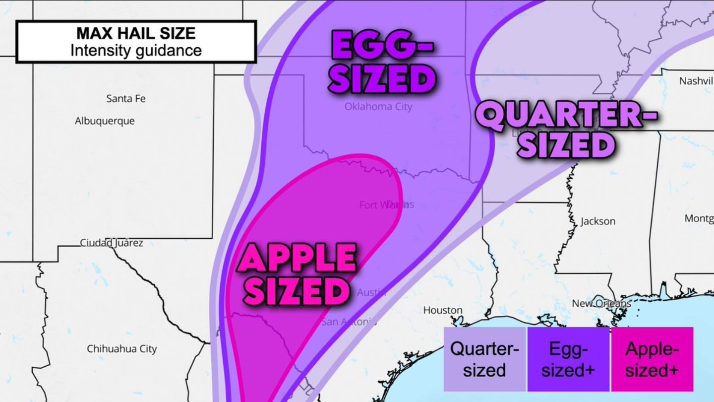
The intensity guidance map does not show the probability of hail, but instead highlights the maximum potential size if rotating thunderstorms fully mature and take advantage of the favorable atmospheric setup.
Greatest Risk: Edwards Plateau Into Central Texas
The corridor of highest concern stretches from near the Rio Grande Valley northward through:
- The Edwards Plateau
- Areas west and southwest of Austin
- West of Dallas–Fort Worth
Within this zone, apple-sized hail or larger is possible if storms remain discrete and isolated long enough to strengthen.
Thunderstorms are expected to initially form along a diffuse dryline boundary to the west before pushing eastward into richer moisture. That added moisture could allow storms to intensify rapidly.
Hail Size Breakdown
Forecast intensity guidance indicates:
- Apple-sized hail (3 inches or more) possible in parts of central Texas
- Egg-sized hail across a broader swath extending into Oklahoma
- Quarter-sized hail possible farther east into parts of the Lower Mississippi Valley
Communities near Austin, San Antonio and areas west of Fort Worth appear closest to the core zone of largest hail potential.
The Big Wildcard: Storm Mode
A key uncertainty remains whether storms will:
- Stay discrete and isolated supercells
- Or merge into lines and clusters more quickly
If storms remain isolated, they can more efficiently tap into strong updrafts and rotating cores — increasing the likelihood of very large hail.
If storms merge into linear clusters, damaging winds may become more prominent while reducing the overall hail size potential.
Rio Grande Valley Also in Play
For now, forecasters note that hail risk is also elevated near the Rio Grande Valley, where early storm development could produce large stones before moving northeast.
Timing: This Evening
The largest hail threat is expected this evening, as storms develop along the dryline and track eastward into deeper moisture.
Residents in central Texas and areas west of Dallas–Fort Worth should remain weather-aware and prepared for rapidly intensifying thunderstorms capable of producing destructive hail.
Bottom Line
This evening’s setup across Texas carries the potential for extremely large hail, possibly over 3 inches in diameter, especially across the Edwards Plateau and central Texas west of Dallas–Fort Worth. Storm behavior will determine how extreme the hail threat becomes.
CabarrusWeekly.com will continue to monitor developments as this severe weather threat evolves.