Upper Midwest & Great Lakes Face Multi-Storm Winter Siege as Michigan, Wisconsin and Minnesota Brace for Feet of Snow and Possible Blizzard Conditions
UNITED STATES — A very active stretch of winter weather is unfolding across the Upper Midwest and Great Lakes, with multiple storm systems lining up over the next week and the potential for significant snowfall totals — including areas where snow could accumulate in feet rather than inches.
Forecast guidance shows at least two additional impactful winter storms following the system currently moving through the region, and one of those could bring blizzard conditions to parts of Michigan, Wisconsin and surrounding states.
Widespread Heavy Snow Already Underway
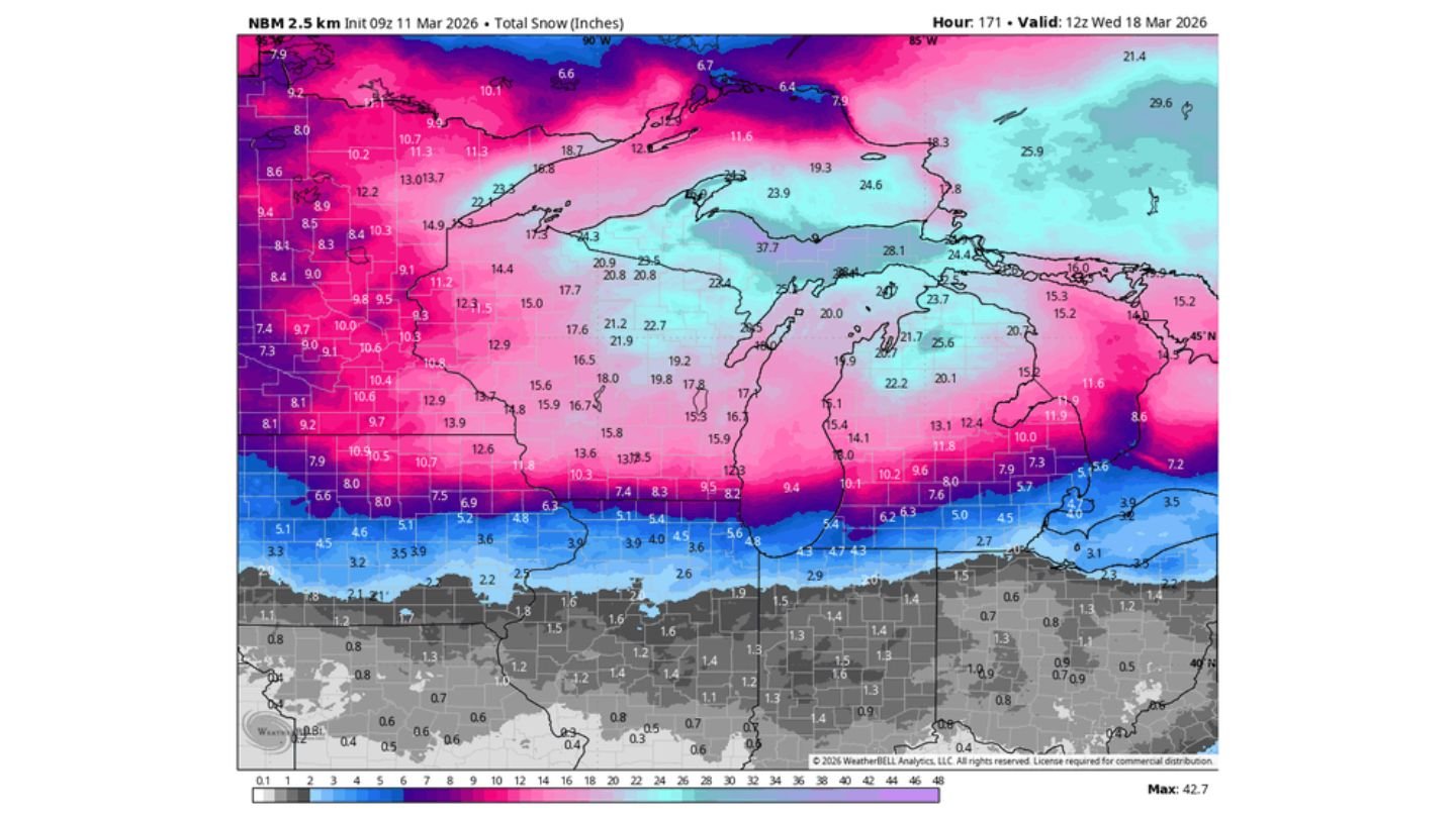
Current snowfall projections show a broad swath of double-digit totals across:
- Northern Minnesota
- Northern Wisconsin
- Much of Michigan’s Upper Peninsula
- Northern Lower Michigan
Localized totals over a foot are possible in portions of northern Wisconsin and the Upper Peninsula, with some higher terrain areas pushing well beyond that.
This is not a quick-moving clipper. The system is deep, expansive and slow enough to lay down significant snow across the region.
First Upcoming System: Expanding Snow Shield
Model guidance valid late this week shows another organized low-pressure system spreading precipitation across:
- Iowa
- Illinois
- Indiana
- Michigan
- Wisconsin
Colder air wrapping around the system supports additional snowfall across the northern half of the region, particularly across Wisconsin and Michigan.
Meanwhile, a mixed precipitation zone may set up farther south, including portions of Illinois and Indiana, before colder air eventually presses southeast.
Second Storm Could Be the Bigger Threat
By the weekend into early next week, guidance indicates a deeper and more dynamic storm organizing over the central U.S. before lifting into the Great Lakes.
Key concerns with this system include:
- A strong surface low tracking near or through Michigan
- Tight pressure gradients capable of producing strong winds
- Heavy wraparound snowfall across Wisconsin and Michigan
- Potential blizzard conditions, especially if winds align with peak snowfall
Snowfall maps suggest widespread 6–12 inch totals are possible with locally higher amounts. In some areas — particularly across northern Michigan and parts of Wisconsin — storm-total snowfall from multiple systems could approach or exceed two feet over the course of the active period.
Blizzard Potential: Why It’s on the Table
Blizzard conditions do not require extreme snowfall totals — they require sustained winds of 35 mph or greater combined with falling or blowing snow that reduces visibility to a quarter mile or less.
With a strengthening low projected to deepen as it moves into the Great Lakes, the pressure gradient may support:
- Strong northerly to northwesterly winds
- Significant blowing and drifting snow
- Dangerous travel conditions
If those winds overlap with heavy snow rates, whiteout conditions would become possible.
Winter Isn’t Letting Go
The overall pattern remains locked in with persistent troughing over the northern U.S., allowing repeated disturbances to track along the baroclinic zone separating Arctic air to the north from milder air to the south.
That means the Upper Midwest and Great Lakes — including Minnesota, Wisconsin and Michigan — are likely to remain in the crosshairs for additional winter storms beyond just one event.
What This Means Going Forward
Residents across the region should prepare for:
- Repeated rounds of accumulating snow
- Hazardous travel at times
- Possible school or business disruptions
- Increasing snowpack and drifting in rural areas
With multiple systems lined up, impacts will likely compound rather than reset between storms.
CabarrusWeekly.com will continue monitoring the evolving winter pattern as the Upper Midwest and Great Lakes brace for what could be a prolonged and impactful stretch of late-season winter weather.