Arkansas and Missouri Targeted for Major QLCS Tornado Outbreak March 15 as 45% Wind Risk Signals Dangerous Squall Line
UNITED STATES — A major wind-driven severe weather outbreak appears likely Sunday, March 15, with northeastern Arkansas and southeastern Missouri emerging as a primary target zone for embedded tornadoes within a powerful squall line.
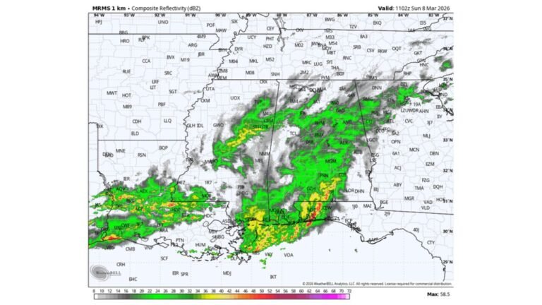
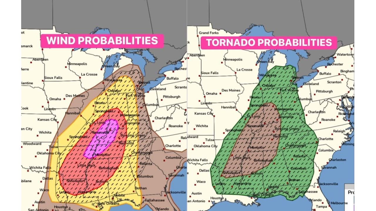
The Storm Prediction Center’s latest probability outlook highlights a 45% wind probability area — a significant signal that widespread damaging straight-line winds are expected. Within that zone, forecasters are closely monitoring the potential for QLCS tornadoes embedded in a large, fast-moving line of storms.
45% Wind Zone Highlights Significant Threat
The highest wind probabilities are centered from:
- Northeastern Arkansas, including areas near Jonesboro
- Southeastern Missouri
- Extending northeast toward southern Illinois and western Kentucky
A 45% probability of damaging winds within 25 miles of any point is a strong indicator of a high-end wind event. That level of risk often corresponds to widespread tree damage, power outages and structural impacts.
QLCS Tornado Potential
Alongside the damaging wind threat, tornado probabilities extend across much of:
- Arkansas
- Missouri
- Western Tennessee
- Western Kentucky
- Northern Mississippi
The environment favors a QLCS — a quasi-linear convective system — which is essentially a large, organized squall line capable of producing damaging winds and brief, fast-forming tornadoes.
Embedded circulations within the line can spin up quickly, sometimes with limited warning time.
Core Target: Northeast Arkansas into Southeast Missouri
Forecast discussions indicate that storm chasers and forecasters alike are focusing on the corridor from northeastern Arkansas into southeastern Missouri.
This zone sits within the overlapping area of enhanced wind and tornado probabilities, suggesting:
- A strong, organized squall line
- Multiple embedded tornadoes
- Potential for significant wind damage
Communities near Memphis, Jonesboro and extending toward Cape Girardeau should be especially alert.
Widespread Impacts Expected
Beyond the core area, the broader severe weather risk stretches north toward Illinois and Indiana and south toward Louisiana and Mississippi.
Residents across the Mid-South and lower Mississippi Valley could experience:
- 60–80 mph straight-line winds
- Power outages
- Downed trees and power lines
- Brief tornadoes embedded within the line
The fast-moving nature of QLCS events can make them particularly dangerous, especially if storms arrive after dark.
Why This Setup Is Concerning
This system features strong wind energy aloft combined with sufficient instability and moisture at the surface. When that energy consolidates into a long squall line, the result can be a “wind bag” event — meteorological shorthand for a widespread damaging wind outbreak.
The presence of enhanced tornado probabilities within the line further elevates the concern level.
Bottom Line
Arkansas and Missouri are bracing for what could be a significant QLCS tornado outbreak Sunday, March 15, with a 45% wind probability zone signaling a dangerous, fast-moving squall line.
Residents in northeastern Arkansas and southeastern Missouri should review severe weather plans, ensure alerts are enabled and prepare for rapidly changing conditions.
CabarrusWeekly.com will continue to monitor forecast updates as this potentially high-impact severe weather event approaches.