Offshore High Pressure That Blocked Carolinas Rain for Weeks Finally Weakens and Shifts Bringing Moisture Back by End of April
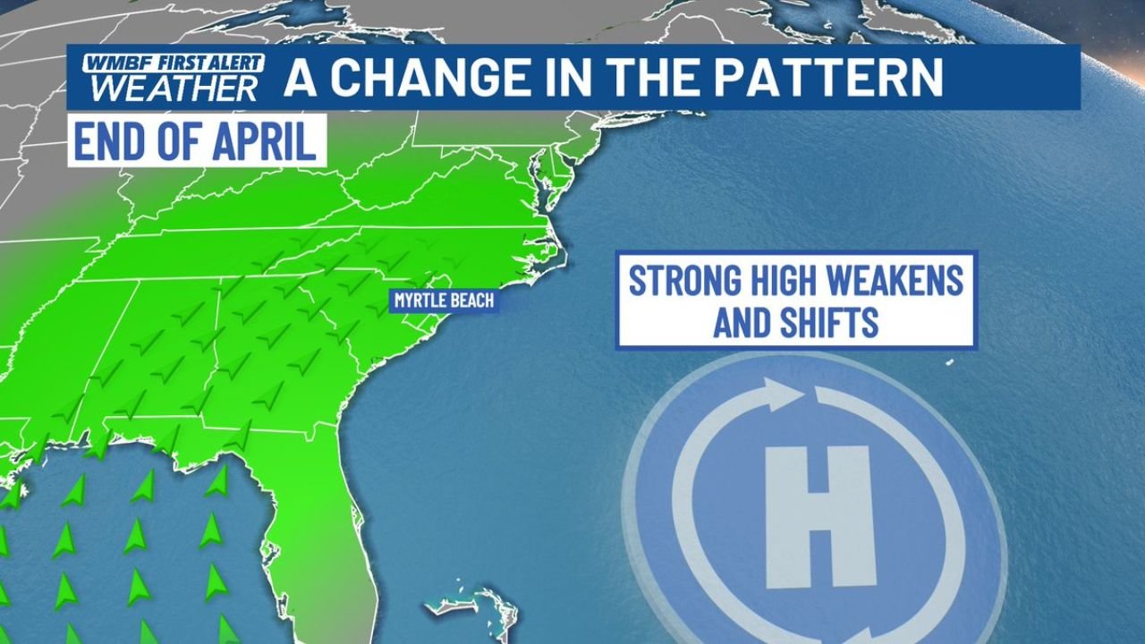
CAROLINAS — A significant pattern change is arriving for the Carolinas as the month closes out, with the large and persistent area of high pressure that has acted as a brick wall against moisture and storm systems for the past several weeks now showing clear signs of weakening and shifting — finally opening the door to humidity and at least some meaningful rainfall returning to North and South Carolina by the end of April into early May.
Strong Offshore High Blocked Every Storm System for Weeks
Over the past several weeks, a strong high pressure system parked offshore to the east of the Carolinas has effectively deflected every approaching moisture source and storm system away from the region. The clockwise circulation around this blocking high has consistently pushed weather systems northward and away from the Carolinas, leaving Myrtle Beach and surrounding coastal and inland areas trapped in a dry, rainless pattern while the rest of the eastern United States received active weather.
The result has been a prolonged and significant moisture deficit across the Carolinas during what should be one of the wetter months of the spring season.
Pattern Change Underway — High Weakens and Shifts by End of April
The blocking pattern is now breaking down. Forecast data shows the strong offshore high pressure weakening and shifting position by the end of April, eliminating the barrier that has been steering moisture away from the Carolinas. As the high retreats and repositions, onshore flow and Gulf moisture will be able to penetrate inland for the first time in weeks.
| Pattern Phase | High Pressure Status | Carolina Weather Impact |
|---|---|---|
| Past several weeks | Strong and parked offshore | All moisture blocked — dry conditions |
| End of April | Weakening and shifting | Moisture returns — rain chances increase |
| Start of May | Continued weakening | More humidity and rainfall opportunities |
At Least Some Rain Finally Returns to the Carolinas
The pattern change does not immediately promise a flood of rainfall, but it does represent a genuine and meaningful first step toward ending the prolonged dry stretch. Forecasters are indicating that at least some rain chances will return as humidity increases and weather systems are no longer deflected away from the region.
For drought-stressed areas across the Carolinas — particularly inland communities that have seen well-below-normal rainfall through the spring — any measurable precipitation will be welcome relief after weeks of the moisture-blocking offshore high shutting out every storm system.
Stay with CabarrusWeekly.com for continuing rainfall and pattern change updates across North and South Carolina through the end of April and into early May.