Third Warmest Spring on Record Gives Way to Below Normal Temperatures and 60s Highs Across the DC Region Late April Into May
WASHINGTON, DC — After logging the third warmest spring on record with an unusual number of 80-degree days, the Washington DC region is heading into a significant pattern change — with a dip in the jet stream locking in cooler than normal temperatures from April 29 through May 5, dropping afternoon highs from the expected low 70s down into the 60s and keeping the region unsettled with frequent frontal passages through the weekend and beyond.
Jet Stream Dips Over the East — Cool Pattern Locks In April 29 to May 4
Jet stream pattern data valid April 29 through May 4 shows a pronounced trough digging into the eastern United States, with below-normal heights and cool air dominating from the Great Lakes through the Mid-Atlantic and Northeast. The western United States simultaneously sits under a mild ridge — creating a classic split pattern that funnels cooler Canadian air southward across the eastern half of the country.
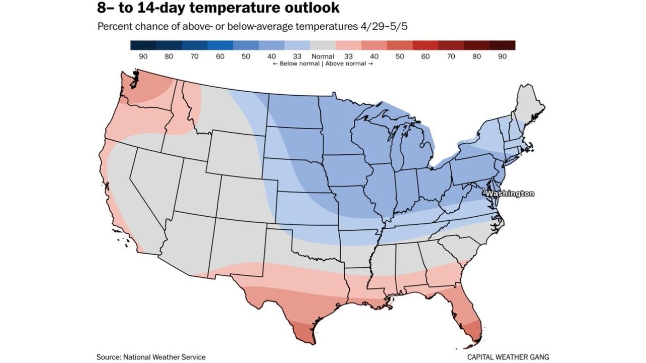
The 8 to 14 day temperature probability outlook valid April 29 through May 5 from the National Weather Service confirms the signal, showing 50 to 70 percent probability of below-normal temperatures across a wide swath covering Wisconsin, Michigan, Illinois, Indiana, Ohio, Pennsylvania, New York, and the Mid-Atlantic including Washington DC. The below-normal signal extends southward through Missouri, Iowa, and Nebraska as well.
Highs Likely in the 60s Rather Than Expected Low 70s by Early May
By early May, average highs for the DC region sit in the low 70s — but with the cooler pattern locked in, highs in the 60s become the more probable outcome for the period. Temperatures will fluctuate up and down through the week but are expected to average close to or below normal overall rather than the well-above-normal readings that dominated March and April.
| Period | Expected Pattern | Probable High Temps |
|---|---|---|
| Now through weekend | Up and down, fronts passing | Variable, near average |
| April 29 to May 5 | Below normal locked in | 60s more likely than 70s |
| Northern and western suburbs | Coldest areas | Freeze not ruled out early May |
Freeze Risk Cannot Be Ruled Out North and West of the Beltway
While another hard freeze near the Beltway is considered unlikely, forecasters note it cannot be completely ruled out for the cooler areas north and west of DC in early May. Communities in the northern Virginia foothills, western Maryland, and the Shenandoah Valley — which already recorded lows in the upper 20s during the April 22 freeze event — face the greatest exposure if temperatures dip sharply on any given night during the early May cool pattern.
Rainfall Opportunities Increase Through the Weekend
The same unsettled pattern driving cooler temperatures will also bring increased rainfall opportunities to the region as fronts pass through more frequently. This is welcome news for the DC area, which has trailed normal precipitation significantly through much of spring 2026.
Stay with CabarrusWeekly.com for continuing temperature and rainfall updates across the Washington DC region through the end of April and into early May.