Midwest and Northeast Brace for Much Below Normal Temperatures From May 11 Through May 24 as Frost Risk Looms Over the Ag Belt
UNITED STATES — A significant cool-down is on the way for a large portion of the central and eastern United States, with much below normal temperatures forecast to grip the Midwest and Northeast from May 11 through May 24, 2026, bringing with it an elevated risk of frost across the Ag Belt.
A Sharp Temperature Divide Is Setting Up Across the Country
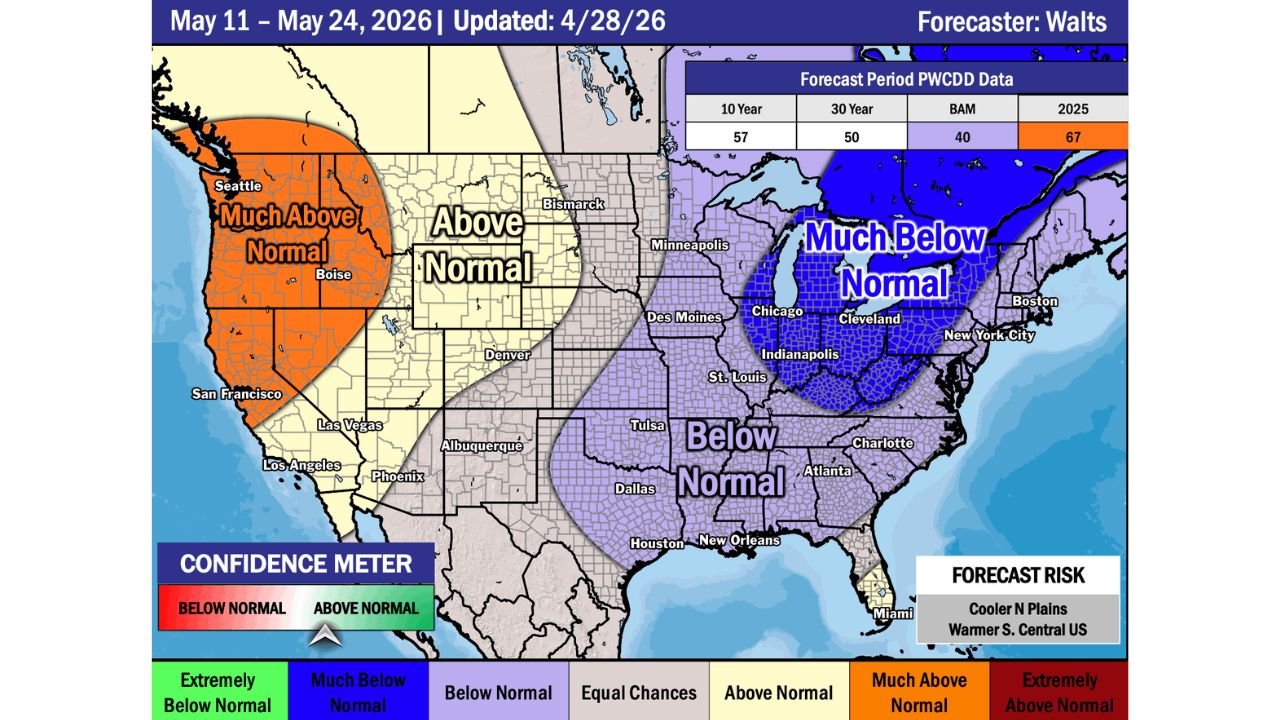
The Week 3/4 Temperature Outlook, updated April 28, 2026, shows a dramatic split across the nation. While the West Coast sees warmth, the eastern two-thirds of the country tilts cold — with the coldest anomalies concentrated in the Great Lakes, Ohio Valley, and Northeast.
Where Temperatures Will Run the Coldest
The Much Below Normal zone covers a wide area across the upper Midwest and Northeast, including Chicago, Cleveland, Indianapolis, New York City, Boston, and St. Louis. This is the most extreme cold category on the outlook and signals temperatures well below what is typical for mid-May.
A Below Normal zone extends further south and west, covering areas including Des Moines, Tulsa, Dallas, Houston, New Orleans, Atlanta, and Charlotte.
The West Tells a Very Different Story
In sharp contrast, the Pacific Coast is forecast to run Much Above Normal, covering Seattle, Boise, San Francisco, Los Angeles, Las Vegas, and Phoenix. A broad Above Normal zone spreads across the interior West through the northern and central Plains, including Bismarck, Denver, and Albuquerque.
Frost Risk Is the Key Concern for the Ag Belt
Forecasters note that the cooler temperatures are expected to stick around through mid-May in the Ag Belt, and that this prolonged cold will likely bring additional frost risks. For agricultural interests across the Midwest and central states, this is a critical concern heading into the heart of the planting season.
What the Forecast Confidence Data Shows
The outlook includes PWCDD data for the forecast period:
| 10 Year | 30 Year | BAM | 2025 |
|---|---|---|---|
| 57 | 50 | 40 | 67 |
The Confidence Meter on this outlook leans toward Below Normal, reinforcing the cold signal across the eastern half of the country. Forecast risks noted include cooler conditions across the Northern Plains and warmer conditions across the South-Central United States.
What to Expect Through the Rest of May
The pattern is not expected to be short-lived. Temperatures running much below normal through the May 11–24 window represent a multi-week cold stretch for tens of millions of people across the Great Lakes, Ohio Valley, Mid-Atlantic, and New England. Agricultural producers across the Midwest should monitor frost potential closely as this pattern takes hold.
Stay with CabarrusWeekly.com for continuing updates on this developing temperature pattern heading into mid-May.