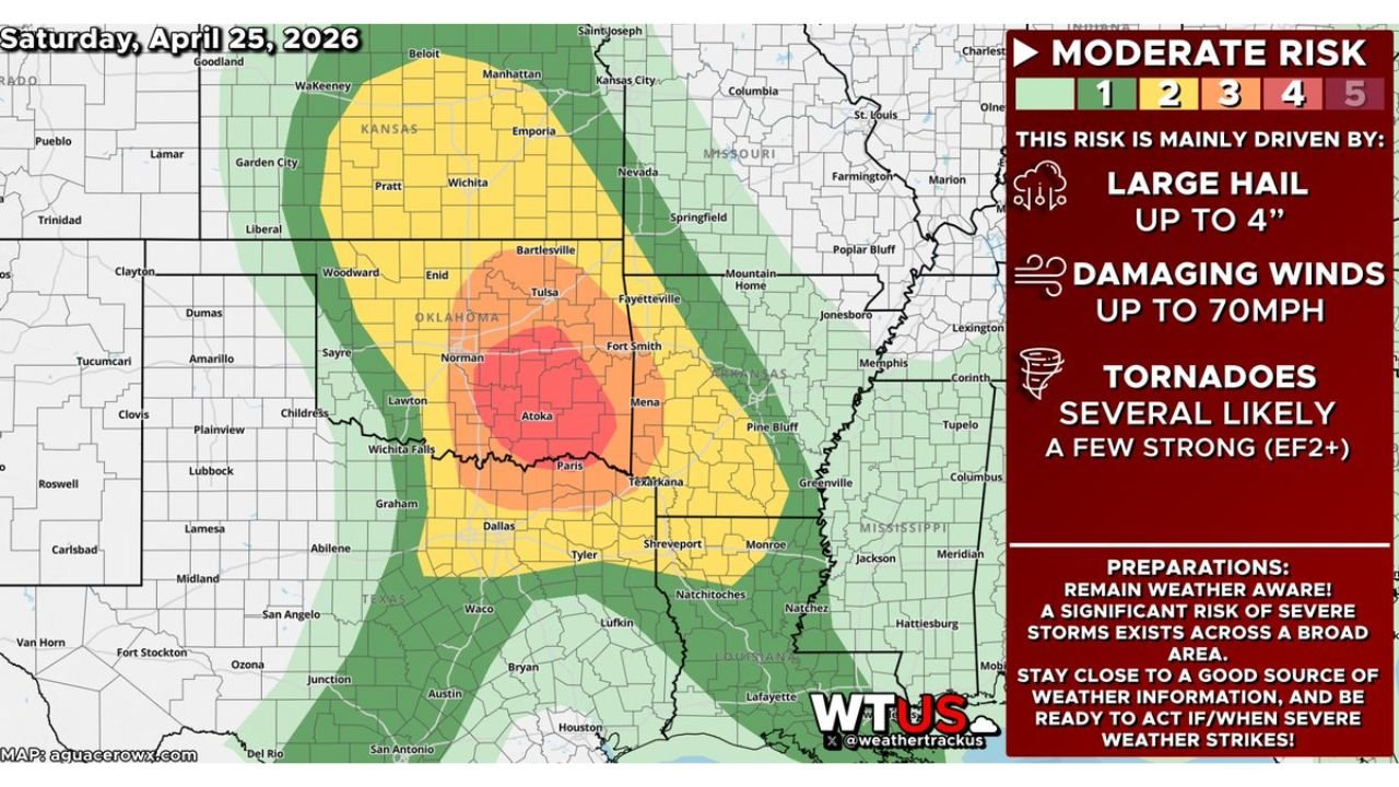
Oklahoma and Arkansas Face Level 4 Moderate Risk of Severe Storms With EF2 Tornadoes and 4-Inch Hail Possible This Saturday April 25
OKLAHOMA AND ARKANSAS — A Level 4 of 5 Moderate Risk of severe storms is in place across parts of Oklahoma and Arkansas today, Saturday, April 25, 2026, with a dangerous combination of destructive hail up to 4 inches in diameter, damaging winds up to 70 mph, and several tornadoes — a few potentially reaching EF2 to EF3 intensity — all expected mainly between 3:00 PM and midnight.
Moderate Risk Centered on Eastern Oklahoma and Western Arkansas
The highest risk zone — depicted in red on the outlook map — is centered across eastern Oklahoma including the Atoka, Ada, and Fort Smith corridor, extending into far western Arkansas and the Texarkana region. A surrounding Enhanced Risk zone covers central Oklahoma including Norman, Tulsa, and Bartlesville, while a broader Slight Risk extends into Kansas, Missouri, and parts of north Texas.
Full Hazard Breakdown
| Hazard | Threat Level |
|---|---|
| Large to destructive hail | Up to 3 to 4 inches in diameter |
| Damaging winds | Up to 70 mph |
| Tornadoes | Several likely — a few EF2 to EF3 possible |
All three hazard categories are operating simultaneously across the risk zone, making this a full-spectrum severe weather event.
Timeline for Saturday
Severe storm activity is expected to be mainly confined to the afternoon and evening hours, with the primary window running from 3:00 PM through midnight. Storms will likely develop along and east of the dryline during the mid-afternoon hours before intensifying and spreading eastward through the evening.
Cities Directly in the Risk Zone
Moderate Risk (highest): Atoka, Ada, McAlester, Fort Smith, Mena, Texarkana
Enhanced Risk: Norman, Tulsa, Bartlesville, Fayetteville, Lawton, Wichita Falls
Slight Risk: Wichita, Kansas City, Springfield, Dallas, Shreveport
Preparations to Make Right Now
Forecasters are urging residents to remain weather aware, stay close to a reliable source of weather information, and be ready to act immediately when severe weather strikes. A significant risk of severe storms exists across a broad area and conditions can deteriorate rapidly once storms initiate this afternoon.
- Get vehicles under cover before 3:00 PM — 4-inch hail will cause catastrophic vehicle damage
- Identify your shelter location now — do not wait for warnings
- Mobile homes offer no protection — move to a permanent structure before storms arrive
- Have multiple ways to receive tornado warnings active throughout the evening
Stay with CabarrusWeekly.com for continuing coverage of Saturday’s severe weather threat across Oklahoma and Arkansas.