Louisiana, Mississippi, Arkansas, Tennessee, Kentucky, Alabama, Georgia, and the Carolinas Brace for Dangerous Overnight Storms as Squall Line Races East Sunday Into Monday
SOUTHEAST UNITED STATES — A powerful line of severe storms is expected to sweep across Louisiana, Mississippi, Arkansas, Tennessee, Kentucky, Alabama, Georgia, and the Carolinas from Sunday afternoon through early Monday morning, bringing the potential for damaging winds, tornadoes, and rapidly deteriorating weather conditions overnight.
Forecasters emphasize that timing will be the most critical factor with this system, as storms move quickly across multiple states and reach some areas during the overnight hours.
Fast-Moving Storm Line Expected to Begin in Louisiana and Arkansas Sunday Afternoon
Storms are forecast to first intensify Sunday afternoon across eastern Texas, Louisiana, and Arkansas, where atmospheric conditions will allow thunderstorms to organize into a powerful squall line.
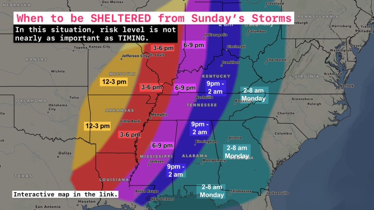
Communities across Louisiana and western Arkansas could begin seeing severe storms between 12 p.m. and 3 p.m. Sunday, with the line strengthening as it moves east.
By the late afternoon hours, the storms are expected to reach western Mississippi and eastern Arkansas between roughly 3 p.m. and 6 p.m., potentially producing strong wind gusts, heavy rain, and dangerous lightning.
Meteorologists say these early storms could quickly evolve into a larger severe weather complex capable of producing widespread wind damage.
Severe Weather Intensifies Across Mississippi, Tennessee, and Kentucky Sunday Evening
During the evening hours, the storm line is forecast to push deeper into the Mississippi Valley.
Cities across Mississippi, western Tennessee, and parts of western Kentucky could see the most intense storms between 6 p.m. and 9 p.m. Sunday.
The system is expected to strengthen further as it moves northeast, bringing the possibility of damaging straight-line winds, isolated tornadoes, and intense rainfall.
Major cities such as Memphis and Nashville fall within this timeframe, and meteorologists warn that storms may arrive suddenly with little lead time.
Overnight Severe Weather Risk Expands Into Alabama and Tennessee
As the squall line continues east Sunday night, the most dangerous period may occur across Alabama and central Tennessee, where storms could move through between 9 p.m. Sunday and 2 a.m. Monday.
This overnight window is particularly concerning because severe weather may occur while many residents are asleep.
Forecasters warn that damaging winds capable of knocking down trees and power lines remain the primary threat, though rotating storms embedded within the line could also produce isolated tornadoes.
Rapid storm movement means conditions could change quickly once the line arrives.
Storms Reach Georgia and the Carolinas Early Monday Morning
By the early morning hours Monday, the storm system is expected to shift farther east into Georgia, South Carolina, and North Carolina.
Current projections indicate the line could reach these states between 2 a.m. and 8 a.m. Monday, bringing a risk of severe thunderstorms during the early morning commute period.
While the storm intensity may gradually weaken as it moves east, strong wind gusts and locally severe storms remain possible across parts of the Southeast.
Residents across the Carolinas should be alert for rapidly changing weather conditions early Monday morning as the system exits the region.
Timing More Important Than Risk Level for This Storm System
Meteorologists stress that with this particular weather setup, the timing of the storms is more critical than the traditional risk categories used in forecasts.
Because the storms will move quickly from west to east, each state will only experience the strongest weather for a relatively short window. However, that brief window could still produce significant impacts including damaging winds and possible tornadoes.
Forecasters say residents should pay close attention to when storms are expected in their specific location, as this will determine when it is safest to seek shelter.
Overnight Preparedness Strongly Recommended
With storms expected to strike many areas overnight, experts recommend preparing ahead of time Sunday evening.
Residents should ensure they have multiple ways to receive weather alerts, including weather radios and smartphone warning systems, in case warnings are issued while they are sleeping.
Even though not every location will see severe weather, the fast-moving nature of the storm line increases the potential for sudden and dangerous conditions across much of the region.
Weather timing guidance and storm track projections referenced in this report were compiled using meteorological briefing materials.
Stay with CabarrusWeekly.com for continued updates as this severe storm system tracks across the Southeast overnight. If severe weather reaches your area, share your local conditions with the CabarrusWeekly.com community to help others stay informed.