Michigan, Wisconsin, Minnesota, Illinois, Tennessee, Mississippi, Alabama, and Louisiana Face Rare Dual Threat of Blizzard and Severe Storms as Powerful System Sweeps the U.S.
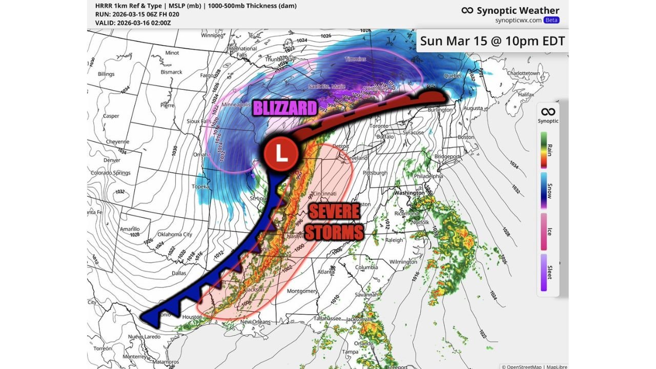
UNITED STATES — A massive storm system sweeping across the country is expected to produce two dramatically different and dangerous weather threats at the same time, bringing blizzard conditions to parts of the Upper Midwest and Great Lakes while severe thunderstorms erupt from Louisiana to Tennessee and Alabama.
Meteorologists say the powerful low-pressure system will drive intense snow, strong winds, and blizzard conditions across northern states, while warm, unstable air to the south fuels a corridor of severe storms capable of damaging winds and tornadoes.
Blizzard Conditions Expected Across Minnesota, Wisconsin, Michigan, and the Great Lakes
On the northern side of the storm system, cold air wrapping around the powerful low-pressure center will support heavy snow and strong winds across parts of Minnesota, Wisconsin, northern Michigan, and areas surrounding the Great Lakes.
As the storm intensifies Sunday night, these areas could experience blizzard conditions with heavy snow bands and rapidly falling visibility.
Strong pressure gradients surrounding the storm will generate powerful winds capable of producing blowing and drifting snow, making travel extremely dangerous across portions of the Upper Midwest.
Forecasters warn that the combination of heavy snowfall and strong winds could lead to whiteout conditions, particularly in open areas and along major highways.
Severe Storm Corridor Extends From Louisiana to Tennessee
While snow dominates the northern side of the system, a completely different threat is unfolding farther south.
A long line of thunderstorms is expected to develop along a powerful cold front stretching from Texas through Louisiana, Mississippi, Tennessee, and into parts of the Ohio Valley.
These storms could organize into a fast-moving squall line capable of producing damaging winds, heavy rain, and isolated tornadoes.
Communities from Louisiana and Mississippi through Tennessee and Alabama could experience the strongest storms as the system races northeast.
Damaging Winds Could Become Widespread
Meteorologists say the primary severe weather threat with this system will likely be widespread damaging straight-line winds.
Strong thunderstorms embedded within the squall line may produce wind gusts capable of downing trees, damaging buildings, and causing power outages across multiple states.
Because the storm line is expected to become highly organized, large sections of the Mississippi Valley could experience damaging winds as the system moves through.
In addition to wind damage, isolated tornadoes may also develop within rotating thunderstorms along the line.
Powerful Low Pressure System Driving Both Storm Types
At the center of this event is a deepening low-pressure system moving through the central United States.
North of the low, cold air and intense lift will produce heavy snow and blizzard conditions, while the southern side of the system taps into warm Gulf moisture that fuels severe thunderstorms.
This classic springtime setup allows a single storm system to generate multiple types of extreme weather across the country at the same time.
Meteorologists say the system’s size and strength are what make it particularly notable, stretching from the Great Lakes all the way down to the Gulf Coast.
Large Swath of the Country Impacted
Because the storm system spans such a wide area, millions of Americans across multiple regions could feel its effects.
Travel disruptions are possible across parts of the Upper Midwest and Great Lakes due to heavy snow, while communities across the Mississippi Valley and Southeast could face damaging thunderstorms.
Weather experts warn that these types of large-scale storm systems can produce rapidly changing conditions across different states within the same day.
Residents Urged to Monitor Weather Conditions
With both blizzard conditions and severe thunderstorms occurring simultaneously, forecasters urge residents across the affected states to remain alert for rapidly evolving weather conditions.
Travelers in northern states should be prepared for dangerous winter driving conditions, while those farther south should monitor forecasts for severe thunderstorm or tornado warnings.
Meteorologists say the combination of heavy snow, powerful winds, and severe thunderstorms makes this one of the more dynamic storm systems of the season so far.
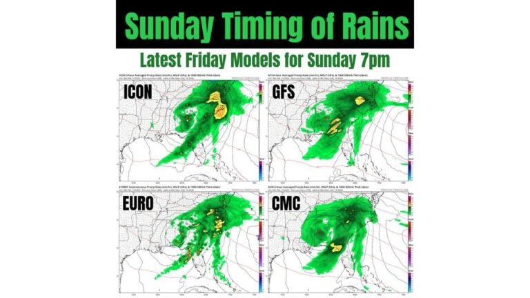
Weather model analysis and storm track projections referenced in this report were compiled using meteorological briefing materials.
Stay with CabarrusWeekly.com for continuing weather updates as this powerful storm system moves across the United States. If severe weather or winter conditions impact your area, share your local reports with the CabarrusWeekly.com community to help keep others informed.