Northern Alabama Braces for High-Impact Winter Storm With Heavy Snow Near Tennessee Line and Significant Ice South Toward I-20 This Weekend
UNITED STATES — Confidence continues to increase that a high-impact winter storm will affect the northern half of Alabama this weekend, with snow most likely near the Tennessee state line and a prolonged freezing rain threat farther south, according to consistent global model guidance and the latest forecast updates.
Snow Threat Highest Near the Tennessee River
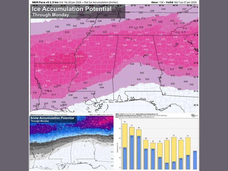
The best chance for accumulating snow remains focused on far northern Alabama, especially along and north of the Tennessee River. Some communities near the Alabama–Tennessee border could see 3 to 5 inches of snow, with localized higher totals possible if snow bands persist.
In these areas, impacts are expected to center on snow-covered roads, reduced visibility, and difficult travel, though power outages should remain isolated where precipitation stays mostly snow.
Freezing Rain Poses the Greatest Risk South of the Tennessee River
South of the Tennessee River, forecast confidence is growing in a long-duration freezing rain event driven by a shallow but very cold layer of surface air. In this setup, rain falls as liquid and freezes on contact, leading to ice accumulation on bridges, roads, trees, and power lines.
Model guidance continues to suggest potentially significant ice accumulation across much of North Alabama, a scenario that could result in widespread power outages and extremely hazardous travel conditions, especially where ice persists for many hours.
Southern Extent of Ice Threat Still Uncertain
Determining how far south the damaging ice zone extends remains the most challenging aspect of the forecast. At this time, some ice accumulation appears possible as far south as Livingston, Greensboro, Clanton, Lake Martin, and Opelika by Saturday night or Sunday morning.
However, the most significant ice impacts are currently favored along and north of Interstate 20, though forecasters stress this boundary could shift north or south as new data arrives.
Timing: When Conditions Begin to Deteriorate
The risk for snow and ice may begin as early as midnight Friday night across northwest Alabama, then expand eastward and southward. Much of the state could see wintry precipitation at times on Saturday and Sunday, with the storm finally ending Sunday night.
Even after precipitation stops, icy road conditions may persist into early next week, especially in areas with significant ice accumulation.
A Brief Thaw Is Possible — But Not Guaranteed
One potential mitigating factor is a signal in the European model showing a temporary push of slightly warmer air into parts of central Alabama Sunday afternoon. This could allow a few hours of rain with temperatures in the mid-30s, which might help ease icing conditions.
Forecasters caution there is no guarantee this warming occurs, and even a short thaw may not be enough to eliminate existing ice.
South Alabama Likely Avoids Wintry Impacts
Communities across south Alabama are expected to remain warm enough for cold rain, avoiding snow and ice. While travel impacts there should be limited, temperatures will still run below normal.
Part of a Much Larger Regional Storm
This winter storm is not limited to Alabama. It is expected to impact a wide corridor from Texas through Oklahoma, Arkansas, Tennessee, and into the Carolinas, with winter storm watches already posted to the west and likely expanding eastward as the event approaches.
What Residents Should Do Now
It remains too early for exact snowfall or ice totals, but confidence is high that travel may become difficult or even impossible across much of North Alabama, particularly along and north of I-20, this weekend.
If you live anywhere in the northern half of Alabama, now is the time to plan for hazardous travel and possible power outages. The best-case scenario is mainly cold rain. The worst-case scenario is a crippling ice storm capable of causing outages that last days or longer in isolated areas.
Forecast details will continue to be refined over the coming days. Share what you’re seeing in your area and stay updated with ongoing coverage at CabarrusWeekly.com.