A Swarm of Rotating Supercells Is Coming: Southern Wisconsin, Eastern Iowa, and Northern Illinois Face a Regional Tornado Outbreak Starting 3-4 PM Today With Tennis Ball Hail, EF2-Plus Tornadoes, and Microbursts — Employers and Schools Told to Wrap Up Early
SOUTHERN WISCONSIN — Today is the day forecasters have been warning about all week — and it is arriving fast. A regional severe weather and tornado outbreak is expected across southern Wisconsin and perhaps extreme eastern Iowa and northern Illinois this afternoon, with storms firing quickly in the 3 to 4 PM timeframe. High-resolution forecast guidance is depicting something that forecasters describe as rare enough to highlight directly — a swarm of several rotating supercells, each individually capable of destructive hail, damaging winds, and tornadoes. Multiple tornado watches and warnings will be issued today. Employers and school districts are being specifically urged to consider wrapping up activities early.
A Swarm of Rotating Supercells — What Guidance Is Showing
Forecasters are taking the unusual step of directly showing high-resolution forecast output because of what it depicts across southern Wisconsin and the surrounding region for this afternoon — and the picture it paints is alarming.
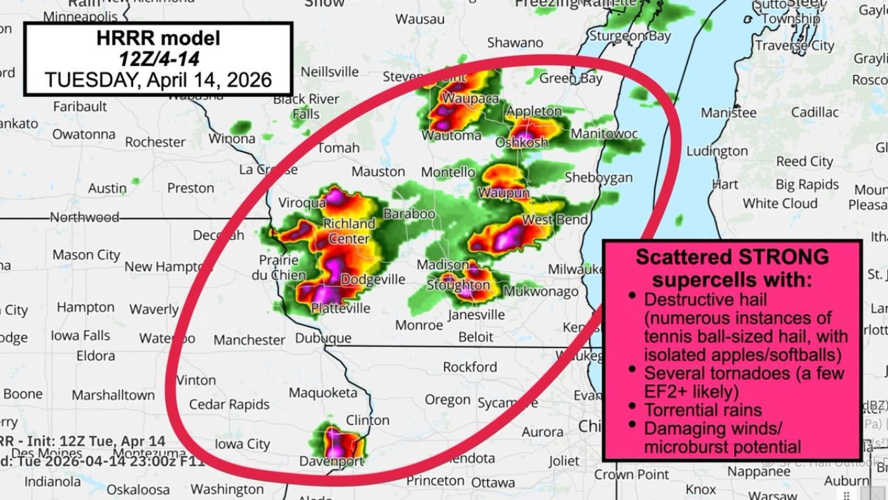
The forecast guidance shows a swarm of several rotating supercells developing and moving through the outbreak zone simultaneously. These are not ordinary thunderstorms. Each individual supercell in the swarm carries its own full suite of severe weather hazards — meaning that as one dangerous storm moves through an area, another may be developing right behind it along the same corridor.
The specific hazards identified for today’s scattered strong supercells across southern Wisconsin, eastern Iowa, and northern Illinois:
- Destructive hail — numerous instances of tennis ball-sized hail, with isolated apple and softball-sized hail possible
- Several tornadoes — a few EF-2 or stronger likely
- Torrential rains
- Damaging winds and microburst potential
The Hail Threat — Tennis Ball to Softball Size
The hail being forecast for today’s supercell swarm across southern Wisconsin goes well beyond what most people associate with a typical severe thunderstorm. The guidance is showing numerous instances of tennis ball-sized hail within the supercell swarm, with isolated stones reaching apple to softball size in the strongest individual cells.
| Hail Size | Diameter | Damage |
|---|---|---|
| Tennis ball | 2.5 inches | Shatters all vehicle glass, destroys roofing, life-threatening outdoors |
| Apple-sized | Approximately 3 inches | Catastrophic vehicle and structural damage |
| Softball-sized | 4 inches | Extreme destruction — punches through roofing, fatal if struck |
Numerous instances of tennis ball-sized hail across a regional supercell outbreak means that multiple communities will experience these extreme hail sizes — not just one isolated supercell passing over a single town, but a swarm of storms each capable of this level of hail production moving through southern Wisconsin this afternoon and evening.
The Tornado Threat — Several Expected, A Few EF-2 or Stronger Likely
The tornado component of today’s outbreak is what elevates this from a significant hail event to a regional tornado outbreak. The forecast guidance is depicting several tornadoes from the supercell swarm — and critically, a few of those tornadoes are likely to reach EF-2 or stronger.
The word likely for EF-2-plus tornadoes is among the most serious language a forecaster can use for a tornado event. It reflects genuine confidence — not just possibility — that violent tornadoes will touch down across the outbreak zone today.
Cities Inside the Outbreak Zone
The high-resolution forecast guidance shows the primary supercell activity concentrated across a defined region of southern Wisconsin extending into extreme eastern Iowa and northern Illinois.
| City | State | Status |
|---|---|---|
| Platteville | Wisconsin | Inside outbreak core |
| Dodgeville | Wisconsin | Inside outbreak core |
| Prairie du Chien | Wisconsin | Inside outbreak core |
| Richland Center | Wisconsin | Inside outbreak core |
| Viroqua | Wisconsin | Inside outbreak core |
| Baraboo | Wisconsin | Inside outbreak core |
| Madison | Wisconsin | Inside outbreak core |
| Stoughton | Wisconsin | Inside outbreak core |
| Janesville | Wisconsin | Inside outbreak core |
| Monroe | Wisconsin | Inside outbreak core |
| Beloit | Wisconsin | Near outbreak core |
| Mukwonago | Wisconsin | Inside outbreak core |
| Milwaukee | Wisconsin | Eastern edge of outbreak |
| West Bend | Wisconsin | Inside outbreak zone |
| Wautoma | Wisconsin | Inside outbreak zone |
| Oshkosh | Wisconsin | Inside outbreak zone |
| Waupaca | Wisconsin | Inside outbreak zone |
| Appleton | Wisconsin | Inside outbreak zone |
| Sheboygan | Wisconsin | Inside outbreak zone |
| Green Bay | Wisconsin | Northern outbreak zone |
| Waupun | Wisconsin | Inside outbreak zone |
| Mauston | Wisconsin | Inside outbreak zone |
| La Crosse | Wisconsin | Western outbreak zone |
| Dubuque | Iowa | Eastern Iowa edge |
| Maquoketa | Iowa | Eastern Iowa — inside zone |
| Iowa City | Iowa | Extreme eastern Iowa |
| Clinton | Iowa | Eastern Iowa edge |
| Davenport | Iowa | Southern extreme eastern Iowa |
| Aurora | Illinois | Northern Illinois outer zone |
| Rockford | Illinois | Northern Illinois zone |
Storms Fire 3 to 4 PM — The Warning System Explained
Forecasters are specifically clarifying how today’s watch and warning system will work, because understanding the difference between a watch and a warning in a regional tornado outbreak is life-critical information.
TORNADO WATCH: A watch will come out in the afternoon — essentially saying “watch out later tonight.” A watch means conditions are favorable for tornado development across a broad area. It is an advance notice to be prepared and alert — not a signal to take shelter, but a signal to finalize your shelter plan and stay informed.
TORNADO WARNING: A warning is issued when a tornado is believed to be imminent or actually occurring — detected by radar rotation or confirmed by a spotter. A WARNING means take immediate action to protect yourself right now. Do not wait. Do not look outside. Go to your shelter immediately when a tornado warning is issued for your county.
Multiple tornado watches and warnings will be issued today across the outbreak zone. This is not speculative — forecasters are stating this as a certainty for the afternoon and evening hours.
The Direct Message to Employers and School Districts
Forecasters are delivering a message that goes beyond the standard public severe weather advisory. Employers and school districts across the outbreak zone are being specifically urged to consider wrapping up activities early — before the 3 to 4 PM storm initiation window opens.
The reasoning is straightforward and critical. Schools full of children and workplaces full of employees at 3 to 4 PM — when supercells are firing and tornado watches are being issued — represent mass public safety challenges. Getting students home and employees out of office buildings and into safer shelter situations before the storm initiation begins is the difference between an orderly early dismissal and a chaotic emergency during an active tornado warning.
If you are an employer or school administrator in southern Wisconsin, eastern Iowa, or northern Illinois — the message today is direct. Consider early dismissal and early closing. The storms fire at 3 to 4 PM, and that window is approaching fast.
Everybody Needs a Severe Weather Plan — Right Now
Forecasters are equally direct in their message to the general public: everybody should have and be ready to exercise a severe weather plan. With a swarm of rotating supercells, multiple tornado warnings expected, EF-2-plus tornadoes likely, and tennis ball to softball-sized hail on the table — today is not a day where improvising shelter during a warning is an acceptable option.
- Know your shelter location right now — basement, lowest interior floor away from windows — and physically walk your family to it so there is no confusion when a warning drops
- Mobile home and manufactured home residents across the outbreak zone — evacuate to a substantial structure before 3 PM. No mobile home survives an EF-2 tornado
- Do not be outdoors between 3 PM and 10 PM across southern Wisconsin, eastern Iowa, and northern Illinois — tennis ball hail is lethal to anyone in the open
- Have NOAA weather radio active — power outages from damaging winds and microbursts could knock out phone service before the most dangerous storms arrive
- Watch and warning difference memorized — a watch means prepare, a warning means go NOW
Today’s Regional Tornado Outbreak — Full Summary
| Factor | Details |
|---|---|
| Outbreak area | Southern Wisconsin, extreme eastern Iowa, northern Illinois |
| Storm initiation | 3 to 4 PM today |
| Storm type | Swarm of several rotating supercells |
| Hail threat | Numerous tennis ball-sized — isolated apple to softball |
| Tornado threat | Several expected — a few EF-2 or stronger likely |
| Additional hazards | Torrential rain, damaging winds, microburst potential |
| Warning system | Multiple tornado watches and warnings will be issued today |
| Employer and school guidance | Consider early dismissal before 3 PM |
| Critical action | Severe weather plan ready and exercisable before storm initiation |
Southern Wisconsin — The Swarm Is Coming at 3 PM
High-resolution guidance is showing it clearly — a swarm of rotating supercells targeting southern Wisconsin, extreme eastern Iowa, and northern Illinois starting at 3 to 4 PM today. Tennis ball hail with isolated softball-sized stones. Several tornadoes with a few reaching EF-2 or stronger. Torrential rain and microburst winds. Multiple tornado watches and warnings coming this afternoon.
Employers — consider early dismissal. School districts — consider early closing. Everybody — finalize your shelter plan before 3 PM and be ready to exercise it the moment a WARNING drops for your county.
The swarm is coming. Get underground when it arrives.
Stay with CabarrusWeekly.com for live tornado outbreak coverage across southern Wisconsin, eastern Iowa, and northern Illinois — including real-time tornado warnings, storm reports, and hail confirmation throughout today’s dangerous regional severe weather event.