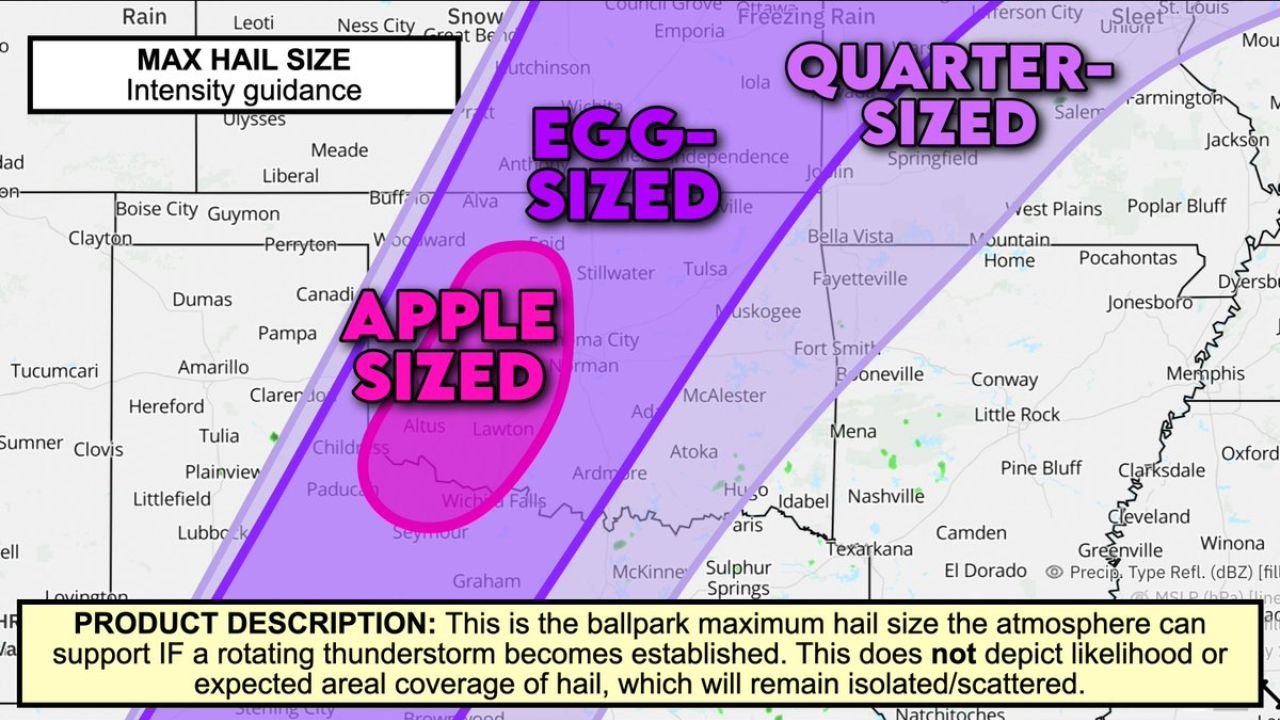
Apple-Sized Hail on the Table for Southwest Oklahoma: The Southern Plains Dryline Is Loaded for Destructive Hail Today From Lawton and Altus Through Oklahoma City and Into the Egg-Sized Zone Stretching Toward Tulsa and Wichita
SOUTHWEST OKLAHOMA — While southern Wisconsin is bracing for a tornado outbreak this afternoon, southwest Oklahoma is simultaneously facing one of the most extreme hail setups of the season. The strongest supercells firing along the southern Plains dryline today carry the atmospheric support for apple-sized hail — a genuinely destructive and dangerous hail size — centered on a corridor running through Lawton and Altus in southwest Oklahoma. The threat fans outward into an egg-sized zone covering Oklahoma City, Norman, and extending toward Tulsa, and a broader quarter-sized zone reaching across Kansas, Missouri, and into Arkansas.
What the Max Hail Size Guidance Shows
The Max Hail Size Intensity Guidance map defines three concentric zones of maximum hail potential across the southern Plains today, each representing the largest hail size the atmosphere can support if a rotating thunderstorm becomes established in that area.
| Hail Size Zone | Location | Key Cities |
|---|---|---|
| Apple-sized — innermost core | Southwest Oklahoma along the dryline | Lawton, Altus, Wichita Falls TX edge, Childress TX area |
| Egg-sized — surrounding zone | Central and eastern Oklahoma extending into Kansas | Oklahoma City, Norman, Stillwater, Tulsa, Muskogee, Enid, Alva, Woodward, Wichita KS |
| Quarter-sized — outer zone | Broader surrounding area | Emporia KS, Joplin MO, Springfield MO, Fayetteville AR, Fort Smith AR, Jonesboro AR, Memphis TN edge |
The apple-sized core sits as a defined oval directly over Lawton and Altus — the southwest Oklahoma corridor along the dryline where storm initiation and the most organized supercell development is expected today.
Understanding Each Hail Size — What They Mean on the Ground
| Hail Size | Diameter | What It Does |
|---|---|---|
| Quarter-sized | 1.00 inch | Dents vehicles, damages crops, breaks weak skylights |
| Egg-sized | Approximately 1.75 inches | Shatters vehicle glass, significant roof damage, injures anyone outdoors |
| Apple-sized | Approximately 3.00 inches | Destroys vehicles completely, punches through roofing, life-threatening to anyone outdoors |
Apple-sized hail at 3 inches is among the most destructive hail sizes that any thunderstorm can produce. At that diameter and falling at terminal velocity, a single hailstone carries enough kinetic energy to:
- Completely shatter every window on an unprotected vehicle and dent or penetrate the roof
- Punch through standard residential roofing materials including shingles and underlayment
- Cause severe or fatal injury to any person caught outdoors without overhead cover
- Destroy crops, equipment, and outdoor property across any area it passes through
The Critical Product Description — What This Map Does and Does Not Show
The map carries an explicit and important disclaimer that every resident in the affected area needs to understand:
This is the ballpark maximum hail size the atmosphere can support IF a rotating thunderstorm becomes established. This does NOT depict likelihood or expected areal coverage of hail, which will remain isolated and scattered.
This means:
- Most locations in the apple-sized zone will not see apple-sized hail today — coverage is isolated and scattered
- IF a supercell fires and establishes rotation in southwest Oklahoma, the atmosphere has the energy to support apple-sized hailstones from that storm
- The map shows maximum potential — not guaranteed widespread coverage
- The uncertainty cuts both ways — a storm that fires and sustains rotation in Lawton or Altus today could produce catastrophic hail with very little geographic warning
This distinction makes preparation more important, not less. Because coverage is scattered, there is limited ability to predict exactly which communities will take a direct hit — meaning everyone in the apple-sized and egg-sized zones needs to be prepared as if the worst-case hail could fall on them specifically.
Cities and Their Hail Threat Zone — Southwest Oklahoma to the Mississippi Valley
Apple-Sized Zone — Southwest Oklahoma Core:
| City | State | Max Hail Potential |
|---|---|---|
| Lawton | Oklahoma | Apple-sized |
| Altus | Oklahoma | Apple-sized |
| Wichita Falls | Texas | Near apple-sized zone |
| Childress | Texas | Near apple-sized zone |
Egg-Sized Zone — Central and Eastern Oklahoma Through Kansas:
| City | State | Max Hail Potential |
|---|---|---|
| Oklahoma City | Oklahoma | Egg-sized |
| Norman | Oklahoma | Egg-sized |
| Stillwater | Oklahoma | Egg-sized |
| Tulsa | Oklahoma | Egg-sized |
| Muskogee | Oklahoma | Egg-sized |
| Enid | Oklahoma | Egg-sized |
| Alva | Oklahoma | Egg-sized |
| Woodward | Oklahoma | Egg-sized |
| Wichita | Kansas | Egg-sized |
| Guymon | Oklahoma | Near egg-sized |
| Boise City | Oklahoma | Near egg-sized |
| Amarillo | Texas | Near outer egg zone |
Quarter-Sized Zone — Kansas Through Missouri and Arkansas:
| City | State | Max Hail Potential |
|---|---|---|
| Emporia | Kansas | Quarter-sized |
| Joplin | Missouri | Quarter-sized |
| Springfield | Missouri | Quarter-sized |
| Fayetteville | Arkansas | Quarter-sized |
| Fort Smith | Arkansas | Quarter-sized |
| Jonesboro | Arkansas | Quarter-sized |
| Bella Vista | Arkansas | Quarter-sized |
| Conway | Arkansas | Quarter-sized |
| Memphis | Tennessee | Near outer quarter zone |
Southwest Oklahoma Is Especially at Risk — The Dryline Factor
Forecasters specifically call out southwest Oklahoma as the area of greatest concern for large destructive hail today. The southern Plains dryline — the boundary between dry air from the west and moist air from the Gulf — is the primary trigger mechanism for storm initiation in this area today.
When supercells fire along a dryline in an environment with this level of atmospheric energy, they can rapidly intensify — quickly developing the powerful rotating updrafts needed to loft and grow hailstones to destructive sizes before dropping them. The dryline position today puts Lawton, Altus, and the southwest Oklahoma corridor directly in the zone where that rapid intensification is most likely to occur.
What to Do Right Now If You Are in the Apple or Egg-Sized Zones
For Lawton, Altus, and southwest Oklahoma inside the apple-sized zone:
- Get every vehicle under solid overhead cover immediately — this is not optional. Apple-sized hail will completely destroy any unprotected vehicle in seconds
- Do not go outside when storm sirens sound or when hail begins — 3-inch hailstones are fatal to anyone in the open
- Stay away from windows — apple-sized hail can shatter residential windows and send glass and stone fragments deep into interior spaces
- Bring in all animals and outdoor property before storms approach
For Oklahoma City, Norman, Tulsa, and the egg-sized zone:
- Vehicle protection is critical — egg-sized hail at 1.75 inches will shatter glass and cause severe roof damage to unprotected cars
- Stay indoors and away from windows when hail begins
- Monitor warnings closely — a storm that moves from the apple-sized zone into the egg-sized zone could arrive still producing extreme hail sizes
Southwest Oklahoma Hail Threat at a Glance
| Factor | Details |
|---|---|
| Maximum hail size | Apple-sized — approximately 3 inches — Lawton and Altus core |
| Egg-sized zone | Oklahoma City, Norman, Tulsa, Wichita corridor |
| Quarter-sized zone | Joplin, Springfield MO, Fayetteville, Fort Smith, Jonesboro, Memphis edge |
| Storm trigger | Southern Plains dryline — southwest Oklahoma |
| Coverage | Isolated and scattered — but extreme where it hits |
| Key disclaimer | Maximum potential IF rotating storm establishes — not guaranteed coverage |
| Highest local concern | Southwest Oklahoma specifically along the dryline |
The Dryline Is Loaded — Southwest Oklahoma Faces the Worst of It
The southern Plains dryline is primed today, and the atmosphere across southwest Oklahoma has the energy to support apple-sized hail from any supercell that fires and establishes rotation along it. Lawton and Altus sit in the direct bullseye of today’s maximum hail potential. The egg-sized zone reaches through Oklahoma City, Norman, Tulsa, and Wichita, and the quarter-sized zone extends across Kansas, Missouri, and Arkansas.
Coverage will be isolated and scattered — but where these storms hit, the damage will be catastrophic and immediate. Southwest Oklahoma needs vehicles covered, people indoors, and alerts active before storm initiation begins along the dryline this afternoon.
Stay with CabarrusWeekly.com for live hail reports across southwest Oklahoma, storm tracking along the southern Plains dryline, and real-time severe thunderstorm warnings across the Lawton, Altus, Oklahoma City, and Tulsa corridor as today’s dangerous supercell event unfolds.